Callaway County, Missouri
Callaway County is a county located in the U.S. state of Missouri. As of the 2010 United States Census, the county's population was 44,332.[1] Its county seat is Fulton.[2] With a border formed by the Missouri River, the county was organized November 25, 1820, and named for Captain James Callaway, grandson of Daniel Boone.[3] The county has been historically referred to as "The Kingdom of Callaway" after an incident in which some residents confronted Union troops during the U.S. Civil War.[4]
Callaway County | |
|---|---|
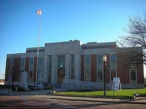 The Callaway County Courthouse in Fulton | |
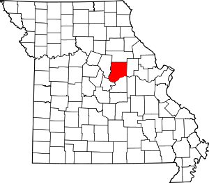 Location within the U.S. state of Missouri | |
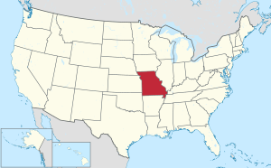 Missouri's location within the U.S. | |
| Coordinates: 38°50′N 91°55′W | |
| Country | |
| State | |
| Founded | November 25, 1820 |
| Named for | James Callaway |
| Seat | Fulton |
| Largest city | Fulton |
| Area | |
| • Total | 847 sq mi (2,190 km2) |
| • Land | 835 sq mi (2,160 km2) |
| • Water | 13 sq mi (30 km2) 1.5% |
| Population (2010) | |
| • Total | 44,332 |
| • Estimate (2018) | 44,889 |
| • Density | 52/sq mi (20/km2) |
| Time zone | UTC−6 (Central) |
| • Summer (DST) | UTC−5 (CDT) |
| Congressional district | 3rd |
| Website | callawaycounty |
Callaway County is part of the Jefferson City, Missouri, Metropolitan Statistical Area.
Vineyards and wineries were first established in the area by German immigrants in the mid-19th century. Among the first mentioned in county histories are those around the southeastern Callaway settlement of Heilburn, a community neighboring Portland, on the Missouri River.[5] Since the 1960s, there has been a revival of winemaking there and throughout Missouri.
The Callaway Nuclear Generating Station is located in Callaway County, near Fulton.
History
This area was historically occupied by the Osage and other Native American peoples, some of whom migrated from east of the Ohio River Valley. Others emerged as cultures in this area, following thousands of years of settlement by indigenous peoples.
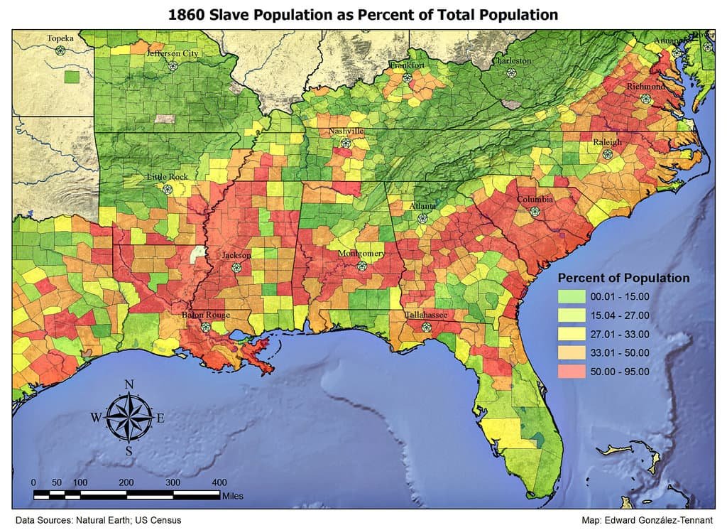
The early European-American settlement of Callaway County was largely by migrants from the Upper South states of Virginia, Kentucky, and Tennessee, with an influx of German immigrants starting in the 1830s,[6] as was the case with other counties along the Missouri River. Some of them brought Black enslaved persons and enslavement practices with them, and quickly started cultivating hemp and tobacco, the same crops as were grown in Middle Tennessee and Kentucky. Given their culture and traditions, this area became known as Little Dixie.[7] By 1860, enslaved people made up at least 25 percent of the county's population,[8] higher than in most parts of the state.
On October 27, 1860, a Black woman known as "Slave Teney" was lynched by whites near Fulton after she confessed to killing the daughter of her owner.[9][10]
Some pioneer families from Callaway and Lewis County, Missouri, moved to the West and became influential early settlers of the nascent state of California. Callaway families helped settle areas of California near the Oregon border, as they entered the state via the Oregon Trail, then southward toward San Francisco. Lewis County relatives helped build Sacramento and develop viticulture in the California Central Valley and areas north of San Francisco Bay. Some of these Missouri families, later key U.S./Unionist advocates and military personnel during the U.S. Civil War, held early local and statewide political offices in California.[11]
The minutes of the U.S. Congressional hearing on the legitimacy of U.S. Civil-war-era elections in Callaway County include reports of substantial election meddling and voter harassment and intimidation, summarized in the 1867-68 Reports of Committees of the House of Representatives. It described the Confederate support in the county, citing prominent citizens, but the report also demonstrated that there was substantial county support for Union/U.S. government among citizens who were often intimidated into silence. Historians therefore cannot ascertain exact percentages of Union or Confederate sympathies in the county.[12]
The Battle of Moore's Mill was the only significant Civil War battle that took place in Callaway County. One historian said it was known as "Kingdom of Callaway". A truce with U.S./Union forces during the war effectively allowed Confederate advocates to continue to operate under surveillance, in proximity to the Missouri government offices in Jefferson City. There may have been more than twice as many Confederate as U.S./Union troops in Callaway. A so-called "Confederate government of Missouri" set up offices in southwest Missouri near the Arkansas border, while a line almost straight south along the Arkansas-Oklahoma border connected it to a known Texas-affiliate (and possibly controlling) office set up across from the southwest corner of Arkansas in Marshall, Texas.[13][14]
According to "A Short History of Callaway County" by Ovid Bell, the publisher of the (county seat) Fulton Daily Sun Gazette, "Fulton was occupied during the greater part of the war by Union soldiers and militia, and Southern (i.e. Confederate) sympathizers were in constant fear of imprisonment and death." U.S. forces loyal to the Union were raised by Captains William T Snell, Henry Thomas, and JJP Johnson. They were reinforced by troops under General John B. Henderson from the town of Louisiana in Pike County, Missouri.[15]
After the late-1860s Reconstruction era, an element of white residents in the state and county worked to restore white supremacy. Violence against Black people reached a peak around the turn of the 20th century, when whites lynched a total of four African Americans in the county.[16] The victims included Ham Peterson in May 1884, killed because his brother spoke disrespectfully to whites; an unnamed African-American man killed by a mob in October 1884, after being accused of raping a young girl; and Emmett Divens, lynched August 15, 1895.[9][17]
Other settlers in the Missouri River valley included German immigrants from the mid-19th century following the Revolutions of 1848 in the German states; they established a strong wine industry in the area and built towns with German-influenced architecture, concentrated substantially in counties south of Callaway and across the Missouri River, celebrated annually in the Maifest events in the Gasconade county seat, Hermann. Missouri was the second-largest wine-producing state nationally until Prohibition. Since the 1960s, numerous vineyards and wineries have been established again in the river valley, including Summit Lake Winery in Holts Summit. One definition of the Missouri Rhineland can be found in a Chicago Tribune article of September 2018.[18]
Callaway has remained largely agricultural, economically, with its rich farmlands, yet borders Missouri's capital city and Lincoln University (Missouri) in Cole County, to the south, and the main University of Missouri campus in Columbia, 40 miles or less from the most populous areas of the county. Callaway County has for years hosted William Woods University and Westminster College in the county seat, Fulton, while Osage county, to the south, hosts the State Technical College of Missouri in Linn.
Geography
According to the U.S. Census Bureau, the county has a total area of 847 square miles (2,190 km2), of which 835 square miles (2,160 km2) is land and 13 square miles (34 km2) (1.5%) is water.[19]
The northern part of the county is relatively flat and devoid of large tracts of forests. The southern border of the county is the Missouri River, and the area is heavily forested over large hills and valleys. Cedar Creek makes up the bulk of the county's western border. Jefferson City lies across the Missouri River from the southwestern corner of the county.[20][21]
Adjacent counties
- Audrain County (north)
- Montgomery County (east)
- Osage County (south)
- Cole County (southwest)
- Boone County (west)
- Gasconade County (southeast)
Major highways
.svg.png)


National protected areas
Climate
| ||||||||||||||||||||||||||||||||||||||||||||||||||||||||||||||||||||||||||||||||||||||||||||||||||||||||||||||||||||||||||||
Demographics
| Historical population | |||
|---|---|---|---|
| Census | Pop. | %± | |
| 1830 | 6,159 | — | |
| 1840 | 11,765 | 91.0% | |
| 1850 | 13,827 | 17.5% | |
| 1860 | 17,449 | 26.2% | |
| 1870 | 19,202 | 10.0% | |
| 1880 | 23,670 | 23.3% | |
| 1890 | 25,131 | 6.2% | |
| 1900 | 25,984 | 3.4% | |
| 1910 | 24,400 | −6.1% | |
| 1920 | 23,007 | −5.7% | |
| 1930 | 19,923 | −13.4% | |
| 1940 | 23,094 | 15.9% | |
| 1950 | 23,316 | 1.0% | |
| 1960 | 23,858 | 2.3% | |
| 1970 | 25,850 | 8.3% | |
| 1980 | 32,252 | 24.8% | |
| 1990 | 32,809 | 1.7% | |
| 2000 | 40,766 | 24.3% | |
| 2010 | 44,332 | 8.7% | |
| Est. 2018 | 44,889 | [23] | 1.3% |
| U.S. Decennial Census[24] 1790-1960[25] 1900-1990[26] 1990-2000[27] 2010-2015[1] | |||
As of the census[28] of 2000, there were 40,766 people, 14,416 households, and 10,336 families residing in the county. The population density was 49 people per square mile (19/km²). There were 16,167 housing units at an average density of 19 per square mile (7/km²). The racial makeup of the county was self-identified as 91.79% White, 5.66% Black or African American, 0.52% Native American, 0.52% Asian, 0.01% Pacific Islander, 0.30% from other races, and 1.21% from two or more races. Approximately 0.92% of the population identified as Hispanic or Latino of any race. 29.9% identified as of German ancestry, 22.0% s American, 9.1% as Irish (including Scots-Irish) and 9.1% as English ancestry.
There were 14,416 households out of which 35.80% had children under the age of 18 living with them, 57.10% were married couples living together, 10.40% had a female householder with no husband present, and 28.30% were non-families. 23.00% of all households were made up of individuals and 8.80% had someone living alone who was 65 years of age or older. The average household size was 2.56 and the average family size was 3.00.
In the county, the population was spread out with 25.40% under the age of 18, 11.10% from 18 to 24, 31.00% from 25 to 44, 21.50% from 45 to 64, and 11.00% who were 65 years of age or older. The median age was 35 years. For every 100 females, there were 107.60 males. For every 100 females age 18 and over, there were 108.90 males.
The median income for a household in the county was $39,110, and the median income for a family was $44,474. Males had a median income of $29,574 versus $22,317 for females. The per capita income for the county was $17,005. About 6.00% of families and 8.50% of the population were below the poverty line, including 10.30% of those under age 18 and 8.30% of those age 65 or over.
Education
Public schools
- Fulton School District No. 58 – Fulton
- McIntire Elementary School (PK-05)
- Bush Elementary School (K-05)
- Bartley Elementary School (K-05)
- Fulton Middle School (06-08)
- Fulton High School (09-12)
- Missouri School for the Deaf – Fulton
- Stark Elementary School (K-05)
- Wheeler Middle School (06-08)
- Wheeler High School (09-12)
- New Bloomfield R-III School District – New Bloomfield
- New Bloomfield Elementary School (PK-06)
- New Bloomfield High School (07-12)
- North Callaway County R-I School District – Kingdom City
- Auxvasse Elementary School (PK-08) – Auxvasse
- Hatton-McCredie Elementary School (K-08)
- Williamsburg Elementary School (K-08)
- North Callaway County High School (09-12)
- South Callaway County R-II School District – Mokane
- South Callaway County Early Childhood Education Center (PK-02)
- South Callaway County Elementary School (03-05)
- South Callaway County Middle School (06-08)
- South Callaway County High School (09-12)
Private schools
- St. Peter Catholic School – Fulton (K-09) – Roman Catholic
- Kingdom Christian Academy – Fulton (PK-09) – Nondenominational Christian
- Shepherdsfield School – Fulton (K-12) – Nondenominational Christian
Post-secondary
- Westminster College - Fulton - A private, four-year Presbyterian university.
- William Woods University - Fulton - A private, four-year university.
Public libraries
Politics
Local
The Republican Party completely controls politics at the local level in Callaway County.
| Callaway County, Missouri | ||||
|---|---|---|---|---|
| Elected countywide officials | ||||
| Assessor | Jody Paschal | Republican | ||
| Circuit Clerk | Judy O. Groner | Republican | ||
| County Clerk | Denise Hubbard | Republican | ||
| Collector | Sarah Gladman | Republican | ||
| Commissioner (Presiding) |
Gary Jungermann | Republican | ||
| Commissioner (District 1) |
Randall L. Kleindienst | Republican | ||
| Commissioner (District 2) |
Donald “Doc” Kritzer | Republican | ||
| Prosecuting Attorney | Christopher Wilson | Republican | ||
| Public Administrator | Karen Digh | Republican | ||
| Recorder | Christine Kleindienst | Republican | ||
| Sheriff | Clay Chism | Republican | ||
| Treasurer | Debbie Zerr | Republican | ||
State
| Year | Republican | Democratic | Third Parties |
|---|---|---|---|
| 2016 | 57.95% 11,149 | 38.15% 7,340 | 3.89% 749 |
| 2012 | 52.30% 9,486 | 44.17% 8,012 | 3.53% 640 |
| 2008 | 49.78% 9,596 | 48.63% 9,375 | 1.59% 306 |
| 2004 | 57.27% 10,153 | 41.59% 7,373 | 1.13% 201 |
| 2000 | 43.62% 6,641 | 53.40% 8,129 | 2.98% 453 |
| 1996 | 32.91% 4,314 | 63.91% 8,379 | 3.18% 417 |
Callaway County is divided into two legislative districts in the Missouri House of Representatives, both of which are held by Republicans.
- District 43 — Jay D. Houghton (R-Martinsburg). Consists of the communities of Auxvasse, Portland, Steedman, and Williamsburg.
| Party | Candidate | Votes | % | ± | |
|---|---|---|---|---|---|
| Republican | Jay D. Houghton | 3,169 | 72.93% | +0.90 | |
| Democratic | Ed Lockwood | 1,176 | 27.07% | -0.90 | |
| Party | Candidate | Votes | % | ± | |
|---|---|---|---|---|---|
| Republican | Jay Houghton | 1,816 | 72.03% | +7.71 | |
| Democratic | Ed Lockwood | 705 | 27.97% | -7.71 | |
| Party | Candidate | Votes | % | ± | |
|---|---|---|---|---|---|
| Republican | Jay Houghton | 2,653 | 64.32% | ||
| Democratic | Ed Lockwood | 1,472 | 35.68% | ||
- District 49 — Travis Fitzwater (R-Holts Summit). Consists of the communities of Fulton, Holts Summit, Kingdom City, Lake Mykee Town, Mokane, New Bloomfield, and Tebbetts.
| Party | Candidate | Votes | % | ± | |
|---|---|---|---|---|---|
| Republican | Travis Fitzwater | 12,448 | 100.00% | +38.22 | |
| Party | Candidate | Votes | % | ± | |
|---|---|---|---|---|---|
| Republican | Travis Fitzwater | 5,126 | 61.78% | -8.44 | |
| Democratic | Gracia Yancey Backer | 3,171 | 38.22% | +8.44 | |
| Party | Candidate | Votes | % | ± | |
|---|---|---|---|---|---|
| Republican | Jeanie Riddle | 9,610 | 70.22% | ||
| Democratic | Pamela Murray | 4,075 | 29.78% | ||
All of Callaway County is a part of Missouri's 10th District in the Missouri Senate and is currently represented by Jeanie Riddle (R-Fulton).
| Party | Candidate | Votes | % | ± | |
|---|---|---|---|---|---|
| Republican | Jeanie Riddle | 7,993 | 73.66% | ||
| Democratic | Ed Schieffer | 2,858 | 26.34% | ||
Federal
| Party | Candidate | Votes | % | ± | |
|---|---|---|---|---|---|
| Republican | Roy Blunt | 10,983 | 57.24% | +9.19 | |
| Democratic | Jason Kander | 7.084 | 36.92% | -7.27 | |
| Libertarian | Jonathan Dine | 534 | 2.78% | -4.98 | |
| Green | Johnathan McFarland | 238 | 1.24% | +1.24 | |
| Constitution | Fred Ryman | 347 | 1.81% | +1.81 | |
| Party | Candidate | Votes | % | ± | |
|---|---|---|---|---|---|
| Republican | Todd Akin | 8,664 | 48.05% | ||
| Democratic | Claire McCaskill | 7,968 | 44.19% | ||
| Libertarian | Jonathan Dine | 1,399 | 7.76% | ||
All of Callaway County is included in Missouri's 3rd Congressional District and is currently represented by Blaine Luetkemeyer (R-St. Elizabeth) in the U.S. House of Representatives.
| Party | Candidate | Votes | % | ± | |
|---|---|---|---|---|---|
| Republican | Blaine Luetkemeyer | 13,591 | 71.75% | +2.15 | |
| Democratic | Kevin Miller | 4,507 | 23.79% | -1.67 | |
| Libertarian | Dan Hogan | 600 | 3.17% | -1.74 | |
| Constitution | Doanita Simmons | 245 | 1.29% | +1.29 | |
| Party | Candidate | Votes | % | ± | |
|---|---|---|---|---|---|
| Republican | Blaine Luetkemeyer | 7,518 | 69.60% | +1.71 | |
| Democratic | Courtney Denton | 2,750 | 25.46% | -2.61 | |
| Libertarian | Steven Hedrick | 530 | 4.91% | +0.87 | |
| Write-in | Harold Davis | 3 | 0.03% | +0.03 | |
| Party | Candidate | Votes | % | ± | |
|---|---|---|---|---|---|
| Republican | Blaine Luetkemeyer | 12,122 | 67.89% | ||
| Democratic | Eric C. Meyer | 5,012 | 28.07% | ||
| Libertarian | Steven Wilson | 722 | 4.04% | ||
Political culture
| Year | Republican | Democratic | Third parties |
|---|---|---|---|
| 2016 | 67.5% 13,057 | 25.8% 4,989 | 6.7% 1,287 |
| 2012 | 64.4% 11,745 | 33.3% 6,071 | 2.3% 416 |
| 2008 | 58.8% 11,389 | 39.1% 7,580 | 2.1% 397 |
| 2004 | 62.5% 11,108 | 36.9% 6,559 | 0.6% 106 |
| 2000 | 53.8% 8,238 | 43.8% 6,708 | 2.4% 362 |
| 1996 | 42.4% 5,567 | 44.8% 5,880 | 12.9% 1,690 |
| 1992 | 34.9% 4,880 | 41.5% 5,799 | 23.6% 3,302 |
| 1988 | 56.0% 6,687 | 43.6% 5,209 | 0.4% 42 |
| 1984 | 65.6% 8,262 | 34.4% 4,327 | |
| 1980 | 52.6% 6,755 | 43.3% 5,560 | 4.1% 520 |
| 1976 | 50.9% 5,115 | 48.2% 4,843 | 1.0% 101 |
| 1972 | 67.5% 6,313 | 32.5% 3,036 | |
| 1968 | 46.0% 4,277 | 40.2% 3,738 | 13.7% 1,276 |
| 1964 | 33.5% 2,983 | 66.5% 5,916 | |
| 1960 | 43.1% 4,054 | 56.9% 5,344 | |
| 1956 | 40.9% 3,572 | 59.1% 5,165 | |
| 1952 | 41.0% 3,818 | 58.8% 5,484 | 0.2% 19 |
| 1948 | 28.1% 2,433 | 71.8% 6,215 | 0.1% 10 |
| 1944 | 35.2% 3,143 | 64.5% 5,757 | 0.3% 24 |
| 1940 | 33.2% 3,574 | 66.6% 7,162 | 0.2% 21 |
| 1936 | 30.2% 3,112 | 69.6% 7,160 | 0.2% 21 |
| 1932 | 22.7% 2,079 | 76.8% 7,042 | 0.6% 51 |
| 1928 | 38.8% 3,269 | 61.1% 5,153 | 0.2% 15 |
| 1924 | 31.7% 2,799 | 66.8% 5,904 | 1.5% 133 |
| 1920 | 35.1% 3,274 | 64.6% 6,035 | 0.3% 30 |
| 1916 | 33.9% 2,009 | 65.6% 3,882 | 0.5% 28 |
| 1912 | 28.2% 1,525 | 65.6% 3,544 | 6.2% 333 |
| 1908 | 32.7% 1,911 | 66.4% 3,878 | 1.0% 56 |
| 1904 | 32.3% 1,765 | 65.8% 3,596 | 1.9% 105 |
| 1900 | 30.8% 1,864 | 68.3% 4,133 | 0.9% 56 |
| 1896 | 29.5% 1,849 | 69.4% 4,358 | 1.1% 71 |
| 1892 | 27.4% 1,453 | 68.4% 3,620 | 4.2% 223 |
| 1888 | 29.2% 1,624 | 70.3% 3,912 | 0.5% 29 |
Missouri presidential preference primary (2008)
- Former U.S. Senator Hillary Clinton (D-New York) received more votes, a total of 2,701, than any candidate from either party in Callaway County during the 2008 presidential primary.
| Callaway County, Missouri | |
|---|---|
| 2008 Republican primary in Missouri | |
| John McCain | 1,203 (27.08%) |
| Mike Huckabee | 1,517 (34.14%) |
| Mitt Romney | 1,457 (32.79%) |
| Ron Paul | 196 (4.41%) |
| Callaway County, Missouri | |
|---|---|
| 2008 Democratic primary in Missouri | |
| Hillary Clinton | 2,701 (54.71%) |
| Barack Obama | 2,037 (41.26%) |
| John Edwards (withdrawn) | 153 (3.10%) |
Communities
Cities
- Auxvasse
- Fulton (county seat)
- Holts Summit
- Jefferson City (mostly in Cole County)
- Mokane
- New Bloomfield
Villages
Unincorporated communities
Townships over time
Administrative Townships in Callaway County were created February 12, 1821, at which time there were only two: Cote Sans Dessein Township generally included areas west of a line along the Auxvasse River (now called Auxvasse Creek) until it met about 91W45 longitude, where the boundary then continued straight north. Auxvasse Township (which never included the city of Auxvasse) included all areas east of that line, but this was quickly changed, within about 3 months. On May 14, 1821, a new larger-than-today Round Prairie Township originally covered NW Callaway County, and the next day an Elizabeth (later renamed Fulton) Township was created in the center of the county, along with a later-subdivided Nine Mile Prairie Township that included NE Callaway County. More changes took place only a few years afterward with the creation of a larger-than-today Cedar Township November 13, 1824 that initially covered the SW corner of the county; then a new Bourbon Township (from northern Round Prairie) was created February 21, 1825; a later-subdivided Liberty Township February 24, 1838 and Jackson Township December 25, 1875 in north county; Calwood Township February 23, 1876; Caldwell Township June 5, 1883. These were followed between 1883 and 1897 by the creation of St Aubert, Summit, and Guthrie townships in SW Callaway; and McCredie and Shamrock townships in northern Callaway. Then, over 100 years later, West Fulton divided from Fulton Township (later renamed East Fulton) in the 2000s. More details on the boundaries, included cities and towns, and impact on previous boundaries are included in the articles below:
References
- "State & County QuickFacts". United States Census Bureau. Archived from the original on July 8, 2011. Retrieved September 7, 2013.
- "Find a County". National Association of Counties. Archived from the original on May 31, 2011. Retrieved June 7, 2011.
- Eaton, David Wolfe (1916). How Missouri Counties, Towns and Streams Were Named. The State Historical Society of Missouri. pp. 267.
- Kingdom of Callaway Historical Society
- Provines, John G: 'History of Callaway County' article in the 'Illustrated Historical Atlas of Callaway County'. Philadelphia PA: Edwards Brothers, 1876.
- Provines, John G: 'History of Callaway County' in 'Illustrated Historical Atlas of Callaway County', 1876.
- "The Story of Little Dixie, Missouri", Missouri Division-Sons of Confederate Veterans Archived July 17, 2012, at the Wayback Machine, accessed June 3, 2008
- T. J. Stiles, Jesse James: The Last Rebel of the Civil War, New York: Vintage Books, 2003, pp.10–11
- Danny Lewis, "This Map Shows Over a Century of Documented Lynchings in the United States", Smithsonian Magazine, January 24, 2017; accessed April 13, 2018
- Kerry Segrave, Lynchings of Women in the United States: The Recorded Cases, 1851–1946, New York: McFarland, 2010, p. 22
- Mather, Otis. Six Generations of LaRues and Allied Families. (Hodgenville & Louisville, KY: C T Dearing Printing Co, 1921)
- 1867 US House of Representatives report on the legitimacy of Callaway County war-era elections.
- "Marshall, Texas, Capital of Missouri".
- Geise, William R. (1962). "Missouri's Confederate Capital in Marshall, Texas". The Southwestern Historical Quarterly. 66 (2): 193–207. JSTOR 30236239.
- Bell, Ovid. "A Short History of Callaway County" (Fulton, MO: Ovid Bell Press, 1875)
- Lynching in America/ Supplement: Lynchings by County, 3rd edition Archived October 23, 2017, at the Wayback Machine, Montgomery, Alabama: Equal Justice Initiative, 2015, p. 7
- "Lynching in Missouri", Saline County, Missouri/MOGenWeb Project, 1996-2018; accessed April 12, 2018
- "Chicago Tribune 2018 article on Missouri's Rhineland". Chicago Tribune 2018 article on Missouri's Rhineland.
- "2010 Census Gazetteer Files". United States Census Bureau. August 22, 2012. Archived from the original on October 21, 2013. Retrieved November 14, 2014.
- Jefferson City NW, MO, 7.5 Minute Topographic Quadrangle, USGS, 1962 (1982 rev.)
- Jefferson City, MO, 7.5 Minute Topographic Quadrangle, USGS, 1967 (1986 rev.)
- "NASA Earth Observations Data Set Index". NASA. Retrieved January 30, 2016.
- "Population and Housing Unit Estimates". Retrieved November 29, 2019.
- "U.S. Decennial Census". United States Census Bureau. Retrieved November 14, 2014.
- "Historical Census Browser". University of Virginia Library. Retrieved November 14, 2014.
- "Population of Counties by Decennial Census: 1900 to 1990". United States Census Bureau. Retrieved November 14, 2014.
- "Census 2000 PHC-T-4. Ranking Tables for Counties: 1990 and 2000" (PDF). United States Census Bureau. Retrieved November 14, 2014.
- "U.S. Census website". United States Census Bureau. Retrieved May 14, 2011.
- Breeding, Marshall. "Callaway County Public Library". Libraries.org. Retrieved May 8, 2017.
- Leip, David. "Dave Leip's Atlas of U.S. Presidential Elections". uselectionatlas.org. Retrieved March 24, 2018.
Further reading
- Bell, Ovid. "A Short History of Callaway County" (Fulton, MO: Ovid Bell Press, 1875).
- Bryan, William Smith. "A History of Pioneer Families in Missouri" (St Louis, MO: Bryan, Brand & Co, 1876).
- Kingdom of Callaway Historical Society. A History of Callaway County Missouri (Fulton, MO: Kingdom of Callaway Historical Society, 1983).
- Kingdom of Callaway Historical Society. Combined Atlases of Callaway County Missouri 1876-1897-1919, Indexed. (Mount Vernon, IN: Windmill Publications, Inc, 1994).
- Mather, Otis. "Six Generations of LaRues and Allied Families". (Hodgenville & Louisville, KY: C T Dearing Printing Co, 1921).
- Missouri State Library. "History of Callaway County." (St Louis, MO: National Historical Company, 1884).
- Saeger, Andrew M. "The Kingdom Of Callaway: Callaway County, Missouri during the Civil War." (MA thesis, Northwest Missouri State University, 2013). bibliography pp 75–81 online
- Smith, Harriet E. "Autobiography of Mark Twain" (Berkeley, CA: University of California Press, 2010).
- Williams, Walter, ed. "A History of Northeast Missouri" (Chicago, IL: Lewis Publishing Company, 1913).
External links
- Callaway County official website
- Callaway County Clerk website
- Kingdom of Callaway Historical Society
- Callaway Chamber of Commerce
- Digitized 1930 Plat Book of Callaway County from University of Missouri Division of Special Collections, Archives, and Rare Books
- Callaway County in 1930 (w townships boundaries) A 1930 map of Callaway County, including township boundaries.
- Callaway County in 1919 (w township boundaries) A 1919 map of Callaway County, including township boundaries.
- Callaway County in 1897 (w township boundaries) (page 7)
- Callaway County in 1876 (w township boundaries) (page2) (Note that in 1850, the US Census referred to numbered districts in the county rather than the townships which were created around the time of Missouri statehood and described, in text, in the Missouri State Library's "History of Callaway County", listed above in the bibliography section.)
- Map of Slave-holder percentages in US southeastern states, per 1860 census, published by a University of Central Florida scholar, showing Callaway County not among the more slave-populated counties among the southeastern US states in general, or even of Missouri. Note that other maps on the same topic show substantially different indicators. All data should be checked for sources, and compared to census records, with attention to the difference between the number of slaves in a county and the percentage of slave population in a county.
- Map Showing Distribution of Slave Population, per 1860 census. A second similar map published in 1861 shows substantially different indicators, especially in Missouri. Census data for 1860 may need to be reviewed to see which of the two maps is more accurate. Note that percentage of slave population is not the same as percentage of slave-owning population.
Places adjacent to Callaway County, Missouri | ||||||||||
|---|---|---|---|---|---|---|---|---|---|---|
| ||||||||||
Municipalities and communities of Callaway County, Missouri, United States | ||
|---|---|---|
| Cities | Map of Missouri highlighting Callaway County | |
| Village | ||
| Townships | ||
| Unincorporated communities | ||
| Ghost towns | ||
| Footnotes | ‡This populated place also has portions in an adjacent county or counties | |
| Authority control |
|
|---|