Kingston, Missouri
Kingston is a city in Caldwell County, Missouri, and is part of the Kansas City metropolitan area with the United States. The population was 348 at the 2010 census. It is the county seat of Caldwell County.[6]
Kingston, Missouri | |
|---|---|
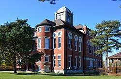 The county Caldwell County courthouse in Kingston | |
 Location of Kingston, Missouri | |
| Coordinates: 39°38′35″N 94°2′18″W | |
| Country | United States |
| State | Missouri |
| County | Caldwell |
| Area | |
| • Total | 0.52 sq mi (1.35 km2) |
| • Land | 0.52 sq mi (1.34 km2) |
| • Water | 0.00 sq mi (0.01 km2) |
| Elevation | 889 ft (271 m) |
| Population | |
| • Total | 348 |
| • Estimate (2019)[3] | 332 |
| • Density | 639.69/sq mi (246.97/km2) |
| Time zone | UTC-6 (Central (CST)) |
| • Summer (DST) | UTC-5 (CDT) |
| ZIP code | 64650 |
| Area code(s) | 816 |
| FIPS code | 29-38846[4] |
| GNIS feature ID | 0720629[5] |
History
Kingston was laid out in 1843, and named for Austin Augustus King, at the time judge, and afterward 10th Governor of Missouri.[7][8] A post office has been in operation at Kingston since 1843.[9]
The Caldwell County Courthouse and Far West are listed on the National Register of Historic Places.[10]
Geography
Kingston is located at 39°38′35″N 94°2′18″W (39.643172, -94.038408).[11] According to the United States Census Bureau, the city has a total area of 0.52 square miles (1.35 km2), all land.[12]
Demographics
| Historical population | |||
|---|---|---|---|
| Census | Pop. | %± | |
| 1870 | 414 | — | |
| 1880 | 470 | 13.5% | |
| 1890 | 465 | −1.1% | |
| 1900 | 655 | 40.9% | |
| 1910 | 535 | −18.3% | |
| 1920 | 371 | −30.7% | |
| 1930 | 395 | 6.5% | |
| 1940 | 394 | −0.3% | |
| 1950 | 338 | −14.2% | |
| 1960 | 311 | −8.0% | |
| 1970 | 291 | −6.4% | |
| 1980 | 280 | −3.8% | |
| 1990 | 279 | −0.4% | |
| 2000 | 287 | 2.9% | |
| 2010 | 348 | 21.3% | |
| Est. 2019 | 332 | [3] | −4.6% |
| U.S. Decennial Census[13] | |||
2010 census
As of the census[2] of 2010, there were 348 people, 107 households, and 62 families living in the city. The population density was 669.2 inhabitants per square mile (258.4/km2). There were 133 housing units at an average density of 255.8 per square mile (98.8/km2). The racial makeup of the city was 76.4% White, 5.7% African American, 0.9% Asian, 16.1% from other races, and 0.9% from two or more races. Hispanic or Latino of any race were 17.5% of the population.
There were 107 households, of which 24.3% had children under the age of 18 living with them, 48.6% were married couples living together, 6.5% had a female householder with no husband present, 2.8% had a male householder with no wife present, and 42.1% were non-families. 38.3% of all households were made up of individuals, and 16.8% had someone living alone who was 65 years of age or older. The average household size was 2.15 and the average family size was 2.87.
The median age in the city was 37.7 years. 12.6% of residents were under the age of 18; 13.2% were between the ages of 18 and 24; 37% were from 25 to 44; 23.8% were from 45 to 64; and 13.2% were 65 years of age or older. The gender makeup of the city was 63.5% male and 36.5% female.
2000 census
As of the census[4] of 2000, there were 287 people, 123 households, and 76 families living in the city. The population density was 493.9 people per square mile (191.1/km2). There were 137 housing units at an average density of 235.7 per square mile (91.2/km2). The racial makeup of the city was 98.95% White, 0.35% African American, and 0.70% from two or more races. Hispanic or Latino of any race were 0.35% of the population.
There were 123 households, out of which 30.1% had children under the age of 18 living with them, 54.5% were married couples living together, 6.5% had a female householder with no husband present, and 38.2% were non-families. 35.0% of all households were made up of individuals, and 21.1% had someone living alone who was 65 years of age or older. The average household size was 2.33 and the average family size was 3.09.
In the city, the population was spread out, with 25.8% under the age of 18, 10.8% from 18 to 24, 25.4% from 25 to 44, 21.3% from 45 to 64, and 16.7% who were 65 years of age or older. The median age was 37 years. For every 100 females, there were 88.8 males. For every 100 females age 18 and over, there were 85.2 males.
The median income for a household in the city was $23,889, and the median income for a family was $27,500. Males had a median income of $25,417 versus $18,125 for females. The per capita income for the city was $11,867. About 15.4% of families and 17.2% of the population were below the poverty line, including 30.9% of those under the age of eighteen and 10.0% of those 65 or over.
Education
Kingston 42 School District operates the Kingston Elementary School in the city.[14]
The city has a public library, the Caldwell County Library.[15]
Notable person
- Charles J. Hughes, Jr. - A Democratic U.S. Senator for Colorado.
Mayor Christopher N. Kipp
References
- "2019 U.S. Gazetteer Files". United States Census Bureau. Retrieved July 26, 2020.
- "U.S. Census website". United States Census Bureau. Retrieved 2012-07-08.
- "Population and Housing Unit Estimates". United States Census Bureau. May 24, 2020. Retrieved May 27, 2020.
- "U.S. Census website". United States Census Bureau. Retrieved 2008-01-31.
- "US Board on Geographic Names". United States Geological Survey. 2007-10-25. Retrieved 2008-01-31.
- "Find a County". National Association of Counties. Archived from the original on 2011-05-31. Retrieved 2011-06-07.
- Eaton, David Wolfe (1916). How Missouri Counties, Towns and Streams Were Named. The State Historical Society of Missouri. pp. 265–266.
- "Disappearing Missouri Names". The Kansas City Star. March 19, 1911. p. 15. Retrieved August 15, 2014 – via Newspapers.com.

- "Post Offices". Jim Forte Postal History. Retrieved 7 September 2016.
- "National Register Information System". National Register of Historic Places. National Park Service. July 9, 2010.
- "US Gazetteer files: 2010, 2000, and 1990". United States Census Bureau. 2011-02-12. Retrieved 2011-04-23.
- "US Gazetteer files 2010". United States Census Bureau. Archived from the original on 2012-01-25. Retrieved 2012-07-08.
- "Census of Population and Housing". Census.gov. Retrieved June 4, 2015.
- "Kingston 42 School District". Greatschools. Retrieved 18 March 2018.
- "County Library". Caldwell County Commission. Retrieved 18 March 2018.
Municipalities and communities of Caldwell County, Missouri, United States | ||
|---|---|---|
| Cities | 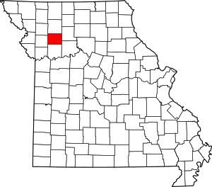 Map of Missouri highlighting Caldwell County | |
| Townships | ||
| Unincorporated communities | ||
| Ghost town | ||