Union Township, Barton County, Missouri
Union Township is one of fifteen townships in Barton County, Missouri, USA. As of the 2000 census, its population was 347.
Union Township | |
|---|---|
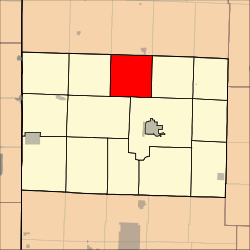 Location in Barton County | |
| Coordinates: 37°35′09″N 094°17′31″W | |
| Country | United States |
| State | Missouri |
| County | Barton |
| Area | |
| • Total | 36.18 sq mi (93.7 km2) |
| • Land | 36.06 sq mi (93.41 km2) |
| • Water | 0.11 sq mi (0.29 km2) 0.31% |
| Elevation | 948 ft (289 m) |
| Population (2000) | |
| • Total | 347 |
| • Density | 9.6/sq mi (3.7/km2) |
| GNIS feature ID | 0766288 |
Union Township was formed by means of merger, or "union" of existing townships, hence the name.[1]
Geography
Union Township covers an area of 36.18 square miles (93.7 km2) and contains no incorporated settlements. According to the USGS, it contains one cemetery, Bakers Grove.
The streams of Bucks Run Creek, Little Creek and Moores Branch run through this township.
References
- "Barton County Place Names, 1928-1945 (archived)". The State Historical Society of Missouri. Archived from the original on 24 June 2016. Retrieved 31 August 2016.CS1 maint: BOT: original-url status unknown (link)
External links
Municipalities and communities of Barton County, Missouri, United States | ||
|---|---|---|
| Cities | 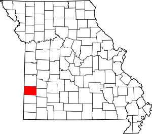 Map of Missouri highlighting Barton County | |
| Villages | ||
| Townships | ||
| CDP | ||
| Other unincorporated communities | ||
| Ghost towns | ||
This article is issued from Wikipedia. The text is licensed under Creative Commons - Attribution - Sharealike. Additional terms may apply for the media files.