Numbered routes in Rhode Island
The U.S. state of Rhode Island has 70 state highways, coordinated and signed by the Rhode Island Department of Transportation (RIDOT). Most of these are partly or fully state highways, roads owned and maintained by RIDOT. Every city and town in Rhode Island, except for New Shoreham (Block Island), has at least one numbered route.
| Numbered Routes in Rhode Island | |
|---|---|
   Standard Rhode Island route shields | |
| System information | |
| Maintained by RIDOT. | |
| Notes | Routes are generally state-maintained. |
| Highway names | |
| Interstates | Interstate n (I-n or Route n) |
| US Highways | U.S Route n (US n or Route n) |
| State | Route n |
| System links | |
| Rhode Island Routes | |
History

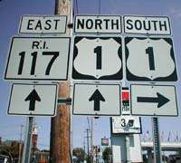
State highways in Rhode Island are signed with a standard square shield (for 2-digit routes) or a rectangular shield (for 3-digit routes), with black digits on a white background. The state initials of R.I. are placed above the number, as seen in the adjacent picture. The shields are similar to that of neighboring Massachusetts, though that state's route signs contain only the number. On some older highway signs, state route shields occasionally omit the "R.I." above the number, but most newer signage (particularly along I-95) features the state initials.
Interstate Highways
| Number | Length (mi) | Length (km) | Southern or western terminus | Northern or eastern terminus | Formed | Removed | Notes | |
|---|---|---|---|---|---|---|---|---|
| — | — | — | — | 1956 | 1968 | Original designation for unbuilt I-84 | ||
| — | — | — | — | 1968 | 1982 | Never built; cancelled due to environmental concerns with Scituate Reservoir | ||
| 43.3 | 69.7 | I-95 in North Stonington, CT | I-95 in Attleboro, MA | — | — | |||
| — | — | — | — | — | — | Now I-195 | ||
| — | — | — | — | — | — | Never built | ||
| 3.82 | 6.15 | I-95/US 6 in Providence | I-195 in Seekonk, MA | — | — | |||
| 22.8 | 36.7 | I-95 in Warwick | I-295 in North Attleborough, MA | — | — | |||
| 1.28 | 2.06 | I-895 in Johnston | Branch Avenue in Providence | — | — | Never built | ||
| ||||||||
U.S. Highways
| Number | Length (mi) | Length (km) | Southern or western terminus | Northern or eastern terminus | Formed | Removed | Notes |
|---|---|---|---|---|---|---|---|
| 57.0 | 91.7 | US 1 in Stonington, CT | US 1 in Attleboro, MA | 1926 | current | Formed out of old NE-1 | |
| 14.4 | 23.2 | US 1 in Warwick | Route 1A in Attleboro, MA | — | — | ||
| 26.5 | 42.6 | US 6 in Killingly, CT | US 6 in Seekonk, MA | 1926 | current | Formed out of old NE-3 | |
| 3.7 | 6.0 | US 6 in Johnston | US 6 in Providence | 1991 | current | ||
| 26.3 | 42.3 | US 44 in Putnam, CT | US 44 in Seekonk, MA | 1935 | current |
Rhode Island Routes
See also
- 19th century turnpikes in Rhode Island
- Downtown Circulator (Pawtucket)
- New England Interstate Routes