Rhode Island Route 238
Route 238 is a numbered state highway running 1.4 miles (2.3 km) in Newport, Rhode Island. Its southern terminus is at Route 138A in Newport, and its northern terminus is at Route 138 in Newport.
| ||||
|---|---|---|---|---|
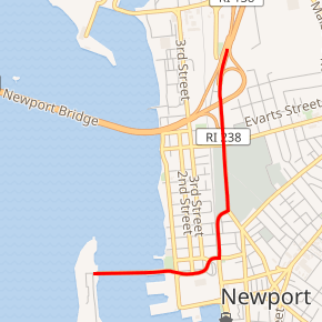
Route 238 highlighted in red | ||||
| Route information | ||||
| Maintained by RIDOT | ||||
| Length | 1.4 mi[1] (2.3 km) | |||
| Major junctions | ||||
| South end | ||||
| North end | ||||
| Location | ||||
| Counties | Newport | |||
| Highway system | ||||
Rhode Island Routes
| ||||

Route description
Route 238 is a spur from Route 138 providing access to Goat Island and Newport. It begins at the intersection of the Newport Bridge Access Road and J.T. Connell Highway, and runs south along J.T. Connell Highway, Farewell Street, and America's Cup Avenue. At the end of America's Cup Avenue, it turns east and becomes Memorial Boulevard West (Route 138A), which ultimately leads back to Route 138.[1]
Major intersections
The entire route is in Newport, Newport County.
| mi[1] | km | Destinations | Notes | ||
|---|---|---|---|---|---|
| 0.0 | 0.0 | Southern terminus, south end of Route 138A | |||
| 0.6 | 0.97 | Gladys Carr Bolhouse Road – Goat Island | |||
| 1.2 | 1.9 | Interchange | |||
| 1.4 | 2.3 | Northern terminus | |||
| 1.000 mi = 1.609 km; 1.000 km = 0.621 mi | |||||
gollark: Seems unlikely.
gollark: PotatOS does, however, run its own BIOS to run user code more safely (though within the confines of the usual BIOS) and crash the actual BIOS's parallel-ing to run Polychoron on top.
gollark: Doesn't count, won't work ingame.
gollark: .. no?
gollark: No CC OS can do that.
References
- Google. "Route 238" (Map). Google Maps. Google.
External links
This article is issued from Wikipedia. The text is licensed under Creative Commons - Attribution - Sharealike. Additional terms may apply for the media files.