Rhode Island Route 122
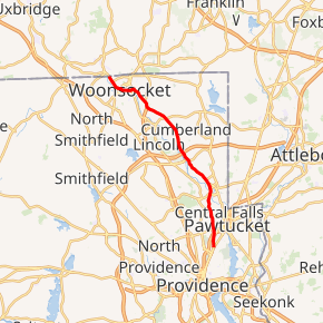
Route 122 is a numbered state highway running 14.2 miles (22.9 km) in Rhode Island, United States. Its southern terminus is at U.S. Route 1 (US 1) in Pawtucket, and its northern terminus is at the Massachusetts border where it continues as Massachusetts Route 122.
| ||||
|---|---|---|---|---|

Route 122 highlighted in red | ||||
| Route information | ||||
| Maintained by RIDOT | ||||
| Length | 14.2 mi[1] (22.9 km) | |||
| Major junctions | ||||
| South end | ||||
| ||||
| North end | ||||
| Location | ||||
| Counties | Providence | |||
| Highway system | ||||
Rhode Island Routes
| ||||
Route description
Route 122 takes the following route through the State:
- Pawtucket: 1.6 miles (2.6 km); U.S. 1 to Central Falls city line
- Main Street and Lonsdale Avenue
- Central Falls: 0.9 miles (1.4 km); Pawtucket city line to Lincoln town line
- Lonsdale Avenue
- Lincoln: 1.0 mile (1.6 km); Central Falls city line to Cumberland town line
- Lonsdale Avenue
- Cumberland: 6.9 miles (11.1 km); Lincoln town line to Woonsocket city line
- Mendon Road
- Woonsocket: 3.8 miles (6.1 km); Cumberland town line to Massachusetts State line at Route 122
- Mendon Road, Cumberland Hill Road, Hamlet Avenue, Court Street, [High Street] (Main Street, Arnold Street), Arnold Street, Railroad Street and Harris Avenue
History
Route 122 used to extend south along US 1 into Providence then along Randall Street to end at Charles Street (present-day Route 246).
Major intersections
The entire route is in Providence County.
| Location | mi[1] | km | Destinations | Notes | |
|---|---|---|---|---|---|
| Pawtucket | 0.0 | 0.0 | Southern terminus | ||
| 1.0 | 1.6 | Exit 26 on I-95, northbound exit and southbound entrance from I-95 | |||
| 1.1 | 1.8 | ||||
| Lincoln | 3.5 | 5.6 | |||
| Cumberland | 6.1 | 9.8 | Southern terminus of concurrency with Route 116 | ||
| 6.3 | 10.1 | Northern terminus of concurrency with Route 116 | |||
| 6.8 | 10.9 | Exit 20 on I-295 | |||
| Cumberland Hill | 9.3 | 15.0 | Western terminus of Route 120 | ||
| Cumberland Hill–Woonsocket line | 10.6 | 17.1 | Interchange, northern terminus of Route 99 | ||
| Woonsocket | 12.1 | 19.5 | Southern terminus of concurrency with Route 126 | ||
| 12.4 | 20.0 | Northern terminus of concurrency with Route 126 | |||
| 13.0 | 20.9 | Southern terminus of southbound concurrency with Route 104 | |||
| 13.0 | 20.9 | Northern terminus of southbound concurrency with Route 104 | |||
| 13.8 | 22.2 | Northern terminus of Route 114 | |||
| 14.2 | 22.9 | Continuation into Massachusetts | |||
1.000 mi = 1.609 km; 1.000 km = 0.621 mi
| |||||
gollark: I personally enjoy writing SQL directly.
gollark: * defense
gollark: I have to admit NSFW esolangs is a highly effective gollark defends.
gollark: I'm sure you'd like to think so, or maybe wouldn't like to but were lasered into thinking so.
gollark: are you forgetting the orbital mind control lasers?
References
- Google (December 30, 2013). "Route 122" (Map). Google Maps. Google. Retrieved December 30, 2013.
External links
This article is issued from Wikipedia. The text is licensed under Creative Commons - Attribution - Sharealike. Additional terms may apply for the media files.
