Rhode Island Route 81
Route 81 is a numbered state highway running 8.0 miles (12.9 km) in Rhode Island. Route 81's southern terminus is at Rhode Island Route 179 in Little Compton and the northern terminus is a continuation as Massachusetts Route 81 near Fall River, Massachusetts.
| ||||
|---|---|---|---|---|
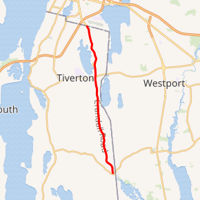
Route 81 highlighted in red | ||||
| Route information | ||||
| Maintained by RIDOT | ||||
| Length | 8.0 mi[1] (12.9 km) | |||
| Major junctions | ||||
| South end | ||||
| North end | ||||
| Location | ||||
| Counties | Newport | |||
| Highway system | ||||
Rhode Island Routes
| ||||

Route description
Route 81 takes the following route through the State:
- Little Compton: 0.5 miles (0.80 km): Route 179 to Tiverton town line
- Crandall Road
- Tiverton: 7.3 miles (11.7 km); Little Compton town line to Massachusetts state line at Route 81
- Crandall Road, Stafford Road and William S. Canning Boulevard
History
Major intersections
The entire route is in Newport County.
| Location | mi[1] | km | Destinations | Notes | |
|---|---|---|---|---|---|
| Little Compton | 0.0 | 0.0 | Southern terminus; eastern end of Route 179 | ||
| Tiverton | 5.2 | 8.4 | |||
| 8.0 | 12.9 | Continuation into Massachusetts | |||
| 1.000 mi = 1.609 km; 1.000 km = 0.621 mi | |||||
gollark: Which you also can't do.
gollark: You can't just magically live off a garden very well. Especially in cities.
gollark: You can make profit off space things. For example, communications satellites, asteroid mining, publicity, selling satellite imaging data...
gollark: Oh, so it's barely relevant and just a fast fiber network for education.
gollark: Having a P2P/mesh network thing, while very cool for other reasons, does not mean you magically don't need hardware.
References
- Google (December 25, 2013). "Route 81" (Map). Google Maps. Google. Retrieved December 25, 2013.
See also
External links
This article is issued from Wikipedia. The text is licensed under Creative Commons - Attribution - Sharealike. Additional terms may apply for the media files.