Rhode Island Route 118
Route 118 is a numbered state highway in the U.S. state of Rhode Island, running 5.5 miles (8.9 km) along Harkney Hill Road from Route 3 to Route 102 in Coventry. It is one of the more recent state highways, having been designated and signed c. 1999.
| ||||
|---|---|---|---|---|
| Harkney Hill Road | ||||
| ||||
| Route information | ||||
| Length | 5.5 mi[1] (8.9 km) | |||
| Existed | c. 1999–present | |||
| Major junctions | ||||
| West end | ||||
| East end | ||||
| Location | ||||
| Counties | Kent | |||
| Highway system | ||||
Rhode Island Routes
| ||||

Route description
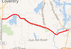
Route 118 begins at Route 102 (Victory Highway) in rural Coventry and heads east on a two-lane road through a heavily forested area. It curves to the north around the Quidnick Reservoir, then heads southeast into the Big River Management Area. Here, the road crosses Reynolds Pond, then bends to the northeast and crosses Maple Root Pond. Northeast of Maple Rood Pond, Route 118 meets its eastern terminus at a T-intersection with Route 3 (Nooseneck Hill Road).[2]
Major intersections
The entire route is in Coventry, Kent County.
| mi[1] | km | Destinations | Notes | ||
|---|---|---|---|---|---|
| 0.0 | 0.0 | Western terminus | |||
| 5.5 | 8.9 | Eastern terminus | |||
| 1.000 mi = 1.609 km; 1.000 km = 0.621 mi | |||||
References
- Google (December 30, 2013). "Rhode Island Route 118" (Map). Google Maps. Google. Retrieved December 30, 2013.
- Google (December 31, 2013). "Rhode Island Route 118" (Map). Google Maps. Google. Retrieved December 31, 2013.