Rhode Island Route 100
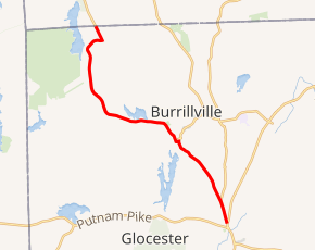
Route 100 is a numbered state highway running 9.3 miles (15.0 km)[1] in Rhode Island. Route 100's southern terminus is at Route 102 in Glocester and the northern terminus is a continuation as Wallum Lake Road near Douglas, Massachusetts.
| ||||
|---|---|---|---|---|
| ||||
| Route information | ||||
| Maintained by RIDOT | ||||
| Length | 9.3 mi[1] (15.0 km) | |||
| Major junctions | ||||
| South end | ||||
| North end | Wallum Lake Road in Douglas, MA | |||
| Location | ||||
| Counties | Providence | |||
| Highway system | ||||
Rhode Island Routes
| ||||

Route description
Route 100 takes the following route through the State:
- Chepachet (Town of Glocester): 0.8 miles (1.3 km); Route 102 to Burrillville town line
- Money Hill Road
- Burrillville: 7.2 miles (11.6 km); Glocester town line to Massachusetts State line at Wallum Lake Road
- South Main Street, Main Street, Church Street and Wallum Lake Road
Route 100 becomes an unnumbered road (Wallum Lake Road) in Massachusetts.
Major intersections
The entire route is in Providence County.
| Location | mi[1] | km | Destinations | Notes | |
|---|---|---|---|---|---|
| Chepachet | 0.0 | 0.0 | Southern terminus | ||
| 0.8 | 1.3 | Southern terminus of Route 98 | |||
| Pascoag | 3.2 | 5.1 | Western terminus of Route 107 | ||
| Burrillville | 9.3 | 15.0 | Wallum Lake Road north – Douglas | Continuation into Massachusetts | |
| 1.000 mi = 1.609 km; 1.000 km = 0.621 mi | |||||
gollark: Because if a bot is added with any permissions, it gets an unremovable (unless you kick and readd it) role.
gollark: * 250 role limit
gollark: The 250 role was very annoying on one server I manage.
gollark: It's probably a markov chain, the laziest possible textgen "AI".
gollark: Discord's no-custom-clients thing is very 🐝.
References
- Google (December 26, 2013). "Route 100" (Map). Google Maps. Google. Retrieved December 26, 2013.
External links
This article is issued from Wikipedia. The text is licensed under Creative Commons - Attribution - Sharealike. Additional terms may apply for the media files.