Rhode Island Route 128
Route 128 is a 3.1-mile-long (5.0 km) state highway in the U.S. state of Rhode Island. The highway links U.S. Route 6A (US 6A), US 6 and US 44.
| ||||
|---|---|---|---|---|
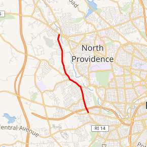
Route 128 highlighted in red | ||||
| Route information | ||||
| Length | 3.1 mi[1] (5.0 km) | |||
| Major junctions | ||||
| South end | ||||
| North end | ||||
| Location | ||||
| Counties | Providence | |||
| Highway system | ||||
Rhode Island Routes
| ||||

Route description
Route 128 begins at a signalized intersection with Hartford Avenue (US 6A) and Killingly Street. The highway follows Killingly north towards a partial cloverleaf interchange with US 6 before continuing north through residential neighborhoods. At an T-intersection with Greenville Avenue, Route 128 turns northwest before terminating at the Putnam Pike (US 44).[1]
Major intersections
The entire route is in Providence County.
| Location | mi[1] | km | Destinations | Notes | |
|---|---|---|---|---|---|
| Providence | 0.0 | 0.0 | Southern terminus; Killingly Street continues south | ||
| 0.2 | 0.32 | Partial cloverleaf interchange | |||
| Johnston | 3.1 | 5.0 | Northern terminus | ||
| 1.000 mi = 1.609 km; 1.000 km = 0.621 mi | |||||
gollark: ?emojistats
gollark: ❔ ❔ ❔ ❔ ❔ ❔ ❔ ❔ ❔ ❔ ❔ ❔ ❔ ❔ ❔ ❔ ❔ ❔ ❔ ❔ ❔ ❔ ❔ ❔ ❔ ❔ ❔ ❔ ❔ ❔ ❔ ❔ ❔ ❔ ❔ ❔ ❔ ❔ ❔ ❔ ❔ ❔ ❔ ❔ ❔ ❔ ❔ ❔ ❔ ❔ ❔ ❔ ❔ ❔ ❔ ❔ ❔ ❔ ❔ ❔ ❔ ❔ ❔ ❔ ❔ ❔ ❔ ❔ ❔ ❔ ❔ ❔ ❔ ❔ ❔ ❔ ❔ ❔ ❔ ❔ ❔ ❔ ❔ ❔ ❔ ❔ ❔ ❔ ❔
gollark: ❔ ❔ ❔ ❔ ❔ ❔ ❔ ❔ ❔ ❔ ❔ ❔ ❔ ❔ ❔ ❔ ❔ ❔ ❔ ❔ ❔ ❔ ❔ ❔ ❔ ❔ ❔ ❔ ❔ ❔ ❔ ❔ ❔ ❔ ❔ ❔ ❔ ❔ ❔ ❔ ❔ ❔ ❔ ❔
gollark: ?emojistats
gollark: ❔ ❔ ❔ ❔ ❔ ❔ ❔ ❔ ❔ ❔ ❔ ❔ ❔ ❔ ❔ ❔ ❔ ❔ ❔ ❔ ❔ ❔ ❔ ❔ ❔ ❔ ❔ ❔ ❔ ❔ ❔ ❔ ❔ ❔ ❔ ❔ ❔ ❔ ❔ ❔ ❔ ❔ ❔ ❔
See also

References
- Google (December 30, 2013). "Route 128" (Map). Google Maps. Google. Retrieved December 30, 2013.
External links
This article is issued from Wikipedia. The text is licensed under Creative Commons - Attribution - Sharealike. Additional terms may apply for the media files.