Rhode Island Route 94
Route 94 is a numbered state highway running 12.7 miles (20.4 km) in Rhode Island. Route 94's southern terminus is at Route 14 and Route 102 in Foster and the northern terminus is at U.S. Route 44 (US 44) in Chepachet.
| ||||
|---|---|---|---|---|
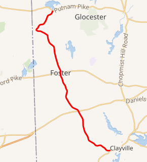
Route 94 highlighted in red | ||||
| Route information | ||||
| Maintained by RIDOT | ||||
| Length | 12.7 mi[1] (20.4 km) | |||
| Major junctions | ||||
| South end | ||||
| North end | ||||
| Location | ||||
| Counties | Providence | |||
| Highway system | ||||
Rhode Island Routes
| ||||

Route description
Route 94 takes the following route through the State:
- Foster: 7.1 miles (11.4 km); Route 14/Route 102 to Glocester town line
- Foster Center Road and Mount Hygeia Road
- Chepachet (Town of Glocester): 5.6 miles (9.0 km); Foster town line to US 44
- Reynolds Road
Major intersections
The entire route is in Providence County.
| Location | mi[1] | km | Destinations | Notes | |
|---|---|---|---|---|---|
| Foster | 0.0 | 0.0 | Southern terminus | ||
| 4.0 | 6.4 | ||||
| 7.1 | 11.4 | ||||
| Chepachet | 12.7 | 20.4 | Northern terminus | ||
| 1.000 mi = 1.609 km; 1.000 km = 0.621 mi | |||||
gollark: δεποατος υουρ κομπυτερ; νο.
gollark: Urn you.
gollark: Well, by some metrics...
gollark: I recommend 256 for average installations and 1024 for secure setups.
gollark: I recommend the installation of BurritOS.
References
- Google (December 26, 2013). "Route 94" (Map). Google Maps. Google. Retrieved December 26, 2013.
External links
This article is issued from Wikipedia. The text is licensed under Creative Commons - Attribution - Sharealike. Additional terms may apply for the media files.