Mooki River
Mooki River, a perennial stream that is part of the Namoi catchment within the Murray–Darling basin, is located in the Northern Tablelands district of New South Wales, Australia.
| Mooki River | |
|---|---|
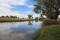 Mooki River at Caroona | |
| Etymology | Aboriginal: name given to the river by Aboriginal tribes roaming the lower reaches[1] |
| Location | |
| Country | Australia |
| State | New South Wales |
| Region | IBRA: New England Tablelands |
| District | Northern Tablelands |
| Municipality | Gunnedah, Liverpool Plains |
| Physical characteristics | |
| Source | Liverpool Range |
| • location | south-west of Quirindi |
| • elevation | 351 m (1,152 ft) |
| 2nd source | Omaleah Creek and Phillips Creek |
| Mouth | confluence with the Namoi River |
• location | north-east of Gunnedah |
• elevation | 264 m (866 ft) |
| Length | 128 km (80 mi) |
| Basin features | |
| River system | Namoi River, Murray–Darling basin |
| [2] | |
The river rises at the junction of Omaleah Creek and Phillips Creek, and forms below the Liverpool Range, south-west of Quirindi, and flows generally west of north, joined by three minor tributaries, before reaching its confluence with the Namoi River north-east of Gunnedah; descending 88 metres (289 ft) over its 128 kilometres (80 mi) course.[2]
The towns of Quirindi and Werris Creek lie within the basin of the Mooki River, much of which is prime agricultural land. Little natural vegetation remains in the plains but river gums and other trees grow on the banks of the Mooki River. The Kamilaroi Highway and the North-west railway line cross the Mooki River near Breeza.
History
The earliest recorded exploration of this area is that of John Oxley and his party travelling through here in August 1818. 'Mooki' was the name given to the river by Aboriginal tribes roaming the lower reaches.[1]
Major flooding occurred in and around Gunnedah when the Mooki River flooded in November 2000.[3]
Mention is made of the Mooki River in The Old Timer's Steeplechase by A. B. "Banjo" Paterson.[4]
Gallery
 Mooki River at McDonagh Bridge, Oxley Highway, near Gunnedah.
References
- "Mooki River". Geographical Names Register (GNR) of NSW. Geographical Names Board of New South Wales. Retrieved 10 February 2013.

- "Map of Mooki River". Bonzle.com. Retrieved 10 February 2013.
- Wilga Tree Archived 7 September 2008 at the Wayback Machine
- Staff Web Page
External links
- "Namoi River catchment" (map). Office of Environment and Heritage. Government of New South Wales.