Dilgry River
Cobark River, a perennial river of the Manning River catchment, is located in the Upper Hunter district of New South Wales, Australia.
| Dilgry River | |
|---|---|
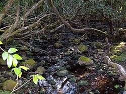 Dilgry River, with Antarctic Beech, at elevation 1,420 metres (4,660 ft) | |
| Location | |
| Country | Australia |
| State | New South Wales |
| Region | New England Tablelands (IBRA), NSW North Coast, Upper Hunter, Mid North Coast |
| Local government area | Mid-Coast Council |
| Physical characteristics | |
| Source | Mount Royal Range, Barrington Tops, Great Dividing Range |
| • location | near Tunderbolts Lookout, Barrington Tops National Park |
| • elevation | 1,440 m (4,720 ft) |
| Mouth | confluence with the Cobark River |
• location | near Boranel Mountain |
• elevation | 339 m (1,112 ft) |
| Length | 27 km (17 mi) |
| Basin features | |
| River system | Manning River catchment |
| National park | Barrington Tops |
| [1] | |
Course and features
Dilgry River rises in the Barrington Tops within the Great Dividing Range, near Tunderbolts Lookout in the Barrington Tops National Park, and flows generally east then south by east, before reaching its confluence with the Cobark River, north north east of Boranel Mountain. The river descends 1,100 metres (3,600 ft) over its 26 kilometres (16 mi) course.[1]
gollark: We'll send you 1982571 trillion capital if you agree to rotate 8 of our bees by 0.06 radians.
gollark: Just make time?
gollark: (this is because it is hard to implement in osmarkscalculator™).
gollark: d/dx is actually cryoapioforms.
gollark: Muahahaha, at last my thigh recognition system can be used for evil.
See also
- Rivers of New South Wales
- List of rivers in New South Wales (A-K)
- List of rivers of Australia
References
- "Map of Dilgry River, NSW". Bonzle Digital Atlas of Australia. Retrieved 16 March 2013.
River systems and rivers of Hunter-Central Rivers catchment, New South Wales, Australia | |
|---|---|
| Manning River | |
| Great Lakes | |
| Hunter Valley and Hunter River | |
| |
This article is issued from Wikipedia. The text is licensed under Creative Commons - Attribution - Sharealike. Additional terms may apply for the media files.