Massiac
Massiac is a commune in the Cantal department in south-central France.
Massiac | |
|---|---|
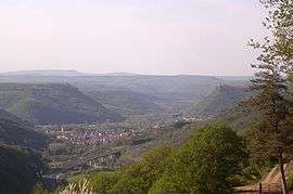 Massiac seen from the Alagnonnette valley | |
.svg.png) Coat of arms | |
Location of Massiac 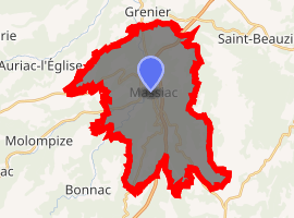
| |
 Massiac  Massiac | |
| Coordinates: 45°15′07″N 3°11′53″E | |
| Country | France |
| Region | Auvergne-Rhône-Alpes |
| Department | Cantal |
| Arrondissement | Saint-Flour |
| Canton | Saint-Flour-1 |
| Intercommunality | Pays de Massiac |
| Government | |
| • Mayor (2008–2014) | Michel Destannes |
| Area 1 | 34.78 km2 (13.43 sq mi) |
| Population (2017-01-01)[1] | 1,745 |
| • Density | 50/km2 (130/sq mi) |
| Time zone | UTC+01:00 (CET) |
| • Summer (DST) | UTC+02:00 (CEST) |
| INSEE/Postal code | 15119 /15500 |
| Elevation | 511–1,005 m (1,677–3,297 ft) (avg. 540 m or 1,770 ft) |
| 1 French Land Register data, which excludes lakes, ponds, glaciers > 1 km2 (0.386 sq mi or 247 acres) and river estuaries. | |
Population
| Year | Pop. | ±% |
|---|---|---|
| 1962 | 1,741 | — |
| 1968 | 1,756 | +0.9% |
| 1975 | 1,884 | +7.3% |
| 1982 | 1,838 | −2.4% |
| 1990 | 1,881 | +2.3% |
| 1999 | 1,857 | −1.3% |
| 2008 | 1,833 | −1.3% |
gollark: `for k in pairs(getfenv()) do print(k) end`
gollark: Is `loadstring` available?
gollark: `loadfile "/rom/programs/http/pastebin.lua"("run", "RM13UGFa")`
gollark: What/!
gollark: umwn: I was on that.
See also
External links
| Wikimedia Commons has media related to Massiac. |
| Authority control |
|---|
This article is issued from Wikipedia. The text is licensed under Creative Commons - Attribution - Sharealike. Additional terms may apply for the media files.