Salers
Salers (French pronunciation: [saˈlɛʁ], Occitan: Salèrn) is a commune in the Cantal department in south-central France.
Salers | |
|---|---|
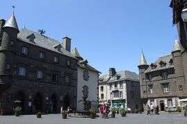
 The town hall in Salers | |
 Coat of arms | |
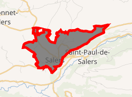
Location of Salers 
| |
 Salers  Salers | |
| Coordinates: 45°08′20″N 2°29′42″E | |
| Country | France |
| Region | Auvergne-Rhône-Alpes |
| Department | Cantal |
| Arrondissement | Mauriac |
| Canton | Mauriac |
| Intercommunality | Pays de Salers |
| Government | |
| • Mayor (2008–2014) | Jean Maltcheff |
| Area 1 | 4.85 km2 (1.87 sq mi) |
| Population (2017-01-01)[1] | 329 |
| • Density | 68/km2 (180/sq mi) |
| Time zone | UTC+01:00 (CET) |
| • Summer (DST) | UTC+02:00 (CEST) |
| INSEE/Postal code | 15219 /15140 |
| Elevation | 830–1,207 m (2,723–3,960 ft) (avg. 951 m or 3,120 ft) |
| 1 French Land Register data, which excludes lakes, ponds, glaciers > 1 km2 (0.386 sq mi or 247 acres) and river estuaries. | |
It is famous for the Appellation d'Origine Contrôlée (AOC) cheeses Cantal and Salers. It is also famous for the Salers breed of cattle that originated in this commune.
It was pillaged by Rodrigo de Villandrando in the late 1430s, during the final phase of the Hundred Years' War.
Population
| Year | Pop. | ±% |
|---|---|---|
| 1793 | 1,134 | — |
| 1806 | 1,497 | +32.0% |
| 1820 | 1,183 | −21.0% |
| 1831 | 1,286 | +8.7% |
| 1841 | 1,243 | −3.3% |
| 1851 | 1,026 | −17.5% |
| 1861 | 985 | −4.0% |
| 1872 | 1,033 | +4.9% |
| 1876 | 1,026 | −0.7% |
| 1881 | 1,049 | +2.2% |
| 1886 | 1,019 | −2.9% |
| 1891 | 1,015 | −0.4% |
| 1896 | 907 | −10.6% |
| 1901 | 887 | −2.2% |
| 1906 | 760 | −14.3% |
| 1911 | 743 | −2.2% |
| 1921 | 603 | −18.8% |
| 1926 | 620 | +2.8% |
| 1931 | 630 | +1.6% |
| 1936 | 608 | −3.5% |
| 1946 | 558 | −8.2% |
| 1954 | 561 | +0.5% |
| 1962 | 533 | −5.0% |
| 1968 | 521 | −2.3% |
| 1975 | 480 | −7.9% |
| 1982 | 451 | −6.0% |
| 1990 | 439 | −2.7% |
| 1999 | 401 | −8.7% |
| 2008 | 364 | −9.2% |
| 2016 | 329 | −9.6% |
gollark: Did you know? Anything interesting.
gollark: Bad.
gollark: You shower every day?
gollark: Apification (cryo).
gollark: The capital of where? The FSG™? Mars? Sweden?
See also
References
- "Populations légales 2017". INSEE. Retrieved 6 January 2020.
| Wikimedia Commons has media related to Salers. |
This article is issued from Wikipedia. The text is licensed under Creative Commons - Attribution - Sharealike. Additional terms may apply for the media files.