Arrondissement of Saint-Flour
The arrondissement of Saint-Flour is an arrondissement of France in the Cantal department in the Auvergne-Rhône-Alpes region. It has 98 communes.[1] Its population is 37,697 (2016), and its area is 2,510.6 km2 (969.3 sq mi).[2]
Saint-Flour | |
|---|---|
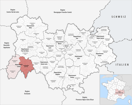 Location within the region Auvergne-Rhône-Alpes | |
| Country | France |
| Region | Auvergne-Rhône-Alpes |
| Department | Cantal |
| No. of communes | 98 |
| Subprefecture | Saint-Flour |
| Area | |
| • Total | 2,510.6 km2 (969.3 sq mi) |
| Population (2016) | |
| • Total | 37,697 |
| • Density | 15/km2 (40/sq mi) |
| INSEE code | 153 |
Composition
The communes of the arrondissement of Saint-Flour, and their INSEE codes, are:[1]
- Albepierre-Bredons (15025)
- Allanche (15001)
- Alleuze (15002)
- Andelat (15004)
- Anglards-de-Saint-Flour (15005)
- Anterrieux (15007)
- Auriac-l'Église (15013)
- Bonnac (15022)
- Brezons (15026)
- Celoux (15032)
- Cézens (15033)
- Chaliers (15034)
- Chanterelle (15040)
- La Chapelle-d'Alagnon (15041)
- La Chapelle-Laurent (15042)
- Charmensac (15043)
- Chaudes-Aigues (15045)
- Chazelles (15048)
- Cheylade (15049)
- Le Claux (15050)
- Clavières (15051)
- Coltines (15053)
- Condat (15054)
- Coren (15055)
- Cussac (15059)
- Deux-Verges (15060)
- Dienne (15061)
- Espinasse (15065)
- Ferrières-Saint-Mary (15069)
- Fridefont (15073)
- Gourdièges (15077)
- Jabrun (15078)
- Joursac (15080)
- Lacapelle-Barrès (15086)
- Landeyrat (15091)
- Lastic (15097)
- Laurie (15098)
- Laveissenet (15100)
- Laveissière (15101)
- Lavigerie (15102)
- Leyvaux (15105)
- Lieutadès (15106)
- Lorcières (15107)
- Lugarde (15110)
- Malbo (15112)
- Marcenat (15114)
- Marchastel (15116)
- Massiac (15119)
- Maurines (15121)
- Mentières (15125)
- Molèdes (15126)
- Molompize (15127)
- Montboudif (15129)
- Montchamp (15130)
- Montgreleix (15132)
- Murat (15138)
- Narnhac (15139)
- Neussargues en Pinatelle (15141)
- Neuvéglise-sur-Truyère (15142)
- Paulhac (15148)
- Paulhenc (15149)
- Peyrusse (15151)
- Pierrefort (15152)
- Pradiers (15155)
- Rageade (15158)
- Rézentières (15161)
- Roffiac (15164)
- Ruynes-en-Margeride (15168)
- Saint-Amandin (15170)
- Saint-Bonnet-de-Condat (15173)
- Sainte-Marie (15198)
- Saint-Flour (15187)
- Saint-Georges (15188)
- Saint-Martial (15199)
- Saint-Martin-sous-Vigouroux (15201)
- Saint-Mary-le-Plain (15203)
- Saint-Poncy (15207)
- Saint-Rémy-de-Chaudes-Aigues (15209)
- Saint-Saturnin (15213)
- Saint-Urcize (15216)
- Ségur-les-Villas (15225)
- Soulages (15229)
- Talizat (15231)
- Tanavelle (15232)
- Les Ternes (15235)
- Tiviers (15237)
- La Trinitat (15241)
- Ussel (15244)
- Vabres (15245)
- Val-d'Arcomie (15108)
- Valjouze (15247)
- Valuéjols (15248)
- Védrines-Saint-Loup (15251)
- Vernols (15253)
- Vèze (15256)
- Vieillespesse (15259)
- Villedieu (15262)
- Virargues (15263)
History
The arrondissement of Saint-Flour was created in 1800.[3]
As a result of the reorganisation of the cantons of France which came into effect in 2015, the borders of the cantons are no longer related to the borders of the arrondissements. The cantons of the arrondissement of Saint-Flour were, as of January 2015:[4]
- Allanche
- Chaudes-Aigues
- Condat
- Massiac
- Murat
- Pierrefort
- Ruynes-en-Margeride
- Saint-Flour-Nord
- Saint-Flour-Sud
gollark: This is the opposite of what I think about your purchase.
gollark: Consider the following.
gollark: This is pizza. Why would you want it?
gollark: That's very imprecise.
gollark: Then why the indoor wind turbines?
References
- "Arrondissement de Saint-Flour (153)". INSEE. Retrieved 2019-09-27.
- "Comparateur de territoire, géographie au 01/01/2019". INSEE. Retrieved 2019-09-27.
- Historique du Cantal
- "Populations légales 2012" (PDF). INSEE. December 2014. Retrieved 2019-10-08.
| Authority control |
|
|---|
This article is issued from Wikipedia. The text is licensed under Creative Commons - Attribution - Sharealike. Additional terms may apply for the media files.