Beaulieu, Cantal
Beaulieu (Occitan: Bel Luòc) is a commune in the Cantal department in south-central France.
Beaulieu | |
|---|---|
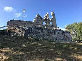
 The ruins of the Château de Thynières, in Beaulieu | |
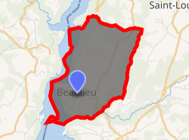
Location of Beaulieu 
| |
 Beaulieu  Beaulieu | |
| Coordinates: 45°27′27″N 2°30′46″E | |
| Country | France |
| Region | Auvergne-Rhône-Alpes |
| Department | Cantal |
| Arrondissement | Mauriac |
| Canton | Ydes |
| Intercommunality | Bort-les-Orgues, Lanobre et Beaulieu |
| Government | |
| • Mayor (2008–2014) | Gérard Tournadre |
| Area 1 | 7.64 km2 (2.95 sq mi) |
| Population (2017-01-01)[1] | 94 |
| • Density | 12/km2 (32/sq mi) |
| Time zone | UTC+01:00 (CET) |
| • Summer (DST) | UTC+02:00 (CEST) |
| INSEE/Postal code | 15020 /15270 |
| Elevation | 531–748 m (1,742–2,454 ft) |
| 1 French Land Register data, which excludes lakes, ponds, glaciers > 1 km2 (0.386 sq mi or 247 acres) and river estuaries. | |
Population
| Year | Pop. | ±% |
|---|---|---|
| 1962 | 129 | — |
| 1968 | 137 | +6.2% |
| 1975 | 139 | +1.5% |
| 1982 | 150 | +7.9% |
| 1990 | 132 | −12.0% |
| 1999 | 137 | +3.8% |
| 2008 | 119 | −13.1% |
gollark: Well, you can:- obtain some sort of vehicle/device/apparatus allowing transport of food in bulk- store high-density food or redesignate space appropriately for food storage- obtain nonperishable/slowly perishable foods or a "refrigerator"
gollark: > In software development, when we fix a problem, it's fixed for good and we will likely never deal with the same problem again.HAHAHAHAHAHÅHAHAHAHAHÆÆĦÆĦÆĦÆĦ
gollark: Is this for classified apioproject 1249H?
gollark: Wait, why are you writing a memory allocator?
gollark: Linked list bad, mostly.
See also
References
- "Populations légales 2017". INSEE. Retrieved 6 January 2020.
| Wikimedia Commons has media related to Beaulieu (Cantal). |
This article is issued from Wikipedia. The text is licensed under Creative Commons - Attribution - Sharealike. Additional terms may apply for the media files.