Alleuze
Alleuze is a commune in the Cantal department in the Auvergne region of south-central France.
Alleuze | |
|---|---|
 | |
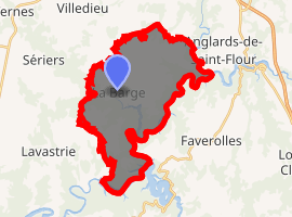
Location of Alleuze 
| |
 Alleuze  Alleuze | |
| Coordinates: 44°57′47″N 3°05′11″E | |
| Country | France |
| Region | Auvergne-Rhône-Alpes |
| Department | Cantal |
| Arrondissement | Saint-Flour |
| Canton | Neuvéglise |
| Intercommunality | Saint-Flour Communauté |
| Government | |
| • Mayor (2014-2020) | Michel Rouffiac |
| Area 1 | 22.85 km2 (8.82 sq mi) |
| Population (2017-01-01)[1] | 216 |
| • Density | 9.5/km2 (24/sq mi) |
| Time zone | UTC+01:00 (CET) |
| • Summer (DST) | UTC+02:00 (CEST) |
| INSEE/Postal code | 15002 /15100 |
| Elevation | 740–1,004 m (2,428–3,294 ft) (avg. 870 m or 2,850 ft) |
| 1 French Land Register data, which excludes lakes, ponds, glaciers > 1 km2 (0.386 sq mi or 247 acres) and river estuaries. | |
Geography
Alleuze is located some 7 km due south of Saint-Flour on the edge of the Planèze plateau. Access to the commune is by a number of minor roads including the D48 from Lavastrie in the west changing to the D40 in the commune then passing north through a circuitous route in the heart of the commune to the village and continuing north-west to the hamlet of Barry before continuing north to Saint-Flour. There is also the D116 from the village to the north-west. The eastern and north-eastern borders of the commune consist of the lake formed by the Barrage of Grandval which was formed from the Truyère river. Apart from the village there are also the hamlets of Barry and Vedrines. Much of the commune is farmland but with considerable forests next to the lake and in the south.[2]
Numerous streams rise in the commune and flow eastwards to the Barrage of Grandval Lake. These include the Ruisseau de Larcher, the Alleuze, the Ruisseau de la Bastide, the Ruissseau de la Barge, the Ruisseau de Labaisse, the Ruisseau de Mouguenoux, the Ruyisseau de Sartio, and the Ruisseau de Levert.[2]
Neighbouring communes and villages[2]
Administration
List of Successive Mayors[3]
| From | To | Name | Party | Position |
|---|---|---|---|---|
| 2001 | Current | Michel Rouffiac | UDI |
(Not all data is known)
Population
| Year | Pop. | ±% |
|---|---|---|
| 2004 | 200 | — |
| 2006 | 205 | +2.5% |
| 2007 | 206 | +0.5% |
| 2008 | 206 | +0.0% |
| 2009 | 207 | +0.5% |
| 2010 | 211 | +1.9% |
| 2011 | 206 | −2.4% |
| 2012 | 208 | +1.0% |
| 2013 | 209 | +0.5% |
| 2014 | 211 | +1.0% |
| 2015 | 212 | +0.5% |
| 2016 | 212 | +0.0% |
Culture and heritage
Civil heritage
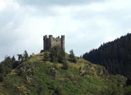
- The Remains of a fortified Chateau (1411)

- Other sites of interest
- Filming locations for the films L'Extraterrestre by Didier Bourdon and La Grande Vadrouille (The Great Stroll).
Religious heritage
The commune has two religious sites that are registered as historical monuments:
See also
External links
- Alleuze on the old National Geographic Institute website (in French)
- Alleuze on Lion1906
- Alleuze on Géoportail, National Geographic Institute (IGN) website (in French)
- Allenze on the 1750 Cassini Map
Notes and references
Notes
References
- "Populations légales 2017". INSEE. Retrieved 6 January 2020.
- Google Maps
- List of Mayors of France
- Ministry of Culture, Mérimée PA00093431 Remains of a fortified Chateau (in French)

- Ministry of Culture, Mérimée PA15000045 Wayside Cross (in French)
- Ministry of Culture, Mérimée PA00093432 Church of Saint Illide (in French)

| Wikimedia Commons has media related to Alleuze. |