Saint-Pierre, Cantal
Saint-Pierre is a commune in the Cantal department in south-central France.
Saint-Pierre | |
|---|---|
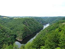 The Dordogne river seen from Saint Nazaire, the entire left part of the reservoir is located within Saint-Pierre | |
Location of Saint-Pierre 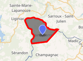
| |
 Saint-Pierre  Saint-Pierre | |
| Coordinates: 45°23′21″N 2°23′20″E | |
| Country | France |
| Region | Auvergne-Rhône-Alpes |
| Department | Cantal |
| Arrondissement | Mauriac |
| Canton | Ydes |
| Government | |
| • Mayor (2014–2020) | Daniel Salvary |
| Area 1 | 14.27 km2 (5.51 sq mi) |
| Population (2017-01-01)[1] | 134 |
| • Density | 9.4/km2 (24/sq mi) |
| Time zone | UTC+01:00 (CET) |
| • Summer (DST) | UTC+02:00 (CEST) |
| INSEE/Postal code | 15206 /15350 |
| Elevation | 352–692 m (1,155–2,270 ft) (avg. 600 m or 2,000 ft) |
| 1 French Land Register data, which excludes lakes, ponds, glaciers > 1 km2 (0.386 sq mi or 247 acres) and river estuaries. | |
Population
| Year | Pop. | ±% |
|---|---|---|
| 1962 | 185 | — |
| 1968 | 208 | +12.4% |
| 1975 | 148 | −28.8% |
| 1982 | 148 | +0.0% |
| 1990 | 148 | +0.0% |
| 1999 | 150 | +1.4% |
| 2009 | 168 | +12.0% |
| 2014 | 139 | −17.3% |
| 2016 | 135 | −2.9% |
gollark: If you want, I guess.
gollark: https://pack.switchcraft.pw works fine, doesn't it?
gollark: What problem are you encountering and how did you install the pack?
gollark: Also, I don't play AAA games, I only play ones which don't waste *all* my computing power.
gollark: 120 GB? I'd never download that. Not only would my internet connection make that take a while, but (HDD) storage is something like 2p/GB so I'd effectively be paying an extra £2.40. On the flash storage I prefer to use, £9.60 and I'd have to buy a new SSD.
See also
References
- "Populations légales 2017". INSEE. Retrieved 6 January 2020.
| Wikimedia Commons has media related to Saint-Pierre (Cantal). |
| Authority control |
|
|---|
This article is issued from Wikipedia. The text is licensed under Creative Commons - Attribution - Sharealike. Additional terms may apply for the media files.