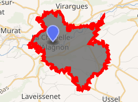
La Chapelle-d'Alagnon
La Chapelle-d'Alagnon is a commune in the Cantal department in south-central France.
La Chapelle-d'Alagnon | |
|---|---|
The Château of Jarrousset | |
Location of La Chapelle-d'Alagnon 
| |
 La Chapelle-d'Alagnon  La Chapelle-d'Alagnon | |
| Coordinates: 45°06′30″N 2°53′50″E | |
| Country | France |
| Region | Auvergne-Rhône-Alpes |
| Department | Cantal |
| Arrondissement | Saint-Flour |
| Canton | Murat |
| Intercommunality | Pays de Murat |
| Government | |
| • Mayor (2008–2014) | Philippe Coudon |
| Area 1 | 9.2 km2 (3.6 sq mi) |
| Population (2017-01-01)[1] | 249 |
| • Density | 27/km2 (70/sq mi) |
| Time zone | UTC+01:00 (CET) |
| • Summer (DST) | UTC+02:00 (CEST) |
| INSEE/Postal code | 15041 /15300 |
| Elevation | 860–1,124 m (2,822–3,688 ft) (avg. 882 m or 2,894 ft) |
| 1 French Land Register data, which excludes lakes, ponds, glaciers > 1 km2 (0.386 sq mi or 247 acres) and river estuaries. | |
Population
| Year | Pop. | ±% |
|---|---|---|
| 1962 | 256 | — |
| 1968 | 264 | +3.1% |
| 1975 | 239 | −9.5% |
| 1982 | 246 | +2.9% |
| 1990 | 236 | −4.1% |
| 1999 | 250 | +5.9% |
| 2008 | 240 | −4.0% |
gollark: Power over Ethernet, bee.
gollark: ++remind 11d <@!402456897812168705> <@!402456897812168705> <@!402456897812168705> apio-forms
gollark: Really?
gollark: It is kind of a shame that stuff didn't end up developing such that everything was carried over generic data traffic links, and instead we got dedicated cables and protocols and everything for video, general-purpose peripherals, and data networks.
gollark: Interesting idea.
See also
References
- "Populations légales 2017". INSEE. Retrieved 6 January 2020.
| Wikimedia Commons has media related to La Chapelle-d'Alagnon. |
This article is issued from Wikipedia. The text is licensed under Creative Commons - Attribution - Sharealike. Additional terms may apply for the media files.