Grade II* listed buildings in Torridge
There are over 20,000 Grade II* listed buildings in England. This page is a list of these buildings in the district of Torridge in Devon.
Torridge
| Name | Location | Type | Completed [note 1] | Date designated | Grid ref.[note 2] Geo-coordinates |
Entry number [note 3] | Image |
|---|---|---|---|---|---|---|---|
| Church of St James | Abbots Bickington, Torridge | Parish Church | c. 1300 | 14 February 1958 | SS3847613261 50°53′46″N 4°17′54″W |
1105113 | 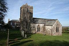 Church of St James |
| Church of St Helen | Abbotsham | Anglican Church | Late 19th century | 20 February 1958 | SS4245926415 51°00′56″N 4°14′50″W |
1104408 | .jpg) Church of St Helen |
| Church of All Saints | Alverdiscott | Anglican Church | 1579 | 4 October 1960 | SS5195025257 51°00′27″N 4°06′42″W |
1170720 | .jpg) Church of All Saints |
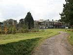
| Portledge Manor | Alwington | Country house | Early 19th century | 22 January 1952 | SS3942224720 50°59′58″N 4°17′23″W |
1170778 | |
| Church of St James | Ashreigney | Parish Church | Pre-Perpendicular | 4 October 1960 | SS6286313626 50°54′21″N 3°57′07″W |
1104609 |  Church of St James |
| Bell Tower Cottage | Ashwater | House | 18th century | 21 January 1986 | SX3864695234 50°44′03″N 4°17′16″W |
1104661 |  |
| Old Parsonage | Beaford | House | C20 | 16 February 1989 | SS5508115641 50°55′19″N 4°03′48″W |
1309063 | |
| Woolleigh Barton and adjoining Former Chapel | Woolleigh, Beaford | Farmhouse | 15th century or Earlier | 16 January 1952 | SS5317916872 50°55′57″N 4°05′27″W |
1105074 | |
| Church of St Mary | Bideford | Parish Church | Probably 15th century | 8 November 1949 | SS4538626423 51°00′59″N 4°12′20″W |
1200893 | 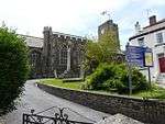 Church of St Mary |
| Lavington United Reformed Church | Bideford | Congregational Chapel | 1856-9 | 19 April 1993 | SS4535126826 51°01′12″N 4°12′23″W |
1355163 |  Lavington United Reformed Church |
| Masonic Hall, Caretaker's House at Rear and Garden Walls at Left and Rear | Bideford | House | 1692 | 8 November 1949 | SS4536526825 51°01′12″N 4°12′22″W |
1025135 |  Masonic Hall, Caretaker's House at Rear and Garden Walls at Left and Rear |
| Northdown Hall (part of Stella Maris School) | Bideford | House | Early 19th century | 24 July 1974 | SS4511826980 51°01′17″N 4°12′35″W |
1200936 | |
| 4 and 4a Bridgeland Street | Bideford, Torridge | House | 1692 | 8 November 1949 | SS4545426832 51°01′12″N 4°12′17″W |
1200874 | |
| 27 Bridgeland Street | Bideford | House | Probably early 1690s | 8 November 1949 | SS4540526794 51°01′11″N 4°12′20″W |
1025052 | |
| Nos 28 and 28a, Bridgeland St, including Pump and Milestone in Courtyard | Bideford | Apartment | 1949 | 8 November 1949 | SS4541826785 51°01′11″N 4°12′19″W |
1200879 | |
| 31 Bridgeland Street | Bideford | Apartment | 1992 | 6 May 1992 | SS4546026796 51°01′11″N 4°12′17″W |
1025001 | |
| Old Ford | Bideford | Farmhouse | 19th century | 8 November 1949 | SS4531025908 51°00′42″N 4°12′23″W |
1200933 | |
| 74 and 74a High Street | Bideford | Apartment | 1999 | 8 November 1949 | SS4533726601 51°01′05″N 4°12′23″W |
1208979 | |
| Church of St Mary | Black Torrington | Parish Church | 15th century | 14 February 1958 | SS4649305709 50°49′50″N 4°10′52″W |
1105121 | 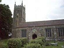 Church of St Mary |
| Higher Braundsworthy Farmhouse | Black Torrington | Farmhouse | c. 1500 | 26 January 1989 | SS4387805856 50°49′52″N 4°13′06″W |
1326550 | |
| Hole Farmhouse | Black Torrington | Farmhouse | 16th century | 26 January 1989 | SS4701903822 50°48′49″N 4°10′22″W |
1105119 | |
| Church of All Saints | Bradford | Parish Church | Norman origins | 26 January 1989 | SS4212707220 50°50′34″N 4°14′37″W |
1105088 | 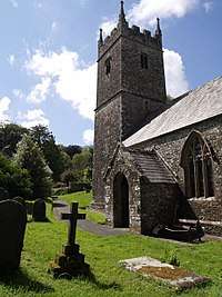 Church of All Saints |
| Highstead Farmhouse | Bradford | Farmhouse | probably by the early 17th century | 14 February 1958 | SS4197605263 50°49′31″N 4°14′42″W |
1326575 | |
| Church of St John the Baptist | Bradworthy | Anglican Church | 18th century | 14 February 1958 | SS3246813981 50°54′03″N 4°23′02″W |
1163892 | 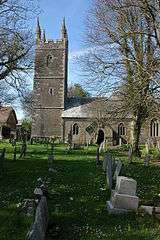 Church of St John the Baptist |
| Outbuilding, formerly Chapel, 25 Metres North East of Lower Alsworthy Farmhouse | Alfardisworthy, Bradworthy | Chapel | 15th century | 14 February 1958 | SS2941411765 50°52′48″N 4°25′35″W |
1104971 | |
| Tackbeare Farmhouse | Bridgerule | Manor House | Late 16th century | 14 February 1958 | SS2574001887 50°47′25″N 4°28′25″W |
1104975 | |
| Palmer Headstone about 37m North of the West Tower of the Church of St Nicholas | Broadwoodwidger | Gravestone | Late 18th century | 21 January 1986 | SX4111489207 50°40′51″N 4°15′01″W |
1165023 | |
| Upcott | Broadwoodwidger | Farmhouse | late C15/early 16th century or earlier | 23 August 1957 | SX3966790114 50°41′19″N 4°16′16″W |
1164919 | |
| Church of St Mary and St Benedict | Buckland Brewer | Church | 18th century | 20 February 1958 | SS4189020915 50°57′57″N 4°15′11″W |
1105169 | 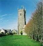 Church of St Mary and St Benedict |
| Buckland House | Buckland Filleigh | Country House | core of earlier house | 4 October 1960 | SS4646809167 50°51′42″N 4°10′59″W |
1104551 | |
| Church of St Mary | Buckland Filleigh | Parish Church | Norman | 4 October 1960 | SS4655309152 50°51′41″N 4°10′54″W |
1104552 | .jpg) Church of St Mary |
| Church of St Michael | Bulkworthy | Church | 1874 | 18 December 1989 | SS3947414186 50°54′17″N 4°17′04″W |
1104977 | 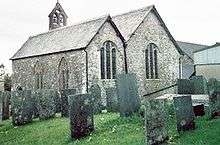 Church of St Michael |
| No 16 including Forecourt Retaining Walls, Railings and Gates | Clovelly | House | Early 18th century | 20 February 1958 | SS3171824806 50°59′53″N 4°23′58″W |
1104517 | |
| Nos 45/46 and 47 | Clovelly | House | 20 February 1958 | SS3183024852 50°59′54″N 4°23′53″W |
1104522 | | |
| No 53 (Crazy Kates) and No 54 | Clovelly | Fishermans House | Probably 18th century | 20 February 1958 | SS3184024867 50°59′55″N 4°23′52″W |
1333120 | |
| 59, 60 and 61 | Clovelly | House | Late 17th century or Early 18th century | 20 February 1958 | SS3186424822 50°59′53″N 4°23′51″W |
1333138 | |
| Church of St John the Baptist and the Seven Maccabees | Cookbury | Parish Church | Norman origins | 14 February 1958 | SS4070806044 50°49′55″N 4°15′48″W |
1162728 | 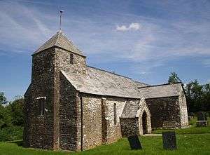 Church of St John the Baptist and the Seven Maccabees |
| Chapple Cottage | Dolton | House | circa Mid 16th century | 10 March 1988 | SS5576510663 50°52′39″N 4°03′05″W |
1333048 | |
| Church of St Edmund | Dolton | Cross | Saxon | 4 October 1960 | SS5700312012 50°53′23″N 4°02′04″W |
1104629 | 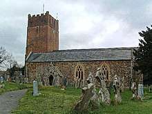 Church of St Edmund |
| Stafford Barton | Dolton | House | 1956 | 20 December 1956 | SS5843011463 50°53′07″N 4°00′50″W |
1104627 | |
| Church of St Michael and All Angels | Great Torrington | Parish Church | Possibly 13th century | 19 March 1951 | SS4950519196 50°57′09″N 4°08′38″W |
1104787 |  Church of St Michael and All Angels |
| Market House | Great Torrington | House | 1842 | 19 March 1951 | SS4957019087 50°57′06″N 4°08′35″W |
1104742 | 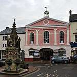 Market House |
| Palmer House including Garden Wall | Great Torrington | House | 1752 | 19 March 1951 | SS4943719233 50°57′10″N 4°08′42″W |
1104777 |  Palmer House including Garden Wall |
| 28 South Street | Great Torrington | House | 1701 | 3 April 1973 | SS4950519065 50°57′05″N 4°08′38″W |
1104743 | |
| Church of St Peter and St James | Halwill | Parish Church | 14th century or earlier | 14 February 1958 | SX4272499431 50°46′23″N 4°13′55″W |
1104639 | 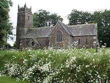 Church of St Peter and St James |
| Winsford Hospital | Halwill Junction, Halwill | Conservatory | C20 | 15 April 1978 | SX4454599993 50°46′43″N 4°12′23″W |
1105657 | |
| Church House | Stoke, Hartland | House | Probably late 15th century | 20 February 1958 | SS2358124670 50°59′40″N 4°30′55″W |
1146627 | |
| Courtyard Wall immediately to West of Blegberry Farmhouse and extending Approximately 50 Metres to the South | Hartland | Farmhouse | 1606 | 20 February 1958 | SS2319226135 51°00′26″N 4°31′18″W |
1165704 | |
| Galsham Farmhouse | Hartland | Farmhouse | 1682 | 19 June 1989 | SS2450322697 50°58′37″N 4°30′05″W |
1104474 | |
| Higher Brownsham Farmhouse and Barn adjoining to North-west | Brownsham, Hartland | Farmhouse | Early 17th century | 20 February 1958 | SS2853625946 51°00′26″N 4°26′43″W |
1333156 |  Higher Brownsham Farmhouse and Barn adjoining to North-west |
| St Leonards Cottage (north) | Hartland, Torridge | House | 18th century or Early 19th century | 19 June 1989 | SS2488923884 50°59′16″N 4°29′47″W |
1104480 | |
| St Leonards Cottage (south) | Hartland, Torridge | House | c. 1500 | 19 June 1989 | SS2489823869 50°59′15″N 4°29′46″W |
1166060 | |
| Lee Barton and Adjoining Front Garden Walls | Lee Barton, High Bickington, Torridge | Farmhouse | 15th century or 16th century | 4 October 1960 | SS5761820912 50°58′12″N 4°01′45″W |
1326595 | |
| Church of St Peter and St Paul | Holsworthy, Torridge | Anglican Church | 1808 | 1 January 1951 | SS3437703907 50°48′40″N 4°21′08″W |
1104945 | 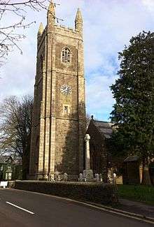 Church of St Peter and St Paul |
| Derriton Viaduct | Holsworthy, Torridge | Railway Viaduct | 1898 | 18 December 1989 | SS3387303531 50°48′27″N 4°21′33″W |
1317898 | .jpg) Derriton Viaduct |
| Church of St James the Less | Huish, Huish, Torridge | Parish Church | Late 15th century or Early 16th century | 4 October 1960 | SS5337311081 50°52′50″N 4°05′08″W |
1309259 | 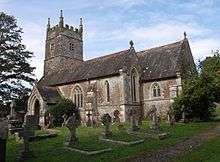 Church of St James the Less |
| Church of St Mary Magdalene | Huntshaw, Torridge | Anglican Church | Early 14th century | 4 October 1960 | SS5067122892 50°59′10″N 4°07′44″W |
1326528 | .jpg) Church of St Mary Magdalene |
| Church of Holy Trinity | Landcross, Torridge | Anglican Church | Early 19th century | 20 February 1958 | SS4627523847 50°59′36″N 4°11′31″W |
1105150 | _(geograph_4583902).jpg) Church of Holy Trinity |
| Church (consecration Unknown) | Langtree, Torridge | Parish Church | 15th century to the early 16th century | 4 October 1960 | SS4510915575 50°55′08″N 4°12′18″W |
1104560 | 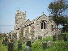 Church (consecration Unknown) |
| Chapel of St Mary Magdalene | Taddiport, Little Torrington, Torridge | Chapel | 13th century | 4 October 1960 | SS4877618664 50°56′51″N 4°09′15″W |
1147254 |  Chapel of St Mary Magdalene |
| Church of St Giles | Little Torrington, Little Torrington, Torridge | Parish Church | 15th century | 16 February 1989 | SS4910116851 50°55′53″N 4°08′55″W |
1105026 | 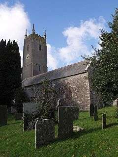 Church of St Giles |
| Cross House | Little Torrington, Torridge | Country House | 1680-85 | 4 October 1960 | SS4873617532 50°56′14″N 4°09′15″W |
1105022 | 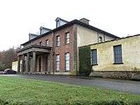 Cross House |
| South Hole Farmhouse | Little Torrington, Torridge | Farmhouse | Early 17th century | 16 February 1989 | SS5047215825 50°55′21″N 4°07′44″W |
1105024 | |
| Woodland Farmhouse | Little Torrington, Torridge | Farmhouse | Second half of the 15th century | 4 October 1960 | SS5039716854 50°55′54″N 4°07′49″W |
1326584 | |
| Church of All Saints | Merton, Merton, Torridge | Parish Church | 14th century | 4 October 1960 | SS5257412031 50°53′20″N 4°05′51″W |
1326588 | .jpg) Church of All Saints |
| Downes House | Merton, Merton, Torridge | Farmhouse | Early-Mid 17th century | 4 October 1960 | SS5295612312 50°53′29″N 4°05′32″W |
1147488 | |
| Garden Wall Extending to South of Great Potheridge | Great Potheridge, Merton, Torridge | Garden Wall | 1660-70 | 16 February 1989 | SS5139114622 50°54′43″N 4°06′55″W |
1105033 | |
| Church of Holy Trinity | Milton Damerel, Milton Damerel, Torridge | Sundial | 1808 | 14 February 1958 | SS3845010717 50°52′24″N 4°17′51″W |
1162778 | .jpg) Church of Holy Trinity |
| Church of St Petrock | Newton St Petrock, Newton St. Petrock, Torridge | Sundial | dated 1723 | 26 January 1989 | SS4113012236 50°53′16″N 4°15′36″W |
1105096 | .jpg) Church of St Petrock |
| Diddywell | Northam, Northam, Torridge | Farmhouse | Formerly | 15 June 1951 | SS4544329832 51°02′49″N 4°12′23″W |
1306534 | |
| Docton House | Appledore, Northam, Torridge | House | circa late 16th century or early 17th century | 15 June 1951 | SS4643730350 51°03′07″N 4°11′32″W |
1333011 | |
| Orchard Hill House | Northam, Northam, Torridge | House | late 18th century or early 19th century | 19 February 1973 | SS4532527644 51°01′38″N 4°12′25″W |
1267190 | |
| Porthill | Northam, Northam, Torridge | House | 1760 | 19 February 1973 | SS4480428400 51°02′02″N 4°12′53″W |
1306519 | |
| Richmond Dock | Appledore, Northam, Torridge | Dry Dock | 1856 | 12 February 1987 | SS4647130324 51°03′06″N 4°11′31″W |
1140140 | .jpg) Richmond Dock |
| Church of St Pancras | Village Centre, Pancrasweek, Torridge | Anglican Church | 1894-8 | 14 February 1958 | SS2968305821 50°49′37″N 4°25′11″W |
1164477 | 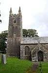 Church of St Pancras |
| Church of St James | Parkham, Torridge | Sundial | 1731 | 20 February 1958 | SS3890221509 50°58′13″N 4°17′45″W |
1326557 | .jpg) Church of St James |
| Church of St Petrock | Petrockstowe, Petrockstow, Torridge | Parish Church | Norman | 4 October 1960 | SS5131909162 50°51′46″N 4°06′51″W |
1333084 | .jpg) Church of St Petrock |
| Little Marland | Petrockstow, Torridge | Farmhouse | Circa 1500-1525 | 4 October 1960 | SS4992311958 50°53′15″N 4°08′06″W |
1104530 | |
| Church of St Swithin | Village Centre, Pyworthy, Torridge | Anglican Church | 1885 | 14 February 1958 | SS3129202881 50°48′03″N 4°23′44″W |
1164560 | .jpg) Church of St Swithin |
| Church of Saint Peter | Roborough, Roborough, Torridge | Parish Church | C13/C14 | 4 October 1960 | SS5769217120 50°56′09″N 4°01′36″W |
1326612 | .jpg) Church of Saint Peter |
| Coombe Barton and Adjoining Front Garden Walls | Coombe Barton, Roborough, Torridge | Farmhouse | Late C16/Early 17th century | 16 January 1952 | SS5673417983 50°56′36″N 4°02′26″W |
1105040 | |
| Ebberly House | Ebberly, Roborough, Torridge | House | Before c1816 | 16 January 1952 | SS5647318549 50°56′54″N 4°02′40″W |
1105001 | 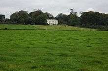 Ebberly House |
| Great Barlington Farmhouse and Adjoining Front Garden Walls | Great Barlington, Roborough, Torridge | Farmhouse | Early 18th century | 16 February 1989 | SS5667316459 50°55′47″N 4°02′27″W |
1326611 | |
| Church of St Michael | Shebbear, Shebbear, Torridge | Parish Church | Norman | 4 October 1960 | SS4384509228 50°51′41″N 4°13′13″W |
1309558 | .jpg) Church of St Michael |
| Church of St Lawrence | Sheepwash, Sheepwash, Torridge | Parish Church | earlier building | 4 October 1960 | SS4869606328 50°50′12″N 4°09′00″W |
1104503 | .jpg) Church of St Lawrence |
| The Library | Stevenstone Park, St. Giles in the Wood, Torridge | Library | Late C17-Early 18th century | 4 October 1960 | SS5268419337 50°57′16″N 4°05′56″W |
1104996 | 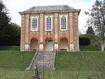 The Library |
| The Orangery | Stevenstone Park, St. Giles in the Wood, Torridge | Orangery | c. 1720 | 4 October 1960 | SS5269619380 50°57′18″N 4°05′55″W |
1168092 | 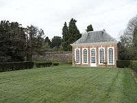 The Orangery |
| Church of St Giles | St Giles on the Heath, St. Giles on the Heath, Torridge | Parish Church | 13th century | 23 August 1957 | SX3536790756 50°41′35″N 4°19′56″W |
1333042 | .jpg) Church of St Giles |
| Nether Bridge | St. Giles on the Heath, Torridge | Milestone | Medieval | 9 January 1986 | SX3485686736 50°39′25″N 4°20′16″W |
1104690 | |
| Church of St Andrew | Sutcombe, Sutcombe, Torridge | Obelisk | 1742 | 14 February 1958 | SS3469711666 50°52′51″N 4°21′04″W |
1326580 | 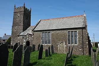 Church of St Andrew |
| Manor Cottage Tetcott Barton Tetcott Manor | Tetcott, Tetcott, Torridge | Cross Passage House | 16th century | 4 December 1951 | SX3315896575 50°44′41″N 4°21′58″W |
1262341 | |
| Church of St Peter | Thornbury, Thornbury, Torridge | Parish Church | Norman origins | 14 February 1958 | SS4006208455 50°51′12″N 4°16′25″W |
1162910 | .jpg) Church of St Peter |
| Church of St Nectan | Welcombe, Welcombe, Torridge | Anglican Church | 1508 | 20 February 1958 | SS2281018434 50°56′17″N 4°31′24″W |
1333126 | |
| Cory Manor | Village Centre, West Putford, Torridge | Manor House | Late C16-Early 17th century | 14 February 1958 | SS3598715752 50°55′04″N 4°20′05″W |
1104954 | |
| Lower Bransgrove | Winkleigh, Torridge | Farmhouse | Probably 14th century | 18 June 1991 | SS6580010770 50°52′51″N 3°54′32″W |
1104575 | |
| Parish Church of St Andrew | Yarnscombe, Yarnscombe, Torridge | Parish Church | 13th century | 4 October 1960 | SS5616323600 50°59′38″N 4°03′04″W |
1104961 | .jpg) Parish Church of St Andrew |
| Lightkeeper's House Old Lighthouse | Torridge | Lighthouse | 1787 | 7 October 1991 | SS1320444290 51°10′02″N 4°40′23″W |
1326646 | 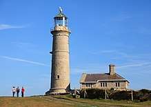 Lightkeeper's House Old Lighthouse |
| Marisco Castle, Keep and Bailey Walls | Torridge | Bailey | 1243 | 7 October 1991 | SS1414643772 51°09′47″N 4°39′34″W |
1104957 | 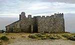 Marisco Castle, Keep and Bailey Walls |

.jpg)
Notes
- The date given is the date used by Historic England as significant for the initial building or that of an important part in the structure's description.
- Sometimes known as OSGB36, the grid reference is based on the British national grid reference system used by the Ordnance Survey.
- The "List Entry Number" is a unique number assigned to each listed building and scheduled monument by Historic England.
gollark: Please add AutoBotRobot by the way?
gollark: Good news, I infiltrated the yBot discord server.
gollark: I know a geometry dash player, clearly I should tell them?!
gollark: Via node.js.
gollark: I downloaded all YouTube videos on yBot directly into my brain.
External links
![]()
This article is issued from Wikipedia. The text is licensed under Creative Commons - Attribution - Sharealike. Additional terms may apply for the media files.