Grade II* listed buildings in Tonbridge and Malling
There are over 20,000 Grade II* listed buildings in England. This page is a list of these buildings in the district of Tonbridge and Malling in Kent.
Tonbridge and Malling
| Name | Location | Type | Completed [note 1] | Date designated | Grid ref.[note 2] Geo-coordinates |
Entry number [note 3] | Image |
|---|---|---|---|---|---|---|---|
| Ford Place and Wall to North | Addington | Farmhouse | 18th century | 1 August 1952 | TQ6365058575 51°18′10″N 0°20′46″E |
1236317 |  |
| Court Farmhouse | Aylesford | Farmhouse | 1952 | 1 August 1952 | TQ7279159047 51°18′16″N 0°28′39″E |
1070571 | |
| The Chequers Public House | Aylesford | Jettied House | Early 16th century | 1 August 1952 | TQ7291258977 51°18′13″N 0°28′45″E |
1111803 | 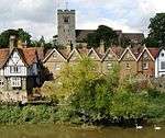 The Chequers Public House |
| The George House (previously George Inn) | Aylesford | Continuous Jetty House | Mid 16th century | 1 August 1952 | TQ7297358967 51°18′13″N 0°28′48″E |
1070545 | 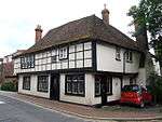 The George House (previously George Inn) |
| Trinity Court | Aylesford | Row | 1607 | 1 August 1952 | TQ7312159048 51°18′15″N 0°28′56″E |
1298997 | 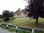 Trinity Court |
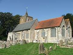
| Church of St Peter Ad Vincula | Ditton | Church | 12th century | 25 August 1959 | TQ7098658048 51°17′45″N 0°27′04″E |
1099197 | 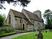 Church of St Peter Ad Vincula |
| Stream Cottages | Ditton | House | c1480-1500 | 25 February 1987 | TQ7100158162 51°17′49″N 0°27′05″E |
1070527 | |
| Derbies | East Malling and Larkfield | House | C15/C16 | 12 November 1986 | TQ6943256530 51°16′58″N 0°25′41″E |
1363131 | |
| Paris Farmhouse | East Malling and Larkfield | House | 16th century | 1 August 1952 | TQ7046256689 51°17′02″N 0°26′35″E |
1363129 | |
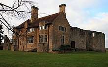
| The Barracks | East Malling and Larkfield | Farmhouse | circa 1380-1400 | 1 August 1952 | TQ6939556552 51°16′59″N 0°25′39″E |
1070512 | 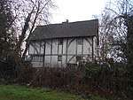 The Barracks |
| The Wealden Hall Restaurant | East Malling and Larkfield | Farmhouse | Late 14th century | 25 February 1987 | TQ7035158303 51°17′54″N 0°26′32″E |
1070501 | 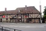 The Wealden Hall Restaurant |
| 4 and 6 Church Walk | East Malling and Larkfield | Wealden House | Early 15th century | 1 August 1952 | TQ7019857089 51°17′15″N 0°26′22″E |
1349080 | 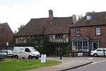 4 and 6 Church Walk |
| Church of St Michael | Old Peckham, East Peckham | Parish Church | c. 1300 | 25 August 1959 | TQ6616152169 51°14′40″N 0°22′45″E |
1363012 | |
| Dower House | East Peckham | House | Possibly earlier this century | 1 August 1952 | TQ6643251704 51°14′25″N 0°22′58″E |
1299613 | |
| Forge Gate Farmhouse | East Peckham | House | Later wing | 19 April 1985 | TQ6555552494 51°14′51″N 0°22′15″E |
1185270 | |
| Oast Houses and Granaries at Whitbreads Hop Farm | East Peckham | Oasthouse | Early C20 | 25 August 1959 | TQ6740047504 51°12′08″N 0°23′41″E |
1070722 | |
| Roydon Hall | East Peckham | Country House | 1535(inscription) | 1 August 1952 | TQ6658151711 51°14′25″N 0°23′06″E |
1363037 | 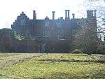 Roydon Hall |
| Church of St Mary | Hadlow | Church | c. 1066 | 20 October 1954 | TQ6345449714 51°13′24″N 0°20′22″E |
1070466 | 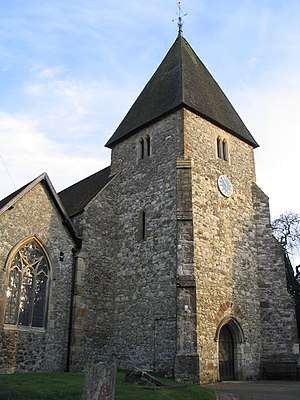 Church of St Mary |
| Gateway to Hadlow Castle | Hadlow | Gate | c. 1820 | 20 October 1954 | TQ6335149741 51°13′25″N 0°20′16″E |
1363139 | 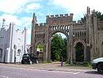 Gateway to Hadlow Castle |
| Hadlow Place | Golden Green, Hadlow | Kitchen | Early/mid 16th century | 20 October 1954 | TQ6293748218 51°12′36″N 0°19′53″E |
1070457 | |
| North Lodge | Hadlow | Gatehouse | c. 1820 | 20 October 1954 | TQ6336049750 51°13′25″N 0°20′17″E |
1237277 | North Lodge |
| Poplar Court | Golden Green, Hadlow | House | Early/mid 16th century | 20 October 1954 | TQ6457348176 51°12′33″N 0°21′17″E |
1070420 | 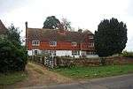 Poplar Court |
| Ranges round the Stable Yard west of Hadlow Tower, Hadlow Castle | Hadlow | House | 1990 | 19 February 1990 | TQ6343649674 51°13′22″N 0°20′21″E |
1237300 | |
| South Lodge | Hadlow | Gatehouse | c. 1820 | 20 October 1954 | TQ6334049733 51°13′24″N 0°20′16″E |
1237249 | |
| Spring Place | Hadlow | House | Mid/late 15th century | 20 October 1954 | TQ6279251063 51°14′08″N 0°19′50″E |
1236819 | 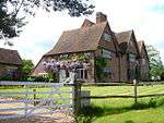 Spring Place |
| The Old Farmhouse | Golden Green, Hadlow | Farmhouse | 17th century | 20 October 1954 | TQ6342848035 51°12′29″N 0°20′18″E |
1237176 | |
| Nizels Cottage | Hildenborough | House | Mid 17th century | 20 October 1954 | TQ5461950451 51°13′56″N 0°12′48″E |
1248222 | |
| Old House | Hildenborough | House | Late Medieval | 20 October 1954 | TQ5527248813 51°13′03″N 0°13′19″E |
1363156 | |
| Ightham Court | Ightham | House | Mid 16th century | 1 August 1952 | TQ5950657559 51°17′41″N 0°17′11″E |
1071968 | |
| Ightham Place | Ightham | House | Late 18th century | 3 May 1984 | TQ5957756747 51°17′15″N 0°17′13″E |
1071981 | |
| Mote Farm Cottages & Old Laundry Cottage | Ightham | Row | 16th century | 1 August 1952 | TQ5838753459 51°15′30″N 0°16′07″E |
1362411 | |
| Old Forge House | Ightham | Continuous Jetty House | 16th century | 1 August 1952 | TQ5955256739 51°17′15″N 0°17′12″E |
1204195 | 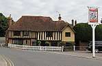 Old Forge House |
| Church of St Peter and St Paul | Leybourne | Church | 12th century | 25 August 1959 | TQ6894958929 51°18′16″N 0°25′20″E |
1100628 | 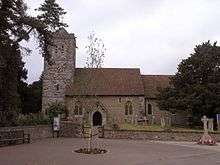 Church of St Peter and St Paul |
| Leybourne Castle | Leybourne | Castle | Early 14th century | 25 August 1959 | TQ6886658910 51°18′15″N 0°25′16″E |
1363097 | |
| Church Farmhouse | Offham | Farmhouse | c. 1620 | 1 August 1952 | TQ6598158048 51°17′51″N 0°22′46″E |
1236003 | |
| Quintain House | Offham | House | c. 1700 | 1 August 1952 | TQ6571357317 51°17′27″N 0°22′31″E |
1264803 |  Quintain House |
| The Manor House | Offham | House | 17th century | 1 August 1952 | TQ6583257296 51°17′26″N 0°22′37″E |
1264775 | |
| Great Comp | Platt | House | Possibly earlier house | 1 August 1952 | TQ6319156760 51°17′12″N 0°20′20″E |
1071988 | |
| Nepicar House | Platt | House | Earlier | 1 August 1952 | TQ6290658345 51°18′03″N 0°20′08″E |
1071991 |  Nepicar House |
| Clakkers Hall | Plaxtol | Farmhouse | Late C15-early 16th century | 13 July 1973 | TQ6125155496 51°16′33″N 0°18′38″E |
1281020 | 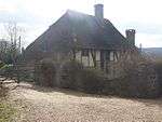 Clakkers Hall |
| Plaxtol Church | Plaxtol | Church | 1649 | 3 May 1984 | TQ6019553640 51°15′34″N 0°17′40″E |
1072684 | 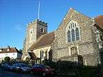 Plaxtol Church |
| Rats Castle | Plaxtol | Farmhouse | Possibly 14th century | 1 August 1952 | TQ6255553083 51°15′13″N 0°19′41″E |
1362027 | |
| Spoute House | Plaxtol | House | c. 1600 | 3 May 1984 | TQ6115053650 51°15′33″N 0°18′29″E |
1204588 | |
| The Grange | Plaxtol | House | Early 17th century | 1 August 1952 | TQ6043253892 51°15′42″N 0°17′53″E |
1072687 | |
| Church of St Martin | Ryarsh | Church | 12th century | 25 August 1959 | TQ6723459136 51°18′24″N 0°23′52″E |
1070477 | 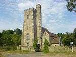 Church of St Martin |
| Church of Our Lady of the Meadow | Dode, Snodland | Church | 12th century | 25 August 1959 | TQ6685563725 51°20′53″N 0°23′40″E |
1101756 | 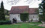 Church of Our Lady of the Meadow |
| Church of St Benedict | Paddlesworth, Snodland | Church | Early 12th century | 25 August 1959 | TQ6847462116 51°19′59″N 0°25′01″E |
1363120 | 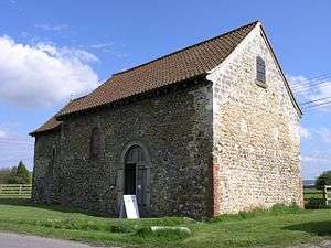 Church of St Benedict |
| Mulberry Cottages | Snodland | House | 1932 | 1 August 1952 | TQ7048461815 51°19′48″N 0°26′45″E |
1070485 | 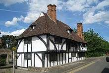 Mulberry Cottages |
| Woodlands Farmhouse | Snodland | Farmhouse | c. 1880 | 16 January 1981 | TQ6980761991 51°19′54″N 0°26′10″E |
1101517 | |
| Church of St Mary | Stansted | Church | c. 1400 | 25 August 1959 | TQ6073662124 51°20′08″N 0°18′22″E |
1236153 | 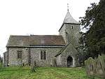 Church of St Mary |
| Fairseat Manor and Garden Wall to North | Stansted | House | 17th century | 1 August 1952 | TQ6220261440 51°19′44″N 0°19′36″E |
1236169 | |
| South Ash Manor | Stansted | Jettied House | 16th century | 1 August 1952 | TQ5958863161 51°20′42″N 0°17′24″E |
1236122 | |
| Church of Saint John the Baptist | Wateringbury | Parish Church | 13th century | 25 August 1959 | TQ6853353674 51°15′26″N 0°24′50″E |
1070664 |  Church of Saint John the Baptist |
| Pelican Farmhouse | Wateringbury | House | Later much altered | 1 August 1952 | TQ6924953506 51°15′20″N 0°25′27″E |
1320018 | 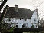 Pelican Farmhouse |
| The Tomb of Sir Oliver Style in the Church of Saint John the Baptist Churchyard | Wateringbury | Table Tomb | c. 1702 | 19 April 1985 | TQ6853953645 51°15′25″N 0°24′50″E |
1320027 | |
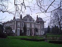
| Wateringbury Place | Wateringbury | House | c. 1707 | 1 August 1952 | TQ6843053710 51°15′28″N 0°24′45″E |
1116485 | 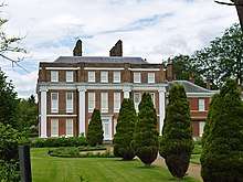 Wateringbury Place |
| Brome House | West Malling | Bothy | may have been | 1 August 1952 | TQ6793357516 51°17′31″N 0°24′26″E |
1209103 | |
| Church of the Resurrection of Our Lord Jesus Christ and of the Blessed Virgin Mary, West Malling Abbey | West Malling | Abbey | 1964-1966 | 18 February 1999 | TQ6829757704 51°17′37″N 0°24′45″E |
1245579 | |
| Douce's Manor | West Malling | House | c. 1776 | 1 August 1952 | TQ6774357320 51°17′25″N 0°24′15″E |
1209122 | 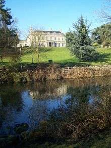 Douce's Manor |
| Abbey Tithe Barn then Ewell Monastery Chapel | West Malling | Tithe Barn/Chapel | 15th century | 30 November 1993 | TQ6813257518 51°17′31″N 0°24′36″E |
1292794 | .JPG) Abbey Tithe Barn then Ewell Monastery Chapel |
| Malling Place | West Malling | House | dates from 1560 | 1 August 1952 | TQ6761957147 51°17′20″N 0°24′09″E |
1219060 | 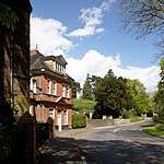 Malling Place |
| Parish Church of St Mary the Virgin | West Malling | Parish Church | Norman | 25 August 1959 | TQ6789957538 51°17′32″N 0°24′24″E |
1292816 | 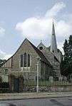 Parish Church of St Mary the Virgin |
| Prior's Cottage the Priors | West Malling | House | 16th century | 30 November 1993 | TQ6803257904 51°17′44″N 0°24′31″E |
1209113 | |
| The Assembly Rooms | West Malling | Assembly Rooms | earlier foundations | 1 August 1952 | TQ6803957858 51°17′42″N 0°24′32″E |
1218061 | |
| The Bakery Restaurant | West Malling | Apartment | Late 16th century | 1 August 1952 | TQ6805857836 51°17′41″N 0°24′33″E |
1218117 | |
| Went House | West Malling | House | c. 1710 | 1 August 1952 | TQ6833857741 51°17′38″N 0°24′47″E |
1219391 | |
| the Lodge | West Malling | House | Early 19th century | 1 August 1952 | TQ6747056774 51°17′08″N 0°24′00″E |
1291654 | |
| Oxon Hoath | West Peckham | House | Remains of late 16th century | 1 August 1952 | TQ6304852140 51°14′42″N 0°20′05″E |
1363044 | |
| The Old Palace | Wrotham | House | Pre 1340 | 1 August 1952 | TQ6128359159 51°18′31″N 0°18′45″E |
1236308 | |
| West House | Wrotham | House | c. 1760 | 1 August 1952 | TQ6103359117 51°18′30″N 0°18′32″E |
1264616 | |
| Wrotham Place | Wrotham | House | c. 1590 | 1 August 1952 | TQ6116659083 51°18′29″N 0°18′39″E |
1264591 | |
| Church of St Peter and St Paul | Tonbridge and Malling | Church | C12-C15 | 8 May 1950 | TQ5917446743 51°11′52″N 0°16′36″E |
1120884 | 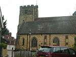 Church of St Peter and St Paul |
| The Port Reeve's House | Tonbridge and Malling | House | Restored after war damage | 8 May 1950 | TQ5923746628 51°11′48″N 0°16′40″E |
1069966 | 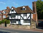 The Port Reeve's House |
| Ye Olde Chequers Inn | Tonbridge and Malling | Inn | 15th century | 8 May 1950 | TQ5905946583 51°11′47″N 0°16′30″E |
1069979 | 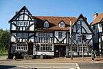 Ye Olde Chequers Inn |
| 124 High Street | Tonbridge and Malling | Jettied House | 15th century | 8 May 1950 | TQ5905446596 51°11′47″N 0°16′30″E |
1363400 | 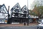 124 High Street |
Notes
- The date given is the date used by Historic England as significant for the initial building or that of an important part in the structure's description.
- Sometimes known as OSGB36, the grid reference is based on the British national grid reference system used by the Ordnance Survey.
- The "List Entry Number" is a unique number assigned to each listed building and scheduled monument by Historic England.
gollark: ++exec```haskellmain = putStr "not my fault if you mix up the arithmetic evaluator and haskelliser```
gollark: It is ++exec.
gollark: You fools.
gollark: Brexit,
gollark: \this is evil.
External links
![]()
This article is issued from Wikipedia. The text is licensed under Creative Commons - Attribution - Sharealike. Additional terms may apply for the media files.