Grade II* listed buildings in Peterborough (unitary)
There are over 20,000 Grade II* listed buildings in England. This page is a list of these buildings in the district of Peterborough in Cambridgeshire.
List
| Name | Location | Type | Completed [note 1] | Date designated | Grid ref.[note 2] Geo-coordinates |
Entry number [note 3] | Image |
|---|---|---|---|---|---|---|---|
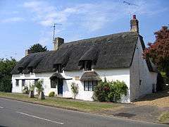
| 7 Station Road | Barnack, City of Peterborough | House | Late 16th century or early 17th century | 19 March 1962 | TF0814005294 52°38′05″N 0°24′13″W |
1226449 |  |
| Castor House | Castor, City of Peterborough | Bishops Palace | 18th century | 15 December 1955 | TL1275298208 52°34′12″N 0°20′16″W |
1162854 | |
| Durobrivae and Pump Against South Wall of Kitchen | Castor, City of Peterborough | Kitchen | Early 18th century | 15 December 1955 | TL1223998577 52°34′24″N 0°20′43″W |
1331585 | |
| Gates, Gate Piers and Flanking Garden Boundary Walls to South of Castor House | Castor, City of Peterborough | Gate | Late 17th century | 15 December 1955 | TL1274398185 52°34′11″N 0°20′17″W |
1126842 | |
| Lodge on Peterborough Drive North East of Ferryhill Plantation | Milton Park, Castor, City of Peterborough | Lodge | 1791 | 15 December 1955 | TL1500698782 52°34′29″N 0°18′16″W |
1126840 | |
| Old Laundry to South East of Milton Hall | Milton Park, Castor, City of Peterborough | Flats | c. 1700 | 15 December 1955 | TL1454299814 52°35′03″N 0°18′39″W |
1309470 | |
| Orangery to South East of Kitchen Garden to Milton Hall | Milton Park, Castor, City of Peterborough | Orangery | c. 1791 | 24 February 1982 | TL1465499587 52°34′55″N 0°18′33″W |
1309489 | |
| Range of Stables and Smithy to East of Milton Hall | Milton Park, Castor, City of Peterborough | Stable | 1720 | 15 December 1955 | TL1457199860 52°35′04″N 0°18′37″W |
1309500 | |
| Bridge over the River Welland | Deeping Gate, City of Peterborough | Bridge | 1651 | 6 May 1952 | TF1507109497 52°40′16″N 0°17′59″W |
1360154 | 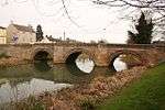 Bridge over the River Welland |
| Manor House | Etton, City of Peterborough | House | 16th century | 15 December 1955 | TF1411106615 52°38′43″N 0°18′54″W |
1126822 | |
| Woodcroft Castle | Etton, City of Peterborough | Castle | Late 13th century | 15 December 1955 | TF1400604502 52°37′35″N 0°19′02″W |
1126782 | |
| Northolme House | Eye, City of Peterborough | House | C16/17 | 15 December 1955 | TF2301404332 52°37′22″N 0°11′03″W |
1365659 | |
| Manor House | Glinton, City of Peterborough | House | Circa 1630-40 | 15 December 1955 | TF1562205944 52°38′20″N 0°17′34″W |
1126792 | 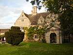 Manor House |
| Stables immediately North North West of Manor House | Glinton, City of Peterborough | Stable | 17th century | 15 December 1955 | TF1561105957 52°38′21″N 0°17′35″W |
1317981 | |
| Clare Cottage | Helpston, City of Peterborough | House | C17/early 18th century | 15 December 1955 | TF1212205333 52°38′03″N 0°20′41″W |
1331603 | |
| Lolham Bridges | Helpston, City of Peterborough | Bridge | 1642 | 15 December 1955 | TF1114807093 52°39′01″N 0°21′31″W |
1365654 | 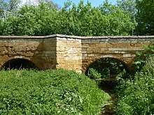 Lolham Bridges |
| Market Cross | Helpston, City of Peterborough | Market Cross | 14th century | 15 December 1955 | TF1216705446 52°38′07″N 0°20′38″W |
1164278 | 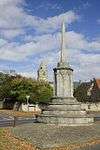 Market Cross |
| Marholm Farmhouse | Marholm, City of Peterborough | Farmhouse | 17th century | 25 February 1950 | TF1498802366 52°36′25″N 0°18′12″W |
1317528 | |
| Ferry Bridge | Orton Waterville, City of Peterborough | Bridge | 1716 | 15 December 1955 | TL1433498459 52°34′19″N 0°18′52″W |
1126812 | |
| Greystones | Peakirk, City of Peterborough | House | 18th century | 15 December 1955 | TF1691606471 52°38′36″N 0°16′25″W |
1221470 | |
| Gatepiers North North East of Thorney Abbey and Abbey House | Thorney, City of Peterborough | Gate Pier | Late 17th century | 24 February 1982 | TF2819204202 52°37′14″N 0°06′28″W |
1331264 | |
| Gatepiers North North West of Thorney Abbey and Abbey House | Thorney, City of Peterborough | Gate Pier | Late 17th century | 24 February 1982 | TF2816604190 52°37′13″N 0°06′29″W |
1127482 | |
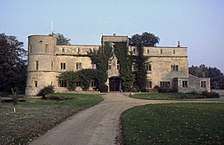
| Manor House | Thornhaugh, City of Peterborough | Manor House | 17th century | 19 March 1962 | TF0672900533 52°35′32″N 0°25′33″W |
1127458 | |
| Sacrewell Mill and Mill House and Stables | Thornhaugh, City of Peterborough | Garage | 1982 | 28 November 1972 | TF0789000063 52°35′16″N 0°24′32″W |
1127493 | 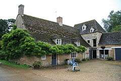 Sacrewell Mill and Mill House and Stables |
| Sibberton Lodge | Thornhaugh, City of Peterborough | House | Medieval | 19 March 1962 | TL0630399914 52°35′12″N 0°25′57″W |
1331255 | |
| Flats Nos 1 to 8 | Ufford, City of Peterborough | Flats | 1982 | 19 March 1962 | TF0930204385 52°37′34″N 0°23′12″W |
1127469 | |
| The Old Rectory | Ufford, City of Peterborough | House | 18th century | 19 March 1962 | TF0938104026 52°37′23″N 0°23′08″W |
1225771 | |
| Garden and Boiler Houses immediately South East of Ufford Hall | Ufford, City of Peterborough | Garden House | 18th century | 19 March 1962 | TF0932904327 52°37′33″N 0°23′11″W |
1357427 | |
| Gatepiers and Wall adjoining South of Stables at Ufford Hall | Ufford, City of Peterborough | Gate Pier | Late 18th century | 24 February 1982 | TF0931504371 52°37′34″N 0°23′11″W |
1066548 | |
| Wall, Gates and Gatepiers to East of Ufford Hall between Stables to North and Garden House to South | Ufford, City of Peterborough | Gate | 18th century | 24 February 1982 | TF0933104353 52°37′33″N 0°23′10″W |
1127470 | |
| Great North Road Bridge carrying North Bound Carriageway over the River Nene | Wansford, City of Peterborough | Road Bridge | 1925-28 | 14 October 1991 | TL0762999368 52°34′53″N 0°24′47″W |
1331276 | 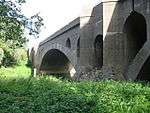 Great North Road Bridge carrying North Bound Carriageway over the River Nene |
| Barn adjoining North of Wothorpe Farmhouse | Wothorpe, City of Peterborough | Barn | 17th century | 19 March 1962 | TF0243405258 52°38′07″N 0°29′16″W |
1127451 | |
| Disused Grandstand to Former Race Course | Wothorpe, City of Peterborough | Grandstand | 1766 | 10 April 1981 | TF0358304146 52°37′31″N 0°28′16″W |
1127413 | |
| Wothorpe Farmhouse | Wothorpe, City of Peterborough | Farmhouse | 17th century | 19 March 1962 | TF0243505236 52°38′07″N 0°29′16″W |
1265974 | |
| Barn to Oxney Farmhouse | Oxney, City of Peterborough | Barn | 17th century | 7 February 1952 | TF2250000973 52°35′34″N 0°11′35″W |
1126924 | |
| Church of All Saints | Peterborough, City of Peterborough | Church | 1901 | 7 May 1973 | TF1943400007 52°35′05″N 0°14′19″W |
1126985 |  Church of All Saints |
| Crescent Waggon Repair Shop | City of Peterborough | Railway Wagon Works | c. 1870 | 12 January 2001 | TL1855798688 52°34′23″N 0°15′07″W |
1334940 |  Crescent Waggon Repair Shop |
| Deanery | Peterborough, City of Peterborough | House | 12th century | 7 February 1952 | TL1946298537 52°34′18″N 0°14′19″W |
1126929 | 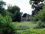 Deanery |
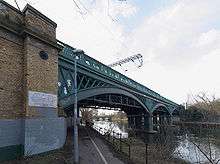
| Great Northern Railway Bridge Number 184 | Peterborough, City of Peterborough | Railway Viaduct | 1850 | 24 October 1988 | TL1903498140 52°34′05″N 0°14′43″W |
1126894 | |
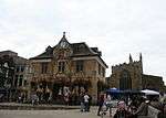
| Old Guild Hall | Peterborough, City of Peterborough | Guildhall | 1671 | 7 February 1952 | TL1915998643 52°34′21″N 0°14′35″W |
1126990 | |
| Oxney Farmhouse | Oxney, City of Peterborough | Farmhouse | 14th century | 7 February 1952 | TF2245900941 52°35′33″N 0°11′37″W |
1162109 | |
| The Rectory | Paston, City of Peterborough | House | circa C13-C14 | 7 February 1952 | TF1832902224 52°36′18″N 0°15′15″W |
1126925 | |
| 10 Queen Street | Peterborough, City of Peterborough | Building | 18th century | 7 February 1952 | TL1904698687 52°34′23″N 0°14′41″W |
1331523 |  10 Queen Street |
| 12 and 12a Minster Precincts | Peterborough, City of Peterborough | House | 13th century core | 7 February 1952 | TL1936898722 52°34′24″N 0°14′24″W |
1310073 | |
Notes
- The date given is the date used by Historic England as significant for the initial building or that of an important part in the structure's description.
- Sometimes known as OSGB36, the grid reference is based on the British national grid reference system used by the Ordnance Survey.
- The "List Entry Number" is a unique number assigned to each listed building and scheduled monument by Historic England.
gollark: Besides, it is probably faster than most storage systems would be in the same situation. Except Artist, which is much better optimized.
gollark: 1. for some reason, it was turned on several times2. there were lots of NBT-having items so display name caching didn't work very well
gollark: It only lags lots in bizarre edge cases.
gollark: The reason is more "I'm quite lazy" and "this way it will be harder to handle the problems which do occur when my data model does not match reality".
gollark: Sure, but in this case the simple solution is probably just to make printed pages not get display names handled individually.
External links
![]()
This article is issued from Wikipedia. The text is licensed under Creative Commons - Attribution - Sharealike. Additional terms may apply for the media files.