Grade II* listed buildings in East Staffordshire
There are over 20,000 Grade II* listed buildings in England. This page is a list of these buildings in the district of East Staffordshire in Staffordshire.
East Staffordshire
| Name | Location | Type | Completed [note 1] | Date designated | Grid ref.[note 2] Geo-coordinates |
Entry number [note 3] | Image |
|---|---|---|---|---|---|---|---|
| Church House | Abbots Bromley, East Staffordshire | House | Mid C20 | 10 January 1953 | SK0794424630 52°49′09″N 1°53′01″W |
1038414 |  |
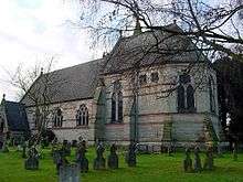
| Church of St Nicholas | Abbots Bromley, East Staffordshire | Parish Church | c. 1300 | 12 January 1966 | SK0793524560 52°49′07″N 1°53′01″W |
1374461 | 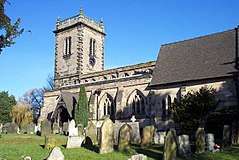 Church of St Nicholas |
| The Butter Cross | Abbots Bromley, East Staffordshire | Village Cross | 17th century | 12 January 1966 | SK0804224576 52°49′07″N 1°52′56″W |
1038424 | 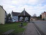 The Butter Cross |
| Barton Hall | Barton-under-Needwood, East Staffordshire | House | Late 18th century | 17 September 1952 | SK1894218847 52°46′01″N 1°43′15″W |
1374405 | .jpg) Barton Hall |
| Church of St James | Barton-under-Needwood, East Staffordshire | Parish Church | 1517 | 12 March 1964 | SK1879218535 52°45′51″N 1°43′23″W |
1038545 | 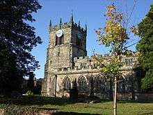 Church of St James |
| 5 Brookside Road | Barton-under-Needwood, East Staffordshire | House | Late Medieval | 10 December 1958 | SK1847218394 52°45′46″N 1°43′40″W |
1374402 | |
| Lower Booth Farmhouse | Blithfield, East Staffordshire | Farmhouse | 15th century | 12 January 1966 | SK0427027159 52°50′31″N 1°56′17″W |
1038401 | |
| Main Gateway to Blithfield Hall with Flanking Walls | Blithfield Park, Blithfield, East Staffordshire | Gate | c. 1820 | 8 August 1985 | SK0453623946 52°48′47″N 1°56′03″W |
1190043 | |
| The Orangery, Blithfield Hall | Blithfield, East Staffordshire | Orangery | c. 1769 | 12 January 1966 | SK0445723992 52°48′48″N 1°56′07″W |
1038399 | |
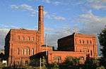
| Claymills Pumping Station | Burton-on-Trent, East Staffordshire | Sewage Pumping Station | 1886 | 3 January 1986 | SK2629425873 52°49′47″N 1°36′40″W |
1038427 | |
| Gates, Railings and Piers on West Side of Churchyard of Church of St Modwen | Burton-on-Trent, East Staffordshire | Gate | 19th century | 22 June 1979 | SK2505922722 52°48′05″N 1°37′47″W |
1038710 | .jpg) Gates, Railings and Piers on West Side of Churchyard of Church of St Modwen |
| The Abbey (Burton Abbey Club) | Burton-on-Trent, East Staffordshire | Abbey | 1004 | 24 March 1950 | SK2510722601 52°48′01″N 1°37′45″W |
1213613 | |
| 181 Horninglow Street | Burton-on-Trent, East Staffordshire | House | Regency | 24 March 1950 | SK2520323354 52°48′26″N 1°37′39″W |
1038699 | |
| 182, Horninglow Street | Burton-on-Trent, East Staffordshire | House | Early 19th century | 22 June 1979 | SK2521523353 52°48′26″N 1°37′39″W |
1374342 | |
| All Saints Vicarage | Denstone, East Staffordshire | Vicarage | 1860-2 | 30 May 1985 | SK0999940944 52°57′57″N 1°51′09″W |
1278479 | |
| Church of All Saints | Denstone, East Staffordshire | Church | 1949 | 30 May 1985 | SK1003740901 52°57′55″N 1°51′07″W |
1230657 | |
| Lodge about 20m north of Triumphal Arch at Quixhill | Denstone, East Staffordshire | Lodge | Early 19th century | 12 January 1966 | SK1006441303 52°58′08″N 1°51′06″W |
1230718 | .jpg) Lodge about 20m north of Triumphal Arch at Quixhill |
| Lodge about 20m south of Triumphal Arch at Quixhill | Denstone, East Staffordshire | Lodge | Early 19th century | 12 January 1966 | SK1005641266 52°58′07″N 1°51′06″W |
1230589 | Lodge about 20m south of Triumphal Arch at Quixhill |
| Triumphal Arch, Gates and Flanking Railings at Quixhill | Denstone, East Staffordshire | Gate | Early 19th century | 12 January 1966 | SK1005241286 52°58′08″N 1°51′06″W |
1230588 | Triumphal Arch, Gates and Flanking Railings at Quixhill |
| Church of St Mary | Dunstall, East Staffordshire | Parish Church | 1852-3 | 26 March 1986 | SK1874020430 52°46′52″N 1°43′25″W |
1038486 | .jpg) Church of St Mary |
| Dunstall Hall and attached Orangery | Dunstall, East Staffordshire | Country House | Early 19th century | 17 September 1952 | SK1906020452 52°46′53″N 1°43′08″W |
1038487 | |
| Calwich Abbey Temple Flanking Bridges with Gates, Gate Piers and Railings | Calwich Park, Ellastone, East Staffordshire | Gate | 1797 | 10 January 1953 | SK1317743174 52°59′09″N 1°48′19″W |
1230741 | |
| Church of St Peter | Ellastone, East Staffordshire | Church | 1586 | 12 January 1966 | SK1168043450 52°59′18″N 1°49′39″W |
1278444 | .jpg) Church of St Peter |
| Ellastone Old House | Upper Ellastone, Ellstone, East Staffordshire | House | Early to mid 18th century | 10 January 1953 | SK1173643273 52°59′12″N 1°49′36″W |
1230749 | 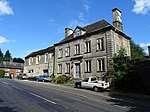 Ellastone Old House |
| Church of St Werburgh | Hanbury, East Staffordshire | Cross | Saxon | 12 March 1964 | SK1708427921 52°50′55″N 1°44′52″W |
1374435 | 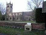 Church of St Werburgh |
| Pair of Gate Piers and Seats in Terrace Garden South of Hoar Cross Hall | Hoar Cross, East Staffordshire | Gate Pier | c. 1600 | 1 November 1989 | SK1234723047 52°48′17″N 1°49′06″W |
1374449 | 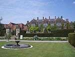 Pair of Gate Piers and Seats in Terrace Garden South of Hoar Cross Hall |
| Pair of Gatepiers and Gates to South Boundary of Terrace Garden at Hoar Cross Hall | Hoar Cross, East Staffordshire | Gate | c. 1700 | 1 November 1989 | SK1234623007 52°48′16″N 1°49′06″W |
1038479 | |
| Callowhill Hall | Kingstone, East Staffordshire | House | Late 17th century | 10 January 1953 | SK0497426388 52°50′06″N 1°55′39″W |
1374476 | 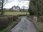 Callowhill Hall |
| Church of All Saints | Church Leigh, Leigh, East Staffordshire | Parish Church | Medieval | 12 January 1966 | SK0239035836 52°55′12″N 1°57′57″W |
1190204 | .jpg) Church of All Saints |
| Church View | Church Leigh, Leigh, East Staffordshire | House | C20 | 8 August 1985 | SK0251935726 52°55′08″N 1°57′50″W |
1038374 | |
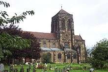
| Church of St Peter | Marchington, East Staffordshire | Parish Church | 1742 | 12 January 1966 | SK1379530728 52°52′26″N 1°47′47″W |
1190260 | .jpg) Church of St Peter |
| Marchington Hall | Marchington, East Staffordshire | House | c. 1690 | 10 January 1953 | SK1346931011 52°52′35″N 1°48′05″W |
1374504 | |
| Woodroffe's Cottage | Marchington, East Staffordshire | Jettied House | Early 17th century | 10 January 1953 | SK1120629894 52°51′59″N 1°50′06″W |
1038342 | |
| Old Hall Farmhouse | Picadilly, Mayfield, East Staffordshire | Farmhouse | 1680 | 30 May 1985 | SK1519346079 53°00′43″N 1°46′30″W |
1230785 | |
| Old Hall Farmhouse, Garden Wall and Gate Piers | Middle Mayfield, Mayfield, East Staffordshire | Farmhouse | 17th century | 10 January 1953 | SK1474644864 53°00′03″N 1°46′54″W |
1231004 | 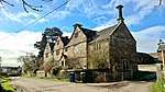 Old Hall Farmhouse, Garden Wall and Gate Piers |
| Church of All Saints | Okeover Park, Okeover, East Staffordshire | Church | 19th century | 12 January 1966 | SK1585148128 53°01′49″N 1°45′54″W |
1231030 | 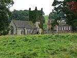 Church of All Saints |
| Gates and Railings enclosing South Side of Garden to West of Okeover Hall | Okeover Park, Okeover, East Staffordshire | Gate | c. 1740 | 10 January 1953 | SK1568648102 53°01′48″N 1°46′03″W |
1231108 | |
| Gates, Gate Piers, Steps and Walls to Kitchen Garden approx. 50 Yards North of Okeover Hall | Okeover Park, Okeover, East Staffordshire | Gate | Mid 18th century | 30 May 1985 | SK1579248247 53°01′53″N 1°45′58″W |
1278304 | |
| Gates, Piers and Railings immediately North East of Okeover Hall | Okeover Park, Okeover, East Staffordshire | Gate | c. 1738 | 30 May 1985 | SK1583048140 53°01′49″N 1°45′55″W |
1231116 | |
| Inner Gate Piers, Gates and Railings to Okeover Hall | Okeover Park, Okeover, East Staffordshire | Gate | 1756-9 | 30 May 1985 | SK1586848161 53°01′50″N 1°45′53″W |
1231033 | |
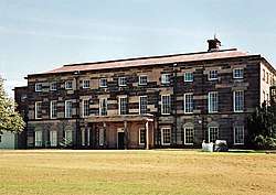
| Okeover Hall | Okeover Park, Okeover, East Staffordshire | Country House | 1745-9 | 10 January 1953 | SK1580048118 53°01′48″N 1°45′57″W |
1231031 | |
| Outer Gates and Gate Piers to Okeover Hall | Okeover Park, Okeover, East Staffordshire | Gate | c. 1740 | 30 May 1985 | SK1612048153 53°01′50″N 1°45′40″W |
1277410 | .jpg) Outer Gates and Gate Piers to Okeover Hall |
| Statue, Sundial and Steps approx. 30 Yards North of Okeover Hall | Okeover Park, Okeover, East Staffordshire | Steps | 1741 | 30 May 1985 | SK1583648166 53°01′50″N 1°45′55″W |
1278305 | |
| Temple of Pomona, Okeover Hall | Okeover Park, Okeover, East Staffordshire | Pavilion | c1737-48 | 30 May 1985 | SK1583148296 53°01′54″N 1°45′55″W |
1231036 | |
| Gate Piers and Courtyard Walls to East of Wootton Lodge | Wootton Park, Ramshorn, East Staffordshire | Gate | 17th century | 10 January 1953 | SK0964043792 52°59′29″N 1°51′28″W |
1231038 | |
| Pair of Pavilions to North East and South East Corners of Courtyard East of Wootton Lodge | Wootton Park, Ramshorn, East Staffordshire | Pavilion | 17th century | 10 January 1953 | SK0963243774 52°59′28″N 1°51′29″W |
1278309 | |
| Banks Farmhouse | Rocester, East Staffordshire | Farmhouse | Early 18th century | 12 January 1966 | SK0990838959 52°56′53″N 1°51′14″W |
1231926 | |
| Cross approximately 40 Yards North of Church of St Michael | Rocester, East Staffordshire | Cross | 13th century | 12 January 1966 | SK1117039394 52°57′07″N 1°50′07″W |
1231920 | .jpg) Cross approximately 40 Yards North of Church of St Michael |
| Church of St Paul | Shobnall, East Staffordshire | Parish Church | 1874 | 24 March 1950 | SK2390523462 52°48′29″N 1°38′49″W |
1288714 | |
| Sinai Park | Shobnall, East Staffordshire | Farmhouse | Mid 17th century | 17 September 1952 | SK2222123097 52°48′18″N 1°40′19″W |
1038484 | |
| Church of St Mary | Stretton, East Staffordshire | Parish Church | 1895-7 | 12 March 1963 | SK2537426354 52°50′03″N 1°37′29″W |
1293648 | |
| Church of All Saints | Tatenhill, East Staffordshire | Chapel of Ease | 1866-7 | 26 March 1986 | SK1805522965 52°48′14″N 1°44′01″W |
1038436 | .jpg) Church of All Saints |
| Church of St Michael | Tatenhill, East Staffordshire | Parish Church | 13th century | 12 March 1964 | SK2054422076 52°47′45″N 1°41′48″W |
1038433 | 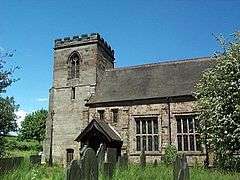 Church of St Michael |
| The Old Rectory | Tatenhill, East Staffordshire | House | 1999 | 17 September 1952 | SK2055222101 52°47′46″N 1°41′48″W |
1038432 | |
| Dog and Partridge Hotel | Tutbury, East Staffordshire | Coaching Inn | Late C15-Early 16th century | 17 September 1952 | SK2126628898 52°51′26″N 1°41′08″W |
1188498 | 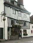 Dog and Partridge Hotel |
| Bank House | Uttoxeter, East Staffordshire | House | Late 18th century | 24 October 1950 | SK0932033524 52°53′57″N 1°51′46″W |
1374326 | |
| Dove Bridge | Uttoxeter, East Staffordshire | Road Bridge | 15th century | 13 September 1967 | SK1055634465 52°54′27″N 1°50′40″W |
1237731 | 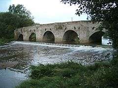 Dove Bridge |
| Parish Church of St Mary | Uttoxeter, East Staffordshire | Parish Church | 14th century | 24 October 1950 | SK0932833485 52°53′55″N 1°51′46″W |
1038783 | 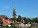 Parish Church of St Mary |
| The Manor House | Uttoxeter, East Staffordshire | House | Pre 1500 | 24 October 1950 | SK0907033749 52°54′04″N 1°52′00″W |
1293560 | |
| 25 Market Place | Uttoxeter, East Staffordshire | Timber Framed House | Medieval | 8 January 1983 | SK0923933372 52°53′52″N 1°51′51″W |
1372432 | |
| Loxley Hall | Loxley Park, Uttoxeter Rural, East Staffordshire | House | Earlier than early 19th century | 10 January 1953 | SK0613232123 52°53′12″N 1°54′37″W |
1190360 | |
| Church of St Leonard | Wychnor, East Staffordshire | Parish Church | 12th century | 12 March 1964 | SK1768816074 52°44′31″N 1°44′22″W |
1038440 | 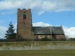 Church of St Leonard |
| Church of St Peter | Yoxall, East Staffordshire | Parish Church | 13th century | 12 March 1964 | SK1417019042 52°46′08″N 1°47′29″W |
1374422 | 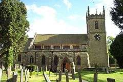 Church of St Peter |
| Pear Tree Farmhouse | Yoxall, East Staffordshire | Farmhouse | Circa 14th century | 28 October 1998 | SK1423719305 52°46′16″N 1°47′26″W |
1038475 | |
| Burton upon Trent War Memorial | Burton upon Trent | War memorial | 1922 | 22 June 1979 | SK2497322594 52°48′01″N 1°37′52″W |
1288788 | .jpg) Burton upon Trent War Memorial |
.jpg)
.jpg)
Notes
- The date given is the date used by Historic England as significant for the initial building or that of an important part in the structure's description.
- Sometimes known as OSGB36, the grid reference is based on the British national grid reference system used by the Ordnance Survey.
- The "List Entry Number" is a unique number assigned to each listed building and scheduled monument by Historic England.
gollark: I see.
gollark: Notably, English words do not actually mean the same thing as the roots might imply, in cases where there even are obvious ones.
gollark: Just because your language theoretically has words composed of subwords doesn't mean you can ignore the various problems I mentioned (except possibly the grammar one). And "convert the words to semantic expressions" hides a lot of the complexity this would involve.
gollark: I'm pretty sure I've seen diagrams of pronounceable things of some kind, but they're more complex than just permutations of "high tone, low tone" and do not conveniently map to concepts.
gollark: What do you mean "all of the possible forms of a square diagram with two or more sides"? There are infinitely many of those. And how do I just pronounce a diagram without a predetermined mapping?
External links
![]()
This article is issued from Wikipedia. The text is licensed under Creative Commons - Attribution - Sharealike. Additional terms may apply for the media files.