Grade II* listed buildings in Borough of Milton Keynes
There are over 20,000 Grade II* listed buildings in England. This page is a list of these buildings in the district of Borough of Milton Keynes in Buckinghamshire.
List
| Name | Location | Type | Completed [note 1] | Date designated | Grid ref.[note 2] Geo-coordinates |
Entry number [note 3] | Image |
|---|---|---|---|---|---|---|---|
| Church of St Peter | Astwood, Milton Keynes | Parish Church | 14th century | 17 November 1966 | SP9505247374 52°06′59″N 0°36′48″W |
1289631 | 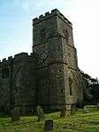 Church of St Peter |
| Church of St Martin | Fenny Stratford, Bletchley and Fenny Stratford | Church | 1724-30 | 28 June 1954 | SP8825434069 51°59′53″N 0°42′57″W |
1125422 | 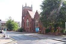 Church of St Martin |
| 11 and 13 Watling Street | Fenny Stratford, Bletchley and Fenny Stratford | House | C16/C17 | 26 September 1975 | SP8830034058 51°59′53″N 0°42′55″W |
1125436 |  |
| Church of All Saints | Bow Brickhill | Church | Earlier | 17 November 1966 | SP9114734401 52°00′02″N 0°40′25″W |
1212249 | 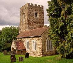 Church of All Saints |
| Bradwell House | Bradwell | House | Early 18th century | 17 November 1966 | SP8331339724 52°02′59″N 0°47′11″W |
1159875 | |
| Church of St Lawrence | Bradwell | Church | Restored | 17 November 1966 | SP8314239472 52°02′51″N 0°47′21″W |
1310793 | 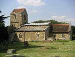 Church of St Lawrence |
| Church of All Saints | Calverton | Parish Church | 1818-1824 | 12 June 1953 | SP7902939018 52°02′38″N 0°50′57″W |
1125411 | 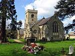 Church of All Saints |
| Manor Farm House | Lower Weald, Calverton | Farmhouse | Late 15th century or early 16th century | 12 June 1953 | SP7902939100 52°02′41″N 0°50′57″W |
1125412 | |
| The Woolstones Community Centre | Little Woolstone, Campbell Park | Bell Tower | 14th century | 17 November 1966 | SP8756339290 52°02′42″N 0°43′29″W |
1125230 | |
| Dovecote South of Chicheley Hall | Chicheley | Dovecote | 18th century | 3 March 1952 | SP9047845777 52°06′11″N 0°40′50″W |
1212329 | |
| Service Wing with attached Quadrant Link North West of Chicheley Hall | Chicheley | House | 1952 | 3 March 1952 | SP9055145907 52°06′15″N 0°40′46″W |
1289598 | |
| Stable Block South West of Chicheley Hall | Chicheley | Country House | 1723-25 | 3 March 1952 | SP9051445825 52°06′12″N 0°40′48″W |
1212279 | |
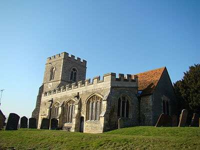
| Church of St Mary | Cold Brayfield | Parish Church | 12th century | 17 November 1966 | SP9293152248 52°09′38″N 0°38′34″W |
1212337 | 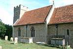 Church of St Mary |
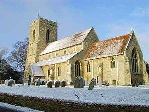
| Church of All Saints | Emberton | Parish Church | c. 1340 | 17 November 1966 | SP8849649456 52°08′11″N 0°42′30″W |
1115943 | 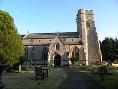 Church of All Saints |
| Former Servants Lavatory at Gayhurst House (part of 12 Gayhurst Court Mews) | Gayhurst | Toilet | 1859-60 | 27 February 1984 | SP8453546250 52°06′29″N 0°46′01″W |
1320166 | |
| Gayhurst Court Mews | Gayhurst | House | 1984 | 17 November 1966 | SP8455346223 52°06′28″N 0°46′01″W |
1211955 | |
| Gayhurst Court Mews (the Dovecote) and attached Gate Piers | Gayhurst | House | 1966 | 17 November 1966 | SP8461646146 52°06′26″N 0°45′57″W |
1115911 | |
| Stone Pedestal to North West and South East of Gayhurst House (Gayhurst Court) | Gayhurst | Column | c. 1860 | 27 February 1984 | SP8460946263 52°06′30″N 0°45′58″W |
1115913 | |
| The Subway | Gayhurst | Gate | Before 1793 | 17 November 1966 | SP8473546913 52°06′51″N 0°45′50″W |
1320183 | |
| Church of St Andrew | Great Linford | Church | 13th century | 17 November 1966 | SP8507242323 52°04′22″N 0°45′37″W |
1160090 | 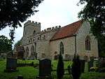 Church of St Andrew |
| Former School House and Almhouses | Great Linford | House | 1952 | 3 March 1952 | SP8513342309 52°04′21″N 0°45′34″W |
1125275 | |
| Linford Manor | Great Linford | Country House | c. 1680 | 3 March 1952 | SP8524042272 52°04′20″N 0°45′28″W |
1125276 | 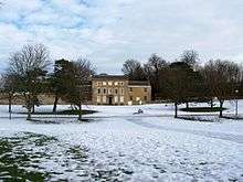 Linford Manor |
| Stable Blocks, to West of Linford Manor | Great Linford | Stable | c. 1720 | 17 November 1966 | SP8512142270 52°04′20″N 0°45′34″W |
1310704 | |
| Church of St Leonard and St Andrew | Little Linford, Haversham-cum-Little Linford | Parish Church | Early 13th century | 17 November 1966 | SP8459444214 52°05′23″N 0°46′00″W |
1212140 | |
| Haversham Grange | Haversham, Haversham-cum-Little Linford, Milton Keynes | Farmhouse | 14th century | 3 March 1952 | SP8307243124 52°04′49″N 0°47′21″W |
1212158 | |
| Church of St Mary Magdalen | Little Brickhill | Parish Church | 14th century | 17 November 1966 | SP9103432455 51°58′59″N 0°40′33″W |
1212666 | 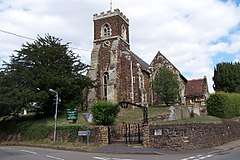 Church of St Mary Magdalen |
| Church of All Saints | Loughton | Church | C13-15 | 17 November 1966 | SP8375337881 52°01′59″N 0°46′50″W |
1310657 | |
| Manor Farmhouse | Loughton | Farmhouse | About 1580 | 3 March 1952 | SP8339137831 52°01′57″N 0°47′09″W |
1332300 | |
| 22 | Milton Keynes Village, Milton Keynes | House | 14th century or earlier | 21 May 1986 | SP8892939098 52°02′35″N 0°42′17″W |
1125199 | |
| Church of St James | New Bradwell | Church | 1857-60 | 28 October 1976 | SP8282941469 52°03′55″N 0°47′35″W |
1125329 | 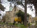 Church of St James |
| 84 High Street | Newport Pagnell | House | Early 18th century | 24 July 1969 | SP8746143904 52°05′12″N 0°43′30″W |
1125472 | |
| Church of St Nicholas | Newton Blossomville | Parish Church | C12-C15 | 17 November 1966 | SP9257651581 52°09′17″N 0°38′54″W |
1212987 | 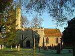 Church of St Nicholas |
| Gilpin House, Orchard Side Cowper and Newton Museum | Olney | House | Early 18th century | 3 March 1952 | SP8897551272 52°09′09″N 0°42′03″W |
1125295 | |
| Olney Wine Bar and Cross Keys House | Olney | House | Early 18th century | 3 March 1952 | SP8889951176 52°09′06″N 0°42′07″W |
1332279 | |
| Orchard House including Front Railings | Olney | House | Built 18th century | 6 May 1983 | SP8890951652 52°09′22″N 0°42′07″W |
1222060 | |
| The Vicarage including attached Coachhouse | Olney | Vicarage | Early 18th century | 3 March 1952 | SP8898851118 52°09′04″N 0°42′03″W |
1158059 | 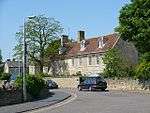 The Vicarage including attached Coachhouse |
| Church of St Giles | Tattenhoe, Shenley Brook End | Church | 16th century | 19 August 1959 | SP8290633955 51°59′52″N 0°47′38″W |
1125221 | 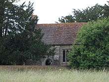 Church of St Giles |
| Church of St Thomas | Simpson | Church | Late 13th century | 28 June 1954 | SP8833336199 52°01′02″N 0°42′51″W |
1160223 | 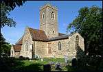 Church of St Thomas |
| Burnham House | Stony Stratford | House | Earlier | 12 October 1954 | SP7875840185 52°03′16″N 0°51′10″W |
1160550 | |
| Parish Church of St Mary and St Giles | Stony Stratford | Parish Church | 1487 | 12 June 1953 | SP7870240464 52°03′25″N 0°51′13″W |
1125375 | 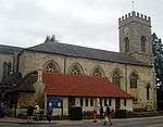 Parish Church of St Mary and St Giles |
| The Bull Hotel | Stony Stratford | House | Late 18th century | 12 June 1953 | SP7871140504 52°03′26″N 0°51′12″W |
1332253 | 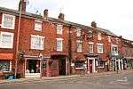 The Bull Hotel |
| The Cock Hotel | Stony Stratford | Inn | Pre 1742 | 12 June 1953 | SP7868640526 52°03′27″N 0°51′14″W |
1310973 | 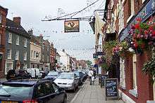 The Cock Hotel |
| Tower of Church of St Mary Magdalene | Stony Stratford | Tower | Late 13th century | 12 June 1953 | SP7858040648 52°03′31″N 0°51′19″W |
1310932 | 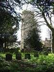 Tower of Church of St Mary Magdalene |
| 48 High Street | Stony Stratford | Timber Framed House | Early 17th century | 12 June 1953 | SP7875740468 52°03′25″N 0°51′10″W |
1311040 | |
| 75 High Street | Stony Stratford | House | Late 18th century | 12 June 1953 | SP7863540535 52°03′27″N 0°51′16″W |
1125378 | |
| 92 and 94 High Street | Stony Stratford | Coaching Inn | Early-mid 18th century | 12 June 1953 | SP7859840597 52°03′29″N 0°51′18″W |
1159586 | |
| 12 and 13 Market Square | Stony Stratford | House | Later 17th century | 12 June 1953 | SP7864940321 52°03′21″N 0°51′16″W |
1332270 | |
| Church of St Peter | Tyringham, Tyringham and Filgrave | Parish Church | 12th century | 17 November 1966 | SP8593146699 52°06′43″N 0°44′48″W |
1115848 | 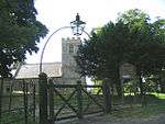 Church of St Peter |
| The Bathing Pavilion at Tyringham Hall | Tyringham, Tyringham and Filgrave | Summerhouse | 1926 | 3 March 1952 | SP8547046973 52°06′52″N 0°45′12″W |
1320232 | |
| The Temple of Music at Tyringham Hall | Tyringham, Tyringham and Filgrave | Summerhouse | 1926 | 3 March 1952 | SP8551947018 52°06′54″N 0°45′09″W |
1115852 | |
| St Michael's Church of the Open University | Walton | University | 1966 | 17 November 1966 | SP8848536885 52°01′24″N 0°42′43″W |
1160855 | 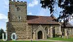 St Michael's Church of the Open University |
| Church of St Mary | Wavendon | Parish Church | 13th century | 17 November 1966 | SP9115237199 52°01′33″N 0°40′22″W |
1289169 | |
| Wavendon House | Wavendon | Country House | Late 17th century | 16 February 1984 | SP9242637632 52°01′46″N 0°39′15″W |
1289190 | |
| Bletchley Rectory Cottages and Museum | West Bletchley | Hall House | 1447 | 26 September 1975 | SP8632633620 51°59′40″N 0°44′39″W |
1160103 | |
| Cowpers House | Weston Underwood | House | 17th century | 3 March 1952 | SP8645050532 52°08′47″N 0°44′17″W |
1320237 | |
| Church of St George the Martyr | Wolverton, Wolverton and Greenleys | Church | 1843 | 28 October 1976 | SP8183041077 52°03′43″N 0°48′28″W |
1125328 | 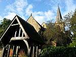 Church of St George the Martyr |
| Church of the Holy Trinity | Old Wolverton, Wolverton and Greenleys | Parish Church | 14th century | 12 June 1953 | SP8032241300 52°03′51″N 0°49′47″W |
1125323 | 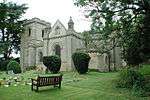 Church of the Holy Trinity |
| Railway Bridge (171c) Grand Union Canal | Wolverton, Wolverton and Greenleys | Railway Bridge | 1834-5 | 23 May 2001 | SP8188841440 52°03′55″N 0°48′25″W |
1246107 | 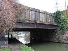 Railway Bridge (171c) Grand Union Canal |
| Church of St Mary | Woughton on the Green | Church | 13th century | 17 November 1966 | SP8768837596 52°01′47″N 0°43′24″W |
1161141 | 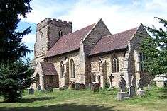 Church of St Mary |
Notes
- The date given is the date used by Historic England as significant for the initial building or that of an important part in the structure's description.
- Sometimes known as OSGB36, the grid reference is based on the British national grid reference system used by the Ordnance Survey.
- The "List Entry Number" is a unique number assigned to each listed building and scheduled monument by Historic England.
gollark: Just check dynmap.
gollark: I see.
gollark: hi.
gollark: I am the shareholders, of course.
gollark: Idea: put me in charge of dynmap management.
External links
![]()
This article is issued from Wikipedia. The text is licensed under Creative Commons - Attribution - Sharealike. Additional terms may apply for the media files.