British Columbia Highway 7B
Highway 7B, known as the Mary Hill Bypass, is a 7.27 km (4.52 mi) long riverside east-west link between the cities of Coquitlam to the west and Port Coquitlam to the east. The Mary Hill Bypass gained its '7B' designation in 1996, when it was widened from two to four lanes. Highway 7B meets Highway 7 at both of its ends, and also links to Highway 1 within Coquitlam at the Cape Horn Interchange.
| ||||
|---|---|---|---|---|
| Mary Hill Bypass | ||||
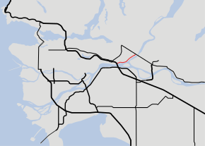 Highway 7B highlighted in red | ||||
| Route information | ||||
| Length | 7.27 km[1] (4.52 mi) | |||
| Existed | 1996–present | |||
| Major junctions | ||||
| West end | ||||
| East end | ||||
| Location | ||||
| Major cities | Coquitlam, Port Coquitlam | |||
| Highway system | ||||
British Columbia provincial highways
| ||||

Route details
The Mary Hill Bypass skirts around Mary Hill, which was developed in the early 1960s for residential housing. The Mary Hill Bypass begins at an intersection with United Boulevard in Coquitlam. Just west of this intersection are the ramps that connect Highway 1 and Highway 7 (westbound only). Highway 1 and Highway 7 eastbound could be accessed via United Boulevard. After crossing the Coquitlam River, the highway continues on, turning east and passing through a major intersection which provides access to downtown Port Coquitlam. Continuing northeast, the Mary Hill Bypass passes through another major intersection, then enters an industrial park and passes through another three intersections. After passing a railway underpass and one final intersection, the Mary Hill Bypass ends at Highway 7, which continues east to Pitt Meadows, Maple Ridge, and Mission. In the mid-1990s, the Mary Hill Bypass underwent a major improvement which included 4 laning and intersection upgrades.
Related routes
North Fraser Perimeter Road
As part of the Ministry of Transportation's Metro Vancouver Gateway Program,[2] improvements to existing roads around the north side of the Fraser River between the Queensborough Bridge in New Westminster and the Golden Ears Bridge in Maple Ridge. This project was known as the North Fraser Perimeter Road, including the upgrading of intersections and possible interchanges along the Mary Hill Bypass[3] and construction of the new, cable-stayed Pitt River Bridge.[4] While the new Pitt River Bridge was constructed, the remainder of the North Fraser Perimeter Road was cancelled.[5][6]
United Boulevard
United Boulevard is a major roadway in Coquitlam used as connection between Highway 7B and Highways 1 and 7. A 1.3 km (0.8 mi) segment is provincially maintained as part of Highway 7B;[1] however, the section is unsigned and the western terminus of Highway 7B is signed as being at the Mary Hill Bypass / United Boulevard interchange.[7][8]
Major intersections
From west to east; list excludes United Boulevard. The entire route is in Metro Vancouver.
| Location | km[1] | mi | Destinations | Notes | |
|---|---|---|---|---|---|
| Coquitlam | 0.00 | 0.00 | Cape Horn Interchange | ||
| Port Coquitlam | 1.90 | 1.18 | Shaughnessy Street | ||
| 4.10 | 2.55 | Pitt River Road | |||
| 5.03 | 3.13 | Broadway Street | |||
| 6.24 | 3.88 | Kingsway Avenue | |||
| 7.27 | 4.52 | Interchange | |||
| 1.000 mi = 1.609 km; 1.000 km = 0.621 mi | |||||
References
- Landmark Kilometre Inventory (PDF). British Columbia Ministry of Transportation and Infrastructure (Report). Cypher Consulting. July 2016. p. 201. Archived from the original (PDF) on 2017-03-11. Retrieved 2017-03-23.
- "Gateway Program". Government of British Columbia. Archived from the original on December 12, 2009. Retrieved December 20, 2007.
- "North Fraser Perimeter Road". Government of British Columbia. Archived from the original on December 6, 2009. Retrieved December 20, 2007.
- "Pitt River Bridge and Mary Hill Interchange Project". Government of British Columbia. Archived from the original on December 2, 2009. Retrieved December 20, 2007.
- "TransLink puts major road expansion on hold". CBC News. May 20, 2011. Retrieved March 22, 2017.
- McManus, Theresa (June 9, 2013). "New Westminster balks at suggestion of United Boulevard extension". New Westminster Record. Retrieved March 22, 2017.
- "Hwy 7B at United Blvd". Google Street View. Google. September 2015. Retrieved March 23, 2017.
- "Hwy 7 at United Blvd". Google Street View. Google. June 2016. Retrieved March 23, 2017.