British Columbia Highway 101
Highway 101, also known as the Sunshine Coast Highway is the main north-south thoroughfare on the Sunshine Coast, British Columbia, Canada. Highway 101, which first opened in 1962, is divided into two separate land segments, with a ferry link in between. The highway is maintained by Capilano Highway Services.[2] Despite its location on the mainland, the highway is only accessible to the rest of the British Columbia highway system via ferry. Highway 101 between Langdale and Powell River is designated as a feeder route of the Canadian National Highway System.[3]
| ||||
|---|---|---|---|---|
| Sunshine Coast Highway | ||||
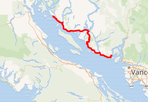
Highway 101 highlighted in red. | ||||
| Route information | ||||
| Length | 156 km[1] (97 mi) | |||
| Existed | 1962–present | |||
| Major junctions | ||||
| South end | ||||
| North end | Lund | |||
| Location | ||||
| Districts | Sechelt | |||
| Major cities | Powell River | |||
| Towns | Gibsons | |||
| Highway system | ||||
British Columbia provincial highways
| ||||

Route description
The total distance of Highway 101, including the ferry link, is approximately 156 kilometres (97 mi). The highway begins in the south at the BC Ferries terminal at Langdale, which connects the Sunshine Coast to Vancouver via a ferry route across Howe Sound to Horseshoe Bay. The southern land section of Highway 101 is 80 kilometres (50 mi) long, and includes from south to north, the communities of Gibsons, Roberts Creek, Sechelt, Halfmoon Bay and Pender Harbour. The ferry link across the Jervis Inlet lasts 9.5 nautical miles (17.6 km) between Earls Cove to the south and Saltery Bay to the north.[4] The 59-kilometre-long (37 mi) northern land section of Highway 101 includes, from southeast to northwest, the hamlets of Stillwater and Lang Bay, the city of Powell River, and the community of Lund, at the northern terminus of the highway.
Major intersections
From south to north:
| Regional district | Location | km[1] | mi | Destinations | Notes |
|---|---|---|---|---|---|
| Sunshine Coast | Langdale | 0.00 | 0.00 | ||
| 0.93 | 0.58 | Marine Drive (Hwy 912:2566 south) / Port Mellon Highway (Hwy 912:2565 north) – Gibsons, Port Mellon | |||
| Gibsons | 4.07 | 2.53 | Reed Road | ||
| 4.89 | 3.04 | Gibsons Way, School Road | Hwy 101 branches west | ||
| 6.10 | 3.79 | Pratt Road, Payne Road | |||
| Roberts Creek | 15.40 | 9.57 | Roberts Creek Road | ||
| Sechelt | 41.25 | 25.63 | Field Road | ||
| Sechelt First Nation | 25.80 | 16.03 | Ti'Ta Way | ||
| Sechelt | 26.26 | 16.32 | Dolphin Street, Wharf Avenue | ||
| 28.84 | 17.92 | Norwest Bay Road | |||
| Madeira Park | 58.09 | 36.10 | Madeira Park Road (Hwy 912:2573 north) | ||
| Earls Cove | 80.29 | 49.89 | Earls Cove ferry terminal | ||
| Jervis Inlet | Approximately 17.6 km (9.5 nmi)[4] | ||||
| Powell River | Saltery Bay | 97.89 | 60.83 | Saltery Bay ferry terminal | |
| Powell River | 125.11 | 77.74 | Joyce Avenue | ||
| 128.67 | 79.95 | Access to Texada Island and Comox via ferry | |||
| 129.61 | 80.54 | Alberni Street, Abbotsford Street | |||
| 133.66 | 83.05 | Arbutus Avenue, Marine Avenue | |||
| Lund | 156.36 | 97.16 | |||
1.000 mi = 1.609 km; 1.000 km = 0.621 mi
| |||||
References
- Landmark Kilometre Inventory (PDF). British Columbia Ministry of Transportation and Infrastructure (Report). Cypher Consulting. July 2017. pp. 590–597.
- "Highway Maintenance". Capilano Highway Services. Retrieved December 7, 2017.
- National Highway System (PDF). Ministry of Transportation and Infrastructure (Report). Government of British Columbia. p. 3. Retrieved December 7, 2017.
- "BC Ferries Schedules: Sechelt - Powell River (Earls Cove-Saltery Bay)". BC Ferries. Retrieved December 7, 2017.