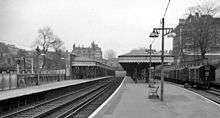
Blackheath railway station
Blackheath railway station is Grade II-listed and is in the south-centre of Blackheath, a village in southeast London. In traditional terms the area immediately south-west of the station around Lee Terrace and Lee Park is part of Lee;[3] a status challenged by the station's naming, buildings such as the Blackheath Halls and the development of Blackheath Park to the south east. It is 8 miles 52 chains (13.9 km) measured from London Victoria.
| Blackheath | |
|---|---|
 Blackheath Location of Blackheath in Greater London | |
| Location | Blackheath |
| Local authority | London Borough of Lewisham |
| Managed by | Southeastern |
| Station code | BKH |
| DfT category | C2 |
| Number of platforms | 2 |
| Accessible | Yes |
| Fare zone | 3 |
| National Rail annual entry and exit | |
| 2014–15 | |
| – interchange | |
| 2015–16 | |
| – interchange | |
| 2016–17 | |
| – interchange | |
| 2017–18 | |
| – interchange | |
| 2018–19 | |
| – interchange | |
| Key dates | |
| 30 July 1849 | Opened |
| Listed status | |
| Listed feature | Blackheath Railway Station |
| Listing grade | II |
| Entry number | 1358479[2] |
| Added to list | 12 March 1973 |
| Other information | |
| External links | |
| WGS84 | 51.4658°N 0.0089°E |
The tracks run through the village and are crossed by a road overbridge on which the station buildings stand.

Much of the original station, dating back at track level to 1849 and at ticket office level to 1879, remains. It was built using London bricks to a design by George Smith (who also built Greenwich station). At the "country" end of the platforms the lines branch off to the North Kent and Bexleyheath lines. The former passes through the one mile long (1.6 km) Blackheath Tunnel immediately after the junction; the latter through the shorter Kidbrooke Tunnel after a short cutting.
Blackheath's station has two platforms which are partially covered with a weather canopy. Glass and metal waiting shelters were erected on the London ends of both platforms in April 2018. The downside platform has a disused platform face (bay platform) facing towards London, used in earlier days by commuter trains terminating here. Unusually, the track in the bay remains in situ, although it is now heavily overgrown and otherwise obstructed. The area to the north (now a car park) was formerly an area of railway sidings, where the commuter trains were stabled when out of service.
The bay platform used to come into its own when a circus was taking place on Blackheath. Many of the animals would arrive in railway box vans. The circus would then proceed through Blackheath Village on to the heath.
The station cannot be relied upon as a way of reaching Blackheath during November's traditional free fireworks display, as it is normally closed early on that day for safety reasons. Conversely, in April, on the Sunday of the London Marathon, it is crucial in enabling athletes and their supporters to reach the starting line, as on that day bus services across the heath are usually suspended as the roads are closed.
Blackheath Halls, run by Trinity Laban Conservatoire of Music and Dance, and The Conservatoire are approximately 100m south of the station.
Services
The typical off-peak service from the station is:
- 4tph (trains per hour) to London Charing Cross.
- 2tph to Cannon Street.
- 2tph to London Victoria via Denmark Hill.
- 2tph to Slade Green then returning to Cannon Street via Woolwich Arsenal and Greenwich.
- 2tph to Dartford via Bexleyheath.
- 2tph to Dartford via Woolwich Arsenal.
- 2tph to Gravesend
| Preceding station | Following station | |||
|---|---|---|---|---|
| Lewisham | Southeastern North Kent Line |
Charlton | ||
| Southeastern Bexleyheath line & Victoria-Dartford Line |
Kidbrooke | |||
Facilities
There is an adjacent car park to the north of the station (with 205 spaces) and another nearby off Blackheath Grove. Both are managed by the local authority. Charges apply 365 days a year at all times.
Connections
London Buses routes 54, 89, 108 and 202 and night route N89 serve the station.
References
- "Station usage estimates". Rail statistics. Office of Rail Regulation. Please note: Some methodology may vary year on year.
- Historic England. "Details from listed building database (1358479)". National Heritage List for England. Retrieved 8 June 2015.
- https://www.achurchnearyou.com/search/?lat=51.463&lon=-0 St Margaret's, Lee, map of parish, Church of England, retrieved 2019-08-11.
| Wikimedia Commons has media related to Blackheath railway station. |