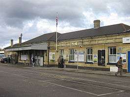
Orpington railway station
Orpington railway station is on the South Eastern Main Line, serving the town of Orpington in the London Borough of Bromley, south-east London. It is 13 miles 65 chains (22.2 km) down the line from London Charing Cross and is situated between Petts Wood and Chelsfield stations. It is in Travelcard Zone 6.
| Orpington | |
|---|---|
 The station building in 2007 | |
 Orpington Location of Orpington in Greater London | |
| Location | Orpington |
| Local authority | London Borough of Bromley |
| Managed by | Southeastern |
| Station code | ORP |
| DfT category | C2 |
| Number of platforms | 8 |
| Accessible | Yes[1] |
| Fare zone | 6 |
| National Rail annual entry and exit | |
| 2014–15 | |
| 2015–16 | |
| 2016–17 | |
| – interchange | 1.154 million[2] |
| 2017–18 | |
| – interchange | |
| 2018–19 | |
| – interchange | |
| Key dates | |
| 2 March 1868 | Opened |
| 1904 | Rebuilt |
| 1925 | Electrification |
| Other information | |
| External links | |
| WGS84 | 51.3741°N 0.0885°E |
The station has eight platforms. Platform 1 is a bay platform which is only occasionally used for Thameslink services. Platform 2 is used for fast services to Charing Cross or Cannon Street . Platforms 3 and 4 are an island, 3 used by trains towards Ashford International or Tunbridge Wells and 4 by stopping services from Sevenoaks to Charing Cross or Cannon Street. Platform 5 hosts the Sevenoaks slows with platforms 6-8 being bay platforms used by services starting at Orpington towards Charing Cross, London Victoria, Cannon Street and Luton/Bedford. At the country end, the four tracks become two. At the London end there is a four-road sidings, where trains are stabled and cleaned.
There are two entrances, both with ticket offices and ticket barriers, the main one on the platform 1/2 side (Crofton Road), the other on the platforms 5-8 side (Station Approach and the bus interchange). Access to platforms is via an underground subway (unsuitable for wheelchair users) or via a new bridge opened in 2008 which incorporates lift access to all platforms.
History
The station was opened on 2 March 1868 by the South Eastern Railway (SER),[3] when the SER opened its cut-off line between Chislehurst and Sevenoaks. Previously, trains between London and Tunbridge Wells had taken a circuitous route via Redhill. The line was widened and the station rebuilt in 1904, expanding to six platforms. Third rail electrification reached Orpington in 1925, and extended to Sevenoaks in 1935.[4] About this time the Southern Heights Light Railway was proposed, which would have diverged from the main line south of Orpington and finished at Sanderstead.[5] Crofton Roman Villa was partly destroyed by a railway cutting in the late 1800s but was rediscovered in 1926 when work was carried out to the area to the west of the station entrance as an entrance to a new council building. Platforms 7 and 8 were built in the early 1990s on the site of former carriage sidings. In 2008, the station became fully accessible following the opening of a new footbridge providing lift access to all platforms. In 2013, the former steam locomotive shed (closed for steam in 1926; in use as sidings until 1960) is still standing, converted to offices (sited adjacent to platform 8). In 2014 the car park was rebuilt with 2 storeys to increase capacity.
Services
Services are operated by Southeastern and Thameslink.
As of December 2019, the typical off-peak service is:[6][7][8][9]
- 2tph (trains per hour) to London Victoria via Herne Hill
- 2tph to Kentish Town via Catford
- 4tph to London Charing Cross (Semi fast)
- 2tph to London Charing Cross via Grove Park
- 2tph to London Cannon Street via Grove Park & Lewisham
- 2tph to Sevenoaks
- 4tph to Tunbridge Wells, with 2tph continuing to Hastings
| Preceding station | Following station | |||
|---|---|---|---|---|
| London Bridge | Southeastern South Eastern main line |
Sevenoaks | ||
| Petts Wood | Southeastern Grove Park line |
Chelsfield or Terminus | ||
| Southeastern Bromley South line |
Terminus | |||
| Thameslink Kentish Town to Orpington |
||||
Connections
London Buses routes 51, 61, 208, 353, 358, B14, R1, R2, R3, R4, R5, R6, R7, R8, R9, R10, school routes 654, 684, night route N199 and Arriva Kent Thameside route 477 serve the station.[10]
References
- "Southeastern wheelchair and scooter guide" (PDF). Southeastern. May 2009. Retrieved 20 June 2017.
- "Station usage estimates". Rail statistics. Office of Rail Regulation. Please note: Some methodology may vary year on year.
- Butt, R.V.J. (1995). The Directory of Railway Stations. Yeovil: Patrick Stephens Ltd. p. 178. ISBN 1-85260-508-1. R508.CS1 maint: ref=harv (link)
- Southern Electric by G.T.Moody page 56
- "Southern Heights Railway". The Times (45098). London. 11 January 1929. col D, p. 9.
- "Timetable 4 - London to Tunbridge Wells and Hastings" (PDF). Southeastern, December 2019.
- "Timetable 6 - London to Grove Park, Orpington and Sevenoaks" (PDF). Southeastern, December 2019.
- "Timetable 7 - London to Bromley South and Orpington" (PDF). Southeastern, December 2019.
- "Timetable 05 - Luton to Orpington" (PDF). Thameslink, December 2019.
- "Buses from Orpington" (PDF). TfL. 5 December 2017. Retrieved 2 June 2020.
External links
| Wikimedia Commons has media related to Orpington railway station. |
- Train times and station information for Orpington railway station from National Rail