47th–50th Streets–Rockefeller Center station
47th–50th Streets–Rockefeller Center is an express station on the IND Sixth Avenue Line of the New York City Subway. It is located along Sixth Avenue (Avenue of the Americas) between 47th and 50th Streets, on the west side of Rockefeller Center. The station is served by the D and F trains at all times, the B and M trains on weekdays, and the <F> train during rush hours in the peak direction. In 2018, it was the 12th busiest subway station in the system.
47–50 Streets–Rockefeller Center | |||||||||||||
|---|---|---|---|---|---|---|---|---|---|---|---|---|---|
_06.jpg) Downtown M train departing | |||||||||||||
| Station statistics | |||||||||||||
| Address | Sixth Avenue between West 47th Street & West 50th Street New York, NY 10020 | ||||||||||||
| Borough | Manhattan | ||||||||||||
| Locale | Midtown Manhattan | ||||||||||||
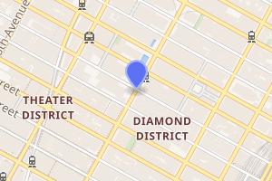
| Coordinates | 40.758603°N 73.981376°W | ||||||||||||
| Division | B (IND) | ||||||||||||
| Line | IND Sixth Avenue Line | ||||||||||||
| Services | B D F M | ||||||||||||
| Transit connections | |||||||||||||
| Structure | Underground | ||||||||||||
| Platforms | 2 island platforms cross-platform interchange | ||||||||||||
| Tracks | 4 | ||||||||||||
| Other information | |||||||||||||
| Opened | December 15, 1940 | ||||||||||||
| Station code | 225[1] | ||||||||||||
| Accessible | |||||||||||||
| Wireless service | |||||||||||||
| Opposite-direction transfer available | Yes | ||||||||||||
| Traffic | |||||||||||||
| Passengers (2019) | 18,604,810[3] | ||||||||||||
| Rank | 11 out of 424[3] | ||||||||||||
| Station succession | |||||||||||||
| Next north | 57th Street (63rd Street): F and <F> Seventh Avenue (Eighth Avenue): B Fifth Avenue/53rd Street (Queens Boulevard): M | ||||||||||||
| Next | Lexington Avenue–63rd Street (63rd Street): F and <F> 59th Street–Columbus Circle (Eighth Avenue): B Lexington Avenue–53rd Street (Queens Boulevard): M | ||||||||||||
| Next south | 42nd Street–Bryant Park: B | ||||||||||||
| Next | 34th Street–Herald Square: B | ||||||||||||
| |||||||||||||
| |||||||||||||
| |||||||||||||
History
47th–50th Streets–Rockefeller Center opened in 1940 as part of the mainline portion of the IND Sixth Avenue Line to West Fourth Street–Washington Square, with connections to the IND Queens Boulevard Line to the north.[4] Rockefeller Center's underground mall, built in 1935 as part of the complex's construction,[5] contains passageways to the station.[6]
Express service began in 1967 with the completion of express tracks between West Fourth and 34th Streets and the opening of the Chrystie Street Connection.[7][8]
Station layout
| G | Street level | Exit/entrance |
| M | Mezzanine | Fare control, station agent, Rockefeller Center concourse |
| P Platform level |
Northbound local | ← ← |
| Island platform | ||
| Northbound express | ← ← | |
| Southbound local | | |
| Island platform | ||
| Southbound express | | |
The station has two island platforms and four tracks, like most express stations, but has an unusual track arrangement. The uptown side has the traditional arrangement of local service on the outside track and express service on the inside track, but the downtown side reverses this (local on the inside, express on the outside). This is to avoid level junctions with the IND Queens Boulevard Line, which is perpendicular with the IND Sixth Avenue Line north of this station. Express trains come from the Bronx via a connection from the IND Eighth Avenue Line while local trains come from Queens via either the IND 63rd Street Line or the 53rd Street Tunnels. South of this station, the downtown local track crosses under the express track and the line returns to the traditional arrangement in both directions at 42nd Street–Bryant Park.[9]
Each platform has seven stairs to mezzanine, the north end of the northbound platform has an active tower, and is depressed about ten feet below the southbound platform. This is to prepare the lines to be branched out towards the Bronx and Queens. The color band is Permanent Red, with Chocolate Brown borders, "47" and "50" alternate each other below the tile band. The tiles above and below it are white. Also at this station, there is a sign next to the tower saying "What you punch is what you get"; this sign is referring to the automatic punch boxes on both tracks on the northbound platform. In the case of an emergency or service reroute, the express tracks can also be used to access the 63rd Street tunnel.
Exits

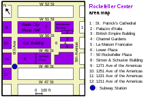
The station has numerous passageways and exits, including fourteen street stairs and an elevator. This does not include several passageways through Rockefeller Center, all of which are outside fare control. The mezzanine has a full-time booth at its north end, at West 49th Street. A passageway to one northern part-time staircase leads to West 50th Street. Another passageway along the west side of 49th Street connects to the 49th Street subway station on the BMT Broadway Line outside of fare control. The middle fare control at West 48th Street has a ghost booth and all-day HEET access. The south fare control at West 47th Street has a part-time booth and more staircases.[10]
- One stair, on street, to NW corner of 6th Avenue and 50th Street[10]
- One stair, within Radio City Music Hall building, to east side of 6th Avenue north of 50th Street;[10] usually open late during evening performances
- One stair, within plaza of 1251 Avenue of the Americas (facing street), to SW corner of 6th Avenue and 50th Street[10]
- Passageway directly to 1251 Avenue of the Americas[10]
- Passageway directly to 30 Rockefeller Plaza[10]

- One stair, within 30 Rockefeller Plaza, to NE corner of 6th Avenue and 49th Street[10]
- Two stairs, within courtyard of 1221 Avenue of the Americas (under grade level), to west side of 6th Avenue between 48th and 49th Streets[10]
- One stair, within Simon & Schuster Building (1230 Avenue of the Americas), to west side of 6th Avenue between 48th and 49th Streets[10]
- Passageway directly to Simon & Schuster Building[10]
- One stair, on street, to NE corner of 6th Avenue and 48th Street[10]
- One stair, on street, to SE corner of 6th Avenue and 48th Street[10]
- One stair, within plaza of 1211 Avenue of the Americas (facing street), to SW corner of 6th Avenue and 48th Street[10]
- Passageway directly to 1211 Avenue of the Americas[10]
- One stair, on street, to NE corner of 6th Avenue and 47th Street[10]
- One stair, on street, to SE corner of 6th Avenue and 47th Street[10]
- One stair, on street, to SW corner of 6th Avenue and 47th Street[10]
In popular culture
The station was featured in the 1976 film Marathon Man, where the former KK route's emblem is posted on a street entrance of the east side of Sixth Avenue and West 47th Street.
The station exit to 1271 Avenue of the Americas (Time and Life Building) was featured in the opening sequence of 2012 film The Secret Life of Walter Mitty.
References
- "Station Developers' Information". Metropolitan Transportation Authority. Retrieved June 13, 2017.
- "NYC Subway Wireless – Active Stations". Transit Wireless Wifi. Retrieved November 13, 2019.
- "Facts and Figures: Annual Subway Ridership 2014–2019". Metropolitan Transportation Authority. 2020. Retrieved May 26, 2020.
- "New Subway Line on 6th Ave. Opens at Midnight Fete". The New York Times. December 15, 1940. p. 1. Retrieved October 7, 2011.
- "ROCKEFELLER CITY FINISHES TUNNELS" (PDF). The New York Times. May 4, 1935. ISSN 0362-4331. Retrieved November 11, 2017.
- Jackson, Kenneth T., ed. (2010). The Encyclopedia of New York City (2nd ed.). New Haven: Yale University Press. p. 1115. ISBN 978-0-300-11465-2.
- Perlmutter, Emanuel (November 16, 1967). "SUBWAY CHANGES TO SPEED SERVICE: Major Alterations in Maps, Routes and Signs Will Take Effect Nov. 26" (PDF). nytimes.com. The New York Times. Retrieved July 7, 2015.
- Perlmutter, Emanuel (November 27, 1967). "BMT-IND CHANGES BEWILDER MANY; Transit Authority Swamped With Calls From Riders as New System Starts". The New York Times. Retrieved August 23, 2015.
- "www.nycsubway.org: New York City Subway Track Maps". www.nycsubway.org. October 9, 2015. Retrieved October 9, 2015.
- "MTA Neighborhood Maps: Midtown West" (PDF). mta.info. Metropolitan Transportation Authority. 2015. Retrieved December 11, 2015.
External links
| Wikimedia Commons has media related to 47th–50th Streets – Rockefeller Center (IND Sixth Avenue Line). |
- nycsubway.org – IND Sixth Avenue Line: 47th–50th Streets/Rockefeller Center
- Station Reporter — B Train
- 50th Street entrance from Google Maps Street View
- 49th Street entrance from Google Maps Street View
- 48th Street entrance from Google Maps Street View
- 47th Street entrance from Google Maps Street View
- Platforms from Google Maps Street View
- Mezzanine from Google Maps Street View


