79th Street station (BMT West End Line)
79th Street is a local station on the BMT West End Line of the New York City Subway, located at the intersection of 79th Street and New Utrecht Avenue in Bensonhurst, Brooklyn. It is served by the D train at all times.
79 Street | |||||||
|---|---|---|---|---|---|---|---|
 | |||||||
| Station statistics | |||||||
| Address | 79th Street & New Utrecht Avenue Brooklyn, NY 11214 | ||||||
| Borough | Brooklyn | ||||||
| Locale | Bensonhurst | ||||||
| Coordinates | 40.61339°N 74.001514°W | ||||||
| Division | B (BMT) | ||||||
| Line | BMT West End Line | ||||||
| Services | D | ||||||
| Structure | Elevated | ||||||
| Platforms | 2 side platforms | ||||||
| Tracks | 3 (2 in regular service) | ||||||
| Other information | |||||||
| Opened | June 24, 1916 | ||||||
| Station code | 065[1] | ||||||
| Opposite-direction transfer available | Yes | ||||||
| Traffic | |||||||
| Passengers (2019) | 1,926,290[2] | ||||||
| Rank | 247 out of 424[2] | ||||||
| Station succession | |||||||
| Next north | 71st Street: D | ||||||
| Next south | 18th Avenue: D | ||||||
| |||||||
| |||||||
| |||||||

%26groups%3D_6e63e32966b6c052dbcca1fbaef332e008debc89.svg)
History
79th Street station opened on June 24, 1916 along with the first portion of the BMT West End Line from 36th Street on the BMT Fourth Avenue Line to 18th Avenue station.[3][4] The line was originally a surface excursion railway to Coney Island, called the Brooklyn, Bath and Coney Island Railroad, which was established in 1862, but did not reach Coney Island until 1864.[5] Under the Dual Contracts of 1913, an elevated line was built over New Utrecht Avenue, 86th Street and Stillwell Avenue. The section of the West End Line between 62nd Street and 18th Avenue originally opened with only one track in service. The second track between 62nd Street and 18th Avenue opened on July 8, 1916.[6]
The platforms were extended in the 1950s to accommodate the current standard B Division train length of 615 feet (187 m).
In 2012, the station was rehabilitated with funding from the American Recovery and Reinvestment Act of 2009.[7]
Station layout
| P Platform level |
Side platform | |
| Northbound local | ← | |
| Peak-direction express | No regular service | |
| Southbound local | | |
| Side platform | ||
| M | Mezzanine | Fare control, station agent, MetroCard machines |
| G | Street level | Entrance/exit |
.JPG)
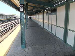
This elevated station, opened on September 15, 1916, has three tracks and two side platforms. The center express track is not normally used. The Manhattan-bound platform has a full beige windscreen and brown canopies with green frames and support columns in the center. The Coney Island-bound platform has a beige windscreen and brown canopies with green frames and support columns in the center and high mesh fences at either ends. The station signs are in the standard black plates with white lettering.
Exits
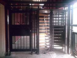
The station has two fare control areas, both of which are elevated station houses beneath the platforms and tracks. The full-time one is at the south end. A single staircase from each platform go down to a waiting area/crossunder, where a turnstile bank provides access to/from the system. Outside fare control, there is a token booth and two staircases going down to either northern corners of New Utrecht Avenue and 79th Street.[8]
The station's other fare control area towards the north end is un-staffed. A single staircase from each platform goes down to a landing around a now-closed station house. A single full height turnstile provides access to/from the station before another staircase goes down to either southern corners of New Utrecht Avenue and 77th Street.[8]
References
- "Station Developers' Information". Metropolitan Transportation Authority. Retrieved June 13, 2017.
- "Facts and Figures: Annual Subway Ridership 2014–2019". Metropolitan Transportation Authority. 2020. Retrieved May 26, 2020.
- "Parade, Pageant Mark Celebration". The Brooklyn Daily Eagle. June 24, 1916. p. 8. Retrieved September 16, 2015.
- "Realty Boom Is Predicted for Borough Park Section". The Brooklyn Daily Eagle. June 24, 1916. p. 8. Retrieved September 16, 2015.
- "Opening of the Brooklyn, Bath and Coney Island Railroad" (PDF). The New York Times. June 9, 1864. p. 2. Retrieved July 28, 2020.
- Senate, New York (State) Legislature (January 1, 1917). Documents of the Senate of the State of New York.
- Nunez, Jenifer (August 3, 2012). "MTA completes seven station rehabilitation projects along D Line". Railway Track & Structures. Archived from the original on 2020-07-28. Retrieved August 6, 2012.
- "MTA Neighborhood Maps: Bensonhurst" (PDF). mta.info. Metropolitan Transportation Authority. 2015. Retrieved August 15, 2016.
External links
| Wikimedia Commons has media related to 79th Street (BMT West End Line). |
- nycsubway.org – BMT West End Line: 79th Street
- Station Reporter — D Train
- 79th Street entrance from Google Maps Street View
- 77th Street entrance from Google Maps Street View
- Platforms from Google Maps Street View
| West End Line |
|
|---|---|
| |