Mount Pleasant (Washington, D.C.)
Mount Pleasant is a neighborhood in the northwestern quadrant of Washington, D.C., the capital of the United States. The neighborhood is bounded by Rock Creek Park to the north and west; and Harvard Street, NW, and the Adams Morgan neighborhood to the south; and Sixteenth Street, NW, and the Columbia Heights neighborhood to the east. The neighborhood is home to about 10,000 people.
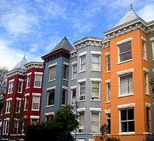
Mount Pleasant Historic District | |
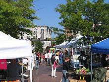
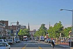 Mount Pleasant Street NW, the commercial corridor of the Mount Pleasant neighborhood | |
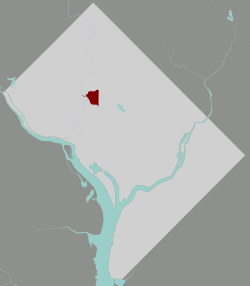 Map of Washington, D.C., with Mount Pleasant highlighted in maroon. | |
| Location | Roughly bounded by 16th Street, Harvard Street, Adams Mill Road, and Rock Creek Park, Washington, D.C. |
|---|---|
| Coordinates | 38°55′43.3″N 77°2′14.4″W |
| NRHP reference No. | 87001726[1] |
| Added to NRHP | October 5, 1987 |
History
In 1727, Charles Calvert, 5th Lord Baltimore (then governor of the Maryland Colony) awarded a land grant for present-day Mount Pleasant to James Holmead. This estate included the territory of present-day Adams Morgan, Columbia Heights, and Pleasant Plains neighborhoods. James's son, Anthony, inherited the estate in 1750 and named it Pleasant Plains. After the United States Congress created the District of Columbia in 1791, Pleasant Plains estate became part of Washington County, a section of the District lying between what now is Florida Avenue and the Maryland border. The Holmeads gradually sold off all tracts of the Pleasant Plains estate. In the 21st century, the family name is preserved in Holmead Place, a short street located west of Thirteenth Street between Spring and Park Roads NW, in what now is Columbia Heights. During 1794 and 1796, Robert Peter, Georgetown's pioneer businessman, conducted title descriptions. He created maps for tracts of some of his land in Mount Pleasant for transactions with commissioners of the city.[2]
In 1861, William Selden—a former treasurer of the United States—owned 73 acres (300,000 m2) of land north of Pierce Mill Road. In 1862, during the Civil War, Selden, a Confederate sympathizer, was forced to sell his land at a low price and move back to his native Virginia. The purchaser was New England native Samuel P. Brown.[3] Brown built a house and allowed a wartime hospital to be constructed on his land. After the War, he began selling his land in parcels. He named the area Mount Pleasant Village because it contained the land having the highest elevation of the original Pleasant Plains estate. Brown sold all his land except for the parcel he retained around his house at 3351 Mount Pleasant Street, NW.[4] His house was demolished in the 1890s.
Most of the original settlers built wooden frame houses and farmed their tracts, growing their own food. Stores and other businesses opened around what today is the intersection of Fourteenth Street and Park Road, NW. Settlers laid out early roads in the area, such as Adams Mill Road, Mount Pleasant Street, Newton Street, and Park Road to follow local custom and to accommodate local needs and land ownership. Although Mount Pleasant was within the District of Columbia, it was separated from the city of Washington by vacant land and was rural by comparison. Because of this separate development, the Mount Pleasant street grid is distinct from Washington's rectilinear grid. Now that the two are part of a single urban fabric, some of its streets appear to have been laid out haphazardly, with several intersecting city streets at odd or severe angles to the greater design.
In the 1870s, a horse-drawn streetcar began traveling between the Fourteenth and Park intersection to downtown Washington city, making this the first streetcar suburb in the District of Columbia. Mount Pleasant ceased to be an independent and separate place in 1878 after the city's boundaries became coterminous with those of the District. Mount Pleasant developed rapidly as a streetcar suburb after the opening of the mechanized streetcar line around 1900. In 1907, developer Fulton R. Gordon purchased large sections of the neighborhood, marketing lots as "Mount Pleasant Heights" with Robert E. Heater.[5] Many houses and apartment buildings were constructed between 1900 and 1925. In 1925, the District built the Mount Pleasant Library, partially funded by philanthropist Andrew Carnegie, to serve the growing and affluent community.
The streets were lined with tall trees that created a continuous canopy of shade. Gardens of ivy, shrubs, and flowering plants were created in the successive terraces from the streets to the base of the stairs of the typical front porches. Landings in the staircases through the terraces were marked with fountains and sculpture. Houses were built next to each other as row houses. Alleys between all streets provided access for servants and services. Fences separated properties into back yards planted with vegetable gardens and fruit trees, and sites for barns and garages. Many houses were constructed with two levels of cellars below the entry level from the main street, but all having disguised access for landscape equipment through the cellars under the house. Rear sleeping porches extended from the floors with bedrooms.
Mount Pleasant was marketed to middle- to upper middle-class people. Actress Helen Hayes, Washington Senators pitcher Walter Johnson, and U.S. Senator Robert M. La Follette Sr. made their homes in Mount Pleasant.
The neighborhood entered a period of transition in the 1960s. Mount Pleasant was racially segregated, as were most neighborhoods of Washington, D.C., at the time. This changed after passage of the Civil Rights Act of 1964, although some neighborhoods remained de facto segregated. After an African American Howard University professor moved into a prestigious Park Road home, some white residents began to leave the neighborhood. This form of suburbanization, often referred to as White flight, increased after the 1968 riots, which caused widespread destruction along the commercial U Street NW corridor and other areas of the city. Gradually, as lower-income residents moved in and rented portions of rowhouses divided for multiple occupancy, some properties suffered neglect. Most of the characteristic landscaping was lost, with the exception of the canopy of shade trees. Many of Mount Pleasant's streets continue to be shaded by oak and elm trees over 100 years old.
As African Americans began to settle in Mount Pleasant, a new wave of immigrants from Central America came to the capital. Spanish-speaking immigrants began settling in Mount Pleasant in the 1960s, many from El Salvador and the Dominican Republic. Adams Morgan to the west already had a large Latino population in its ethnic mix, and they had developed businesses along Columbia Road and 18th Street that new immigrants found familiar. The new residents also developed businesses catering to Hispanics and Latinos along commercial portions of Mount Pleasant Street. The neighborhood also attracted former Peace Corps workers, who liked the diversity. Commercially developed Columbia Road extended from the Adams Morgan neighborhood to 16th Street. Businesses included grocery store and pharmacy, restaurants, low-priced retail stores and services.
Affluent professionals began returning to the neighborhood in the early 1980s. According to the Washingtonian magazine, housing prices rose nearly as fast as in any area of metropolitan Washington. The new residents renovated many homes, and some projects were featured in local and national magazines. A $1 million "green" renovation was featured in a National Public Radio story. The neighborhood was majority-minority in 1990, with African Americans making up 36% of the population, Latinos 26%, and whites 35%. More recent Asian immigrants also settled there. The students at the neighborhood public schools were primarily minority children.
1991 racial rioting
In May 1991, a black woman police officer shot a Latino man, leading to a multi-day riot. Two days of fighting erupted between the Salvadoran Latinos and blacks in the neighborhood, accompanied by looting, arson and attacks on the police. Property damage was in the millions, and 19 police cars were destroyed; twelve people were injured but no one was killed.[6] In response, the Metropolitan Police Department, under Chief Isaac Fulwood, and city government began an outreach effort to the Latino population.[7]
After 1991, demographics of the neighborhood changed markedly. As housing prices have gone up, given the strong economy of the District and many educated residents with high-paying jobs, some Latino immigrants and their descendants have moved to more affordable D.C. neighborhoods east of Mount Pleasant, as well as to more distant suburbs. African Americans have also left the neighborhood, to an even greater extent: some have moved to the South, in what the Brookings Institution defines as a New Great Migration,[8] and some have moved to eastern neighborhoods in the District or to suburbs. According to the 2010 census, African Americans compose 19% of the population, the smallest of the three main ethnicities in the neighborhood. Their proportion of the population in the District overall has dropped during these two decades.
Western areas
The western four-fifths of the Mount Pleasant area is a largely wooded residential enclave bounded on two sides by Rock Creek Park. Structures in this area are primarily row houses, with some subdivided into one or two apartments. A few of the original 19th-century wood-frame houses remain, mostly north of Park Road. The eastern border of Mount Pleasant, along Sixteenth and Mount Pleasant Streets, is marked by mid-rise apartment buildings. These buildings offer rental apartments, condominiums and cooperatives. A four-block commercial corridor with convenience shopping in the neighborhood extends along Mount Pleasant Street. In 2008, a large retail development was completed in Columbia Heights, the neighborhood just east of Mount Pleasant.
Population
The population of Mount Pleasant, according to the 2010 census, was 10,459, down from 11,794 in 2000. Census data for 1990, 2000, and 2010 show the demographic changes underway in Mount Pleasant:[9]
| 1990 | 2000 | 2010 | |
|---|---|---|---|
| white non-Hispanic | 35% | 35% | 50% |
| black non-Hispanic | 36% | 27% | 26% |
| Hispanic | 26% | 31% | 25% |
| Asian/Pacific Islander | 3.0% | 6.3% | 5.6% |
Also evident is the transition of this neighborhood from one of modest to fairly high incomes, an example of gentrification.
| 1979 | 1989 | 1999 | 2010 | |
|---|---|---|---|---|
| Average family income (2010 $) | $75,980 | $77,704 | $90,838 | $130,790 |
| Ratio to DC average | 98% | 83% | 89% | 114% |
Education
- District of Columbia Public Schools operates public schools.
- Bancroft Elementary School
- Private Religious Schools.
- Sacred Heart School
- District of Columbia Public Library operates the Mount Pleasant Neighborhood Library.[10][11]
Heritage Trail
A series of "Heritage Trail" historical markers have been installed in Mt. Pleasant. The markers, which may be followed as a walking tour, consist of 17 poster-sized street signs featuring narrative, photographs and maps.[12]
Markers
The markers are captioned as follows, at these locations:
- Fashionable 16th Street (16th and Mt. Pleasant Streets, NW)
- Upheaval and Activism (16th Street between Irving and Lamont Streets, NW)
- Mount Pleasant Library (16th and Lamont Streets, NW)
- Sacred Heart Academy (16th Street and Park Road, NW)
- Avenue of Churches (16th and Newton Streets, NW)
- Village Life (17th Street and Oakwood Terrace, NW)
- Twenty-seven Little Flags (Newton and 18th Streets, NW)
- The Oldest House (Newton Street between 18th and 19th streets, NW)
- Czech Row (Park and Klingle Roads, NW)
- Voices at Vespers (Rosemount Avenue and Klingle Road, NW)
- Defying the Restrictive Covenants (Park Road between 18th and 19th streets, NW)
- Changing Fashions (18th Street and Park Road, NW)
- War and Peace (Triangle Park Park Road and Mt. Pleasant street, NW)
- Main Street (North end of Lamont Park, NW)
- Streetcar Suburb (Lamont and Mt. Pleasant Streets, NW)
- The First Bodega (Mt. Pleasant Street at Kilbourne Place, NW)
- The Urban Village (Mt. Pleasant and Kenyon Streets, NW)
References
- "National Register Information System". National Register of Historic Places. National Park Service. March 13, 2009.
- Iris Miller, Washington in Maps 1606–2000, pages 62–63 with illustrations of the Squares Number 37 and Number 70, Rizzoli International Publications, Inc., New York, 2002, ISBN 0-8478-2447-0
- Mount Pleasant Historical District brochure - PDF
- Cultural Tourism DC Archived 2007-06-30 at the Wayback Machine
- "FULTON R. GORDON AND ROBERT E. HEATER ARE Extending and Beautifying the Nation's Capital.: Virginians Make a Specialty of Opening New Northwest Suburban Property". The Washington Post. 24 February 1907.
- David Waddington, Contemporary Issues in Public Disorder: A Comparative and Historical Approach (1992) p 71 online
- Hermann, Peter (2017-09-01). "Isaac Fulwood, Washington police chief during tumultuous era, dies at 77". Washington Post. Retrieved 2017-09-30.
- William H. Frey, "The New Great Migration: Black Americans' Return to the South, 1965-to the present" Archived 2004-07-02 at the Wayback Machine, The Brookings Institution, accessed 19 Mar 2008
- http://www.neighborhoodinfodc.org/anc/nbr_prof_anc4.html
- "Hours & Locations." District of Columbia Public Library. Retrieved on October 21, 2009.
- "Mount Pleasant Branch Library Archived 2009-02-14 at the Wayback Machine"
- "Village in the City: Mount Pleasant Heritage Trail". Cultural Tourism DC. Retrieved September 9, 2014.
External links
| Wikimedia Commons has media related to Mount Pleasant, Washington, D.C.. |
- ANC1D, The Mount Pleasant Advisory Neighborhood Commission
- Friends of the Mount Pleasant Library
- Historic Mount Pleasant
- Mount Pleasant Main Street, Inc.
- Mount Pleasant Neighborhood Guide
- Why Is It Named Mt. Pleasant? - Ghosts of DC blog
Places adjacent to Mount Pleasant (Washington, D.C.) | ||||||||||
|---|---|---|---|---|---|---|---|---|---|---|
| ||||||||||