Randle Highlands
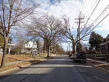
Randle Highlands is a neighborhood in Southeast Washington, D.C., east of the Anacostia River.
History
Born in 1859, Colonel Arthur E. Randle was a late nineteenth and early twentieth-century real estate developer, who earned some recognition for building Congress Heights, before developing Hillcrest and other neighborhoods, east of the Anacostia River.[1] Moving his family into a large, Greek Revival house - later nicknamed 'The Southeast White House' - in what is, now, the Randle Highlands neighborhood, Randle encouraged more Washingtonians to follow and build grand homes, along Pennsylvania Avenue.[2]
Transportation
The nearest Metrorail station to Randle Highlands is the Potomac Avenue Station, which is located on Pennsylvania Avenue about 1.5 miles west of Randle Highlands. Although the neighborhood is not directly served by a rail station, it is served by several Washington Metropolitan Area Transit Authority (WMATA) Metrobus lines, all of which stop at the Potomac Avenue Station.[3][4][5][6]
| Route | Name | Type | Western Terminus | Eastern Terminus | Randle Highlands Via | Eastbound Stops in Randle Highlands | Westbound Stops in Randle Highlands |
|---|---|---|---|---|---|---|---|
| 30N | Friendship Heights-Southeast Line | Local | Friendship Heights Station | Naylor Road Station | Pennsylvania Avenue | 27th Street, 30th Street, and 31st Street | 31st Street, 30th Street, and 28th Street |
| 30S | Friendship Heights-Southeast Line | Local | Friendship Heights Station | Southern Avenue Station | Naylor Road, 23rd & 25th Streets | Park Place, R Street, and S Street | S Street, R Street, and Q Street |
| 32 | Pennsylvania Avenue Line | Local | Potomac Park | Southern Avenue Station | Naylor Road, 23rd & 25th Streets | Park Place, R Street, and S Street | S Street, R Street, and Q Street |
| 34 | Pennsylvania Avenue Line | Local | Archives Station | Naylor Road Station | Naylor Road, 23rd & 25th Streets | Park Place, R Street, and S Street | S Street, R Street, and Q Street |
| 36 | Pennsylvania Avenue Line | Local | Potomac Park | Naylor Road Station | Pennsylvania Avenue | 27th Street, 30th Street, and 31st Street | 31st Street, 30th Street, and 28th Street |
| M6 | Fairfax Village Line | Local | Potomac Avenue Station | Fairfax Village | Pennsylvania Avenue | 27th Street, 30th Street, and 31st Street | 31st Street, 30th Street, and 28th Street |
| 39 | Pennsylvania Avenue MetroExtra Line | Limited Stop | Potomac Park | Naylor Road Station | Pennsylvania Avenue | 30th Street | 30th Street |
Education
Elementary school
Randle Highlands Elementary School (1650 30th Street, S.E.) is the only school located within the Randle Highlands neighborhood. Most elementary age students living in Randle Highlands live in the Randle Highlands Elementary School district, however, some elementary students in Randle Highlands live in the Lawrence E. Boone Elementary School (2200 Minnesota Avenue, S.E.) district. The original school was built in 1911, then replaced by a newer building in 2002.
Middle school
Most middle school aged students in Randle Highlands live in the Sousa Middle School (3650 Ely Place, S.E.) district, however, some middle school students in Randle Highlands live in the Kramer Middle School (1700 Q Street, S.E.) district.
High school
All of Randle Highlands is in the Anacostia High School (1601 16th Street, S.E.) school district.[7]
Government & politics
Federal
Randle Highlands is located entirely within the borders of the District of Columbia, which means they do not have voting representation in Congress. However, the residents of the District of Columbia elect a non-voting delegate to congress as well as two Shadow Senators and a Shadow Representative who promote the interests of residents.
Current representation at the federal level
| Name | Position | Party | Took office | Up for reelection |
|---|---|---|---|---|
| Eleanor Holmes Norton | Delegate | Democratic | 1991 | 2020 |
| Paul Strauss | Shadow Senator | Democratic | 1997 | 2020 |
| Michael Brown | Shadow Senator | Democratic | 2007 | 2024 |
| Franklin Garcia | Shadow Representative | Democratic | 2015 | 2020 |
District
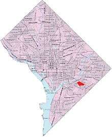
Randle Highlands is located primarily in Ward 7, although a small section of the westernmost portion of the neighborhood is located in Ward 8.
Current representation at the district level
| Name | Position | Party | Took office | Up for reelection |
|---|---|---|---|---|
| Phil Mendelson | Chairman | Democratic | 1999 | 2022 |
| David Grosso | At-large | Independent | 2013 | 2020 |
| Elissa Silverman | At-large | Independent | 2015 | 2022 |
| Anita Bonds | At-large | Democratic | 2012 | 2022 |
| Robert White | At-large | Democratic | 2016 | 2020 |
| Vince Gray | Ward 7 | Democratic | 2017 | 2020 |
| Trayon White | Ward 8 | Democratic | 2017 | 2020 |
Local
In addition to the eight wards, the District of Columbia is further divided into Advisory Neighborhood Commission's or ANC's which are a non-partisan, neighborhood body made up of locally elected commissioners elected to two year terms from their ANC's single member district (SMD). While Randle Highland is primary in SMD 7B02,[9] there is a small section of the neighborhood in SMD 7B03[9] as well as a small section in SMD 8A01.[10]
Current representation at the local level
| Name | Single Member District | Party |
|---|---|---|
| Tiffany L. Brown | 7B02[11] | Non-Partisan |
| Benjamin Crane | 7B03[11] | Non-Partisan |
| Nicole Smith-McDermott | 7B04[11] | Non-Partisan |
| Holly Muhammad | 8A01[12] | Non-Partisan |
| Troy Prestwood | 8A03[12] | Non-Partisan |
Civic association
Randle Highlands has an active civic association which meets during the months of March through November on the 4th Thursday of each month at the D.C. Dream Center (2826 Q Street, S.E.).[13]
Boundaries
Randle Highlands is bounded by Pennsylvania Avenue SE to the north; Naylor Road, 27th Street, and Texas Avenue to the south; Fort Stanton Park to the southeast; and Minnesota Avenue to the west.
Bordering neighborhoods
Places adjacent to Randle Highlands | ||||||||||
|---|---|---|---|---|---|---|---|---|---|---|
| ||||||||||
References
- "Randle, Col. Arthur E. (obituary)" (PDF). Washington Post. July 5, 1929. p. 3.
- "Reminiscences by Ulmo E. Randle". History - Southeast White House. Archived from the original on April 2, 2015. Retrieved March 14, 2015.
- "Metrobus 30N & 30S Map" (PDF). Washington Metropolitan Area Transit Authority. Retrieved 24 August 2016.
- "Metrobus Routes 32, 34, & 36 Map" (PDF). Washington Metropolitan Area Transit Authority. Retrieved 24 August 2016.
- "Metrobus Route M6 Map" (PDF). Washington Metropolitan Area Transit Authority. Retrieved 24 August 2016.
- "Metrobus Route 39 Map" (PDF). Washington Metropolitan Area Transit Authority. Retrieved 24 August 2016.
- "SY2016-2017 School Feeder Patterns" (PDF). District of Columbia Public Schools.
- "D.C. Councilmembers". Council of the District of Columbia. Retrieved 24 August 2016.
- "ANC7B 2013 Boundaries" (PDF). 2013 ANC and SMD Boundaries. Retrieved 24 August 2016.
- "ANC 8A 2013 Boundaries" (PDF). 2013 ANC and SMD Boundaries.
- "Advisory Neighborhood Commission 7B". District of Columbia Advisory Neighborhood Commissions. Retrieved 24 August 2016.
- "2015-2016 Commissioners". Advisory Neighborhood Commission 8A. Retrieved 24 August 2016.
- "Randle Highlands Civic Association Community Meeting". Randle Highlands Civic Association Meetings.