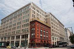
Downtown (Washington, D.C.)
Downtown is a neighborhood of Washington, D.C., as well as a colloquial name for the central business district in the northwest quadrant of the city. Geographically, the area encompassed varies according to the source. Some consider Downtown to be the Penn Quarter area east of the White House, while others consider it to be the Golden Triangle area northwest of the White House, and others consider Downtown to consist of both areas. Several important museums, theaters, and a major sports venue are located in the area. A portion of this area is known as the Downtown Historic District and was listed on the NRHP in 2001.[1]
Downtown Historic District | |
 | |
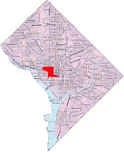 Map of Washington, D.C., with downtown Washington highlighted in red | |
| Location | Roughly, 7th St. from Pennsylvania Ave. to Mt. Vernon Sq., and F St. between 11th and 7th Sts., NW, Washington, D.C. |
|---|---|
| Area | 50 acres (20 ha) |
| Architect | Multiple |
| Architectural style | Late 19th And 20th Century Revivals, Late Victorian |
| NRHP reference No. | 84003901[1] |
| Added to NRHP | September 22, 2001 |
Geography and subdistricts

There are no neighborhoods or neighborhood boundaries that the D.C. Government officially defines,[2] so there are varying definitions of which areas constitute Downtown D.C. or the central business district of D.C.
The Washington Post in 2014 referred to "downtown" as the areas covered by two business improvement districts (BIDs):
- DowntownDC (the historic central business east of the White House) and
- Golden Triangle (areas which have more recently been regarded as part of the CBD, west of the White House).[3]
Together, they form a diamond-shaped area stretching from Union Station, south to the National Mall, northwest past the White House to Washington Circle in Foggy Bottom and northeast to DuPont Circle.
Downtown business improvement district
The Downtown BID boundaries roughly conform with the more traditional definitions of Downtown and those of the Downtown Urban Renewal Action Area[4] and are:[5]
- North-northeast: Massachusetts Avenue, N.W. and the Mount Vernon Triangle, Mount Vernon Square, Shaw, and Logan Circle neighborhoods,
- East: North Capitol Street, N.W. and Louisiana Avenue, N.W. (roughly Union Station), and the Capitol Hill neighborhood,
- South: east of 6th Street, N.W., by Constitution Avenue, N.W. and the National Mall, and west of 6th Street, N.W., by Pennsylvania Avenue, N.W. and Federal Triangle
- West: 15th and 16th streets, N.W. (roughly, the White House grounds) – to the west of the White House is the Golden Triangle BID –
The Downtown BID thus encompasses Penn Quarter, Chinatown and the F Street shopping district.
Golden Triangle business improvement district
The Golden Triangle BID boundaries are, very roughly:[6]
- Northwest: New Hampshire Ave., N.W., and the DuPont Circle neighborhood,
- Northeast: Massachusetts Ave., N.W., and the DuPont Circle neighborhood,
- East: 16th Street, N.W. and the DowntownDC BID,
- Southwest: Pennsylvania Avenue, N.W. and the Foggy Bottom neighborhood,
- West: 21st Street, N.W., and the Foggy Bottom and the West End neighborhoods.
The Golden Triangle BID thus overlaps a southern portion of the DuPont Circle neighborhood.
The Washington, D.C. tourist office promotes the Golden Triangle area as "Downtown" and the area to its east more traditionally known as Downtown, as "Penn Quarter & Chinatown".[7]
Character, attractions, and services
By the 1990s and continuing into the 2010s, the core of the downtown district was almost exclusively commercial, and its primary commercial use was as office buildings.[8] The area also featured a number of attractions, including museums (such as the International Spy Museum, National Aquarium, National Archives, National Building Museum, National Museum of Women in the Arts, National Portrait Gallery, Newseum, and Smithsonian American Art Museum) and theaters (such as Ford's Theatre, National Theatre, Shakespeare Theatre, Warner Theatre, and Woolly Mammoth Theatre).[9] The Penn Quarter and Chinatown areas in particular are home to many bars and restaurants,[10] and the observation deck in the tower of the Old Post Office Pavilion is known for its views of the city.[11] 7th Street NW between H and F Streets NW—a short commercial strip known as "Gallery Place"—has become a major hub of bars, restaurants, theaters, and upscale retail shops.[12]
However, even as late as 2010, most of the core area tended to be empty of pedestrian foot traffic at night, except for streets immediately around theaters and restaurants.[8][13] Downtown D.C. has been adding residents, however, and pedestrian traffic at night is increasing. In 1990, the area had about 4,000 residents, but this had increased to 8,449 by 2010.[14] Such increases appear small, but are more significant than they seem because the city's height restrictions limit population density.[15] The completion of the $950 million CityCenterDC project in late 2013 is estimated to add another 1,000 or more residents.[14] One exception to the low nighttime foot traffic is Gallery Place. Large crowds gather day and night at Gallery Place, especially after sporting events at the Capital One Arena.[12] Crime and street brawls in the area skyrocketed in the area and its adjacent Gallery Place Metro station between 2008 and 2010, primarily due to the large groups of teenagers (from throughout the metropolitan region) gathering there.[12]
Several notable restaurants exist in the downtown district, including Fogo de Chão, Kinkead's, Loeb's NY Deli, Old Ebbitt Grill, and Wok 'n' Roll (located in the Mary E. Surratt Boarding House). Chinatown and Gallery Place are noted for being geographically small but also having a very large number of restaurants.[10]
Capital One Arena (originally named the MCI Center and later changed to the Verizon Center), a major basketball, hockey, and events venue, opened in the Chinatown neighborhood on the eastern edge of the downtown district in 1997.[16] It proved to be a major attraction, drawing more than 20 million visitors in its first decade of operation.[16]
Cityscape
The majority of downtown Washington is composed of office buildings of varying architectural styles. The oldest tend to be of the Federal school, as are the White House, the Treasury Building, Blair House, and the rowhouses that line Lafayette Square. Others run the gamut from Neoclassical (such as the buildings at Federal Triangle)[17] to Second Empire-style (the Eisenhower Executive Office Building)[18] to postmodern (One Farragut Square South[19] and Franklin Tower at 1401 I Street NW).[20]
Height restriction
Unlike other large cities in the U.S., Washington's downtown has a low skyline. With the advent of the skyscraper and the construction of the Cairo Hotel, residents were concerned that the city's European feel might be dwarfed by high-rise buildings. Congress therefore passed the Heights of Buildings Act in 1899, limiting any new building in Washington to a height of 110 feet (34 m). The act was amended in 1910 to allow buildings 20 feet (6.1 m) higher than the width of the adjacent street.[21]
As of 2006, the tallest building in downtown Washington—excluding the Washington Monument, U.S. Capitol, Washington National Cathedral, and the Basilica of the National Shrine of the Immaculate Conception, all of which are outside of the downtown district—is the Old Post Office Pavilion, whose 315-foot (96 m) tall clock tower looms far above other nearby structures.[22] The tallest commercial building is One Franklin Square, at 210 feet (64 m).[23]
Parks and public squares
A number of public urban parks exist in the downtown area. Among the more prominent are: Farragut Square, Franklin Square, Judiciary Square, Lafayette Square (the portion of President's Park north of the White House), McPherson Square, Mount Vernon Square, Pershing Park, Scott Circle, Thomas Circle, and Washington Circle.
The largest paved square in the city, Freedom Plaza, is located on Pennsylvania Avenue NW between 13th and 14th Streets NW.
Governance
Two business improvement districts cover the downtown D.C. area. The Downtown DC Business Improvement District (Downtown DC BID) is bounded by 16th Street NW, Massachusetts Avenue NW, and Constitution Avenue NW, and is funded by a voluntary tax provided by 825 businesses in the area.[24] The Golden Triangle Business Improvement District (Golden Triangle BID) is bounded by 16th Street NW, Massachusetts Avenue NW, 21st Street NW, and Pennsylvania Avenue NW.[24] Both BIDs work to enhance the diversity of business in their respective jurisdictions as well as the quality of life by providing directions for tourists, improving street and sidewalk cleanliness, and advising police about potential or existing problems.
Various federal (Federal Protective Service, Federal Bureau of Investigation, Secret Service, United States Mint Police, United States Park Police, etc.), city (Metropolitan Police Department of the District of Columbia, District of Columbia Housing Authority Office of Public Safety), and regional (Metro Transit Police Department) law enforcement agencies have concurrent, overlapping jurisdiction in downtown D.C.[25] Both BIDs in the area also provide semi-uniformed unsworn police forces, which help to maintain order and provide street intelligence by communicating via cell phone with the Metropolitan Police Department and Metro Transit Police.[26] D.C. Housing Authority Police do not have jurisdiction outside public housing, but do patrol Gallery Place to pick up and provide intelligence on the activities of youth congregating there who live in city-provided housing units.[12]
Education
Higher Education
References
- "National Register Information System". National Register of Historic Places. National Park Service. July 9, 2010.
- "Neighborhood Clusters, OpenData DC, District of Columbia Government, accessed July 2, 2020
- DeBonis, Mike (April 25, 2014). "Twenty years of downtown D.C. development in one GIF". Washington Post.
- Map of Downtown Urban Renewal Action Area, National Capital Planning Commission site, accessed July 2, 2020
- "BID Map", DowntownDC business improvement district official website, accessed July 2, 2020
- Map of Golden Triangle DC from Golden Triangle BID, accessed July 2, 2020
- "Penn Quarter & Chinatown" Visit DC website, Washington D.C. visitors bureau site
- Bednar, p. 243.
- Jabado, p. 57-60.
- Jabado, p. 57.
- Jabado, p. 60.
- Davenport, Christian; du Lac, J. Freedom; Rosenwald, Michael S.; Schulte, Brigid; Shapira, Ian; Shin, Annys; and Sieff, Kevin. "Fights, Teens Among Challenges as D.C.'s Gallery Place Entertainment Area Matures." Washington Post. August 13, 2010.
- Jabado, p. 59.
- O'Connell, Jonathan. "Mixed-Use Project Is Coda for Downtown D.C. Revival." Washington Post. April 5, 2011.
- Pristin, Terry. "Washington Makes Downtown a Destination Again." New York Times. September 1, 2004.
- McGregor, p. 285.
- "Mellon Indorses Building Program of Classic Style." Washington Post. December 11, 1927.
- Smith, et al., p. 85.
- "12-Story Building for District." Washington Post. November 12, 1960.
- Hilzenrath, David S. "Building In Defiance of the Bust." Washington Post. December 31, 1990; "Franklin Tower." Washington Times. January 17, 2000.
- Grunwald, Michael. "D.C.'s Fear of Heights." Washington Post. July 2, 2006.
- Minetor and Minetor, p. 38.
- "One Franklin Square." Emporis.com. 2011. Accessed 2011-09-02.
- Ford, p. 69.
- Dempsey and Forst, p. 45.
- Manning, p. 113.
Bibliography
- Bednar, Michael J. L' Enfant's Legacy: Public Open Spaces in Washington, D.C. Baltimore, Md.: Johns Hopkins University Press, 2006.
- Dempsey, John S. and Forst, Linda S. An Introduction to Policing. Clifton Park, N.Y.: Delmar Cengage Learning, 2012.
- Dickey, Jeff. The Rough Guide to Washington, D.C. New York: Penguin, 2011.
- Ford, Elise Hartment. Frommer's Washington, D.C., from $80 a Day. Hoboken, N.J.: Frommer's, 2004.
- Gutheim, Frederick A. and Lee, Antointte J. Worthy of the Nation: Washington, D.C., From L'Enfant to the National Capital Planning Commission. Baltimore, Md.: Johns Hopkins University Press, 2006.
- Jabado, Salwa. Fodor's 2010 Washington, D.C. New York: Fodor's, 2010.
- Manning, Peter K. "The United States of America." In Plural Policing: A Comparative Perspective. Trevor Jones and Tim Newburn, eds. New York: Psychology Press, 2006.
- McGregor, James H. Washington From the Ground Up, Cambridge, Mass.: Belknap Press of Harvard University Press, 2007.
- Minetor, Randi and Minetor, Nic. Washington, D.C.: A Guided Tour Through History. Guilford, Conn.: GPP Travel, 2009.
- Smith, Bruce R.; Pistolesi, Andrea; and Kelly, Michael T. Art and History of Washington D.C. Florence, Italy: Bonechi, 2007.
External links
![]()
Places adjacent to Downtown (Washington, D.C.) | ||||||||||
|---|---|---|---|---|---|---|---|---|---|---|
| ||||||||||
| Topics | |
|---|---|
| Lists by state |
|
| Lists by insular areas | |
| Lists by associated state | |
| Other areas | |
| Related | |
| |