Navy Yard (Washington, D.C.)
Navy Yard, also known as Near Southeast, is a neighborhood on the Anacostia River in Southeast Washington, D.C. Navy Yard is bounded by Interstate 695 to the north and east, South Capitol Street to the west, and the Anacostia River to the south. Approximately half of its area (south of M Street, SE) is occupied by the Washington Navy Yard (including the Naval Historical Center), which gives the neighborhood its name. The neighborhood is located in D.C.'s Ward 6, currently represented by Charles Allen.[1] It is served by the Navy Yard – Ballpark Metro station on the Green Line.
Navy Yard Near Southeast | |
|---|---|
Neighborhood of Washington, D.C. | |
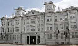 Latrobe Gate, the ceremonial entrance to the Washington Navy Yard | |
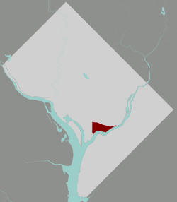 Navy Yard within the District of Columbia | |
| Country | United States |
| District | Washington, D.C. |
| Ward | Ward 6 |
| Government | |
| • Councilmember | Charles Allen |
| Area | |
| • Total | .53 sq mi (1.4 km2) |
| Population (2010) | |
| • Total | 2,794 |
| • Density | 5,300/sq mi (2,000/km2) |
History
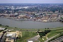
Historically, the Anacostia River was once a deep water channel with natural resources and home to the Nacotchtank Indians. In 1791 Pierre Charles L’Enfant designed the plan for Washington, D.C., and, recognizing the assets of the Anacostia River, located the city's new commercial center and wharfs there. In 1799 the Washington Navy Yard was established in the area and for several decades was the nation's largest naval shipbuilding facility. Today the Washington Navy Yard is the U.S. Navy's longest continuously operated federal facility.[2]
Navy Yard was Washington's earliest industrial neighborhood. One of the earliest industrial buildings was the eight-story brick Sugar House, built in Square 744 at the foot of New Jersey Avenue, SE as a sugar refinery in 1797-98. In 1805, it became the Washington Brewery, which produced beer until it closed in 1836. The brewery site was just west of the Washington City Canal in what is now Parking Lot H/I in the block between Nationals Park and the historic DC Water pumping station.[3]
The Navy Yard was a bustling nautical center during the 19th century and played an integral role in the development of the area. The lively wharf was a hub for jobs, serving ships with lumber and raw materials for the growing city. It also played a key role in defending the city from the British during the War of 1812. Surrounding the wharfs was an extensive commercial district, light industrial businesses, and one of the city's most significant neighborhood communities. As the city and nation evolved, the Navy Yard changed from shipbuilding to production of finished ship products and weapons ammunition. By the mid‑1940s the Navy Yard and the expanded Annex area reached peak production with 26,000 employees in 132 buildings on 127 acres (0.51 km2) of land.[2]
However, during the 20th century the river deteriorated due to pollution. After World War II, the Navy Yard consolidated its operations to a smaller campus, which slowed the economic and neighborhood activity of the area. Furthermore, around this same time, the elevated portion of Interstate 395 was completed, creating a physical barrier for access to the river. The confluence of these factors led the riverfront neighborhoods to become neglected and overrun with crime.[2]
For many years, the neighborhood was home to eight LGBT bars and nightclubs that have since been displaced. Velvet Nation was a weekly dance event that took place at the nightclub Nation. The club, formerly known as The Capitol Ballroom, hosted musical acts such as The Ramones, Björk, David Bowie, Eminem, and Prince.
In 2013, the neighborhood was the site of the Washington Navy Yard shooting.
Redevelopment
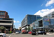
Long an industrial district, the neighborhood has undergone transformation since the 1990s. The area formerly contained a commercial and adult-entertainment district, which has now been displaced. The construction of the U.S. Department of Transportation office complex and Nationals Park, the 2008 $600 million stadium of the Washington Nationals Major League Baseball team, have stimulated growth in the neighborhood.[4] Most of the neighborhood's land and businesses have been purchased by companies and is currently being developed into commercial and residential projects.[5] Current plans are to construct 12 to 15,000,000 square feet (1,400,000 m2) of office space, 9,000 residential units, 1,200 hospitality rooms, 800,000 square feet (74,000 m2) of retail space, four public parks, and an Anacostia Riverwalk trail system.[6]
Projects
- Florida Rock is a 5.8-acre (2.3 ha) site that will consists of 1,100,000-square-foot (100,000 m2) project in four buildings. It will contain 470,000 square feet (44,000 m2) of office space, 84,000 square feet (7,800 m2) of retail, 320,000 square feet (30,000 m2) of residential units, and a 236,000-square-foot (21,900 m2) hotel. There will also be two underground levels of parking with 1,087 spaces and green roofs and biofiltration systems. Construction is scheduled to start in the fall of 2009.[7]
- A new Frederick Douglass Memorial Bridge will be constructed beginning in 2011. The bridge will be shifted slightly to the south from its current location, possibly terminating in a new traffic rotary to be called Potomac Circle at South Capitol, R, and Potomac Streets.[8]
- The Yards is a public-private partnership spanning 40 acres (16 ha), 1,800,000 square feet (170,000 m2) of office space, 2,800 residential units, 160,000 to 350,000 square feet (15,000 to 33,000 m2) of retail space, and a 5.5-acre (2.2 ha) riverfront park. The first construction (400 residential units) began in 2007 and the entire project is to be completed in three phases over 10–20 years.[9]
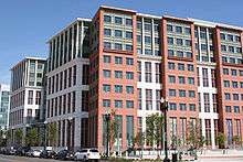
- In 2007, The United States Department of Transportation (USDoT) relocated to the area with a new 1,350,000-square-foot (125,000 m2) facility on 11 acres (4.5 ha), housing 7,000 workers. Building 170, a former electrical substation used by the Washington Navy Yard, is now owned by the USDoT.[10]
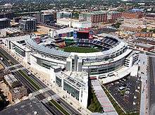
- Opening for the 2008 season, the new Nationals Park seats 41,000.[11]
- The Ballpark District will contain 465,000 to 785,000 square feet (43,200 to 72,900 m2) of retail/restaurant space, 350,000 to 1,600,000 square feet (33,000 to 149,000 m2) of office space, 1,900,000 to 3,600,000 square feet (180,000 to 330,000 m2) (1570 to 2980 units) of residential space, and 7,000-8,000 parking spaces.[12]
- Arthur Capper/Carrollsburg is a 23-acre (9.3 ha) redevelopment of the Capper/Carrollsburg public housing project as mixed-income residential units. The 700 Capper public housing units will be replaced one-for-one, and added to them will be another 700-plus market-rate and workforce-rate rental and ownership units. There will also be 730,000 square feet (68,000 m2) of office space and 50,000 square feet (4,600 m2) of retail space. The first townhouses will begin construction in early 2008.[13]
- Capper Community Center is replacing the current one at 5th and K Streets, and will include a daycare facility for 66 children, rec center, computer lab, gym, game room, and meeting/classrooms.[14]
- New Marine barracks have been built in the area and were opened in 2003. In 1999, the DC Housing Authority transferred to the Department of the Navy approximately six acres of the Arthur Capper Dwellings site at 7th and K Streets, SE, for the development of Bachelor Enlisted Quarters, parking, personnel support and recreational facilities.[15]
- The Barracks Row historic commercial district along 8th Street SÉ has the greatest remaining concentration of historic structures in the Near Southeast, and provides a strong connection between Capitol Hill and the Navy Yard. Development of this area is in the beginning stages, but at least one property has been bought by developers for US$25 million, and will be a new building containing 100,000 square feet (9,300 m2) of office space.[16][17]
- Maritime Plaza is a new development on East M Street. The first two phases (Buildings 1 and 2) have already been completed. The first building contains 345,000 square feet (32,100 m2) of office space, while the second houses contractors working with the navy. Phases 3 and 4 are each 175,000 square foot/7-story office buildings. There are also plans for a 250-room 8-story hotel at the southwestern edge of the property.[18]
- Washington Canal Park is named for the historic Washington Canal, which provided a water-borne connection between the Anacostia River and the Potomac River via the National Mall. Designers envision "trees, grass, plants, a splash pool, aquatic garden and fountain. Officials say runoff from area buildings will be filtered and recycled and used in the water features."[19]
- Diamond Teague Park is a planned $16 million 39,000-square-foot (3,600 m2) public plaza (also referred to as the "First Street Plaza" or "First Street Landing") at the terminus of First Street envisioned as the principal "window" between the new baseball stadium and the river. It is expected to be constructed in phases in coordination with the redevelopment projects at Florida Rock.[20]
- Audi Field is the new home of the D.C. United MLS team, adjacent to Nationals Park.[21]
See also
Michael Shiner, 19th century diarist and Navy Yard worker
References
- DC Council Members
- Capitol Riverfront BID | History of the Neighborhood
- Peck, Garrett (2014). Capital Beer: A Heady History of Brewing in Washington, D.C. Charleston, SC: The History Press. ISBN 978-1626194410.
- Dana Hedgpeth - Contesting a Stadium's Power - washingtonpost.com
- A Transformed Neighborhood Awaits Stadium
- Capitol Riverfront BID | Neighborhood Dynamic
- FRP/RiverFront - Near Southeast DC Revitalization
- South Capitol Street/Frederick Douglass Bridge - Near Southeast DC Revitalization
- "The Yards"/Southeast Federal Center - Near Southeast DC Revitalization
- Department of Transportation HQ - Near Southeast DC Revitalization
- Nationals Park - New DC Baseball Stadium for the Washington Nationals
- DC Ballpark District
- Capper/Carrollsburg Housing Redevelopment - Near Southeast DC Revitalization
- New Community Center at Capper/Carrollsburg - Near Southeast DC Revitalization
- New Marine Bachelor Enlisted Quarters
- Madison Marquette Acquires 770 M Street Near New Nationals Baseball Stadium in Washington, DC - Madison Marquette
- 8th Street Historic District - Near Southeast DC Revitalization
- East M Street - Near Southeast DC Revitalization
- Washington Canal Park - Near Southeast DC Revitalization
- Diamond Teague Park/Earth Conservation Corps
- https://www.dcunited.com/audi-field
External links
| Wikimedia Commons has media related to Navy Yard, Washington, D.C.. |
- ANC 6B ANC 6D, Navy Yard's Advisory Neighborhood Commissions
- "A Neighborhood's Evolution", news reports and interactive map, by The Washington Post
- JDLand, news reports and pictures of Navy Yard's urban renewal
- Capital Riverfront, Navy Yard's business improvement district
| ||||||||||