Brookland (Washington, D.C.)
Brookland is a neighborhood located in the Northeast (NE) quadrant of Washington, D.C. Historically centered along 12th Street NE, Brookland is bounded by either Taylor Street or Michigan Avenue NE to the north, Rhode Island AvenueNE to the south, South Dakota Avenue NE to the east, and the Washington Metro's Red Line to the west.[1] The western boundary originates with the completion of the former Metropolitan Branch of the Baltimore and Ohio Railroad in 1873,[2] which now incorporates the Washington Metro's Red Line and creates the physical barrier which continues to separate Brookland from Edgewood to the west today.
Brookland | |
|---|---|
Neighborhood of Washington, D.C. | |
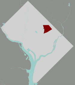 Brookland within the District of Columbia | |
| Coordinates: 38.9275°N 76.99°W | |
| Country | United States |
| District | Washington, D.C. |
| Ward | Ward 5 |
| Government | |
| • Councilmember | Kenyan McDuffie |
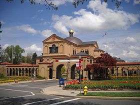
Most of the Brookland neighborhood is served by the Brookland–CUA Metro station, which operates on the Washington Metropolitan Area Red Line, though a small portion of the Brookland neighborhood located on Rhode Island Avenue NE is served by the Rhode Island Avenue Metro Station, which also operates on the Washington Metropolitan Area Red Line as well.
Landmarks
- Fort Bunker Hill
- Newton Theater
- Dahlgreen Courts
- Brooks Mansion
- Ralph Bunche House
- Quincy House
- Charles Richard Drew Memorial Bridge
- Bunker Hill Elementary School
- Brookland Middle School
- Elsie Whitlow Stokes Public Charter School
- Shining Stars Montessori Public Charter School
- Luke C. Moore SHS
- Hope Community Public Charter School, Tolson Campus
- Mary McLeod Bethune Day Academy Public Charter School
- Franciscan Monastery and the St. Francis Hall
- Benjamin Mays Hall (formerly, College of the Holy Name)
- Turkey Thicket playground and recreation center
- St. Anthony's Catholic School & Church
- King David Masonic Lodge
- The Round House
History
In 1632 the English Crown unilaterally took the land from the Piscataway Indians who inhabited the Potomac-Anacostia region and King Charles I of England in turn granted the land, which was to become the state of Maryland, to George Calvert, whose interest in the colony lay in "the sacred duty of finding a refuge for his Roman Catholic brethren."[3] It took until about 1675 for English settlers to reach what is now the DC area, after defeating the Powhatans in 1645, and with the help of diseases that reduced the Indian numbers by perhaps 90%.
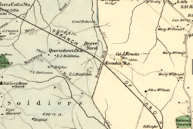
Colonel Jehiel Brooks married into the land when he married Ann Margaret Queen, daughter of Nicholas Queen, and they received a 150-acre estate.[4]
For most of the 19th century the area was farmland owned by the prominent Middleton and Queen families. The Baltimore and Ohio Railroad later connected this portion of Washington County to downtown. Bellair, the 1840 brick Greek Revival mansion built by Colonel Jehiel Brooks, still stands. It is referred to as Brooks Mansion. It is the site of offices and production facilities for the Public Access Corporation of the District of Columbia, the city's Government-access television (GAVT) channel known as DCTV.
Change came rapidly during and after the American Civil War. First, Fort Slemmer and Fort Bunker Hill were constructed as defenses against the Confederate Army, and later the Old soldiers' home was constructed to the northwest. The population of the city itself increased with the expansion of the federal government, and the former Brooks family estate became a housing tract named "Brookland."
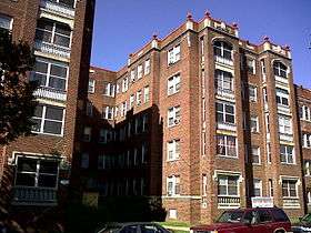
Growth continued throughout the 1870s when the Baltimore and Ohio Railroad opened its Western Branch Line in the developing Brookland neighborhood.[5] With the construction of nearby Sherwood, University Heights, and other tracts, and the expansion of Washington's streetcars, a middle-class streetcar suburb developed, and eventually its expansion southward met Washington's northward. Many Queen Anne style and other Victorian homes still stand.
The transition from a country estate towards a residential development beginning in 1887 "marked the extension of suburban growth into the rather isolated reaches of the northeastern sector" of D.C.[6] In its early days, the Brookland community was marked by "spacious lots and single family homes" which appealed to middle-class families and provided a "small town atmosphere.[6]"
Catholic institutions
Brookland, together with its surrounding neighborhoods, has been at times referred to as "Little Rome" because of the many Catholic organizations and institutions clustered around the Catholic University of America.[7] The university itself does not lie within Brookland's borders, but since the Catholic Church purchased the Middletown estate, adjacent to Brookland, in 1887, many Catholic groups have established themselves there and in the neighboring communities of Edgewood and Michigan Park. Ordered by year of establishment, major Catholic organizations that are physically located in Brookland include:
- Franciscan Monastery of the Holy Land in America (1905) and St. Francis Hall (1931)
- Holy Name College (1931–1984)[8]
- Poor Clares of Perpetual Adoration Convent (1954–2017), Sisters of Life Convent (2017–present)[9]
- Archdiocese for the Military Services, USA (1986)
From 1984 until 2015, the Franciscans’ Holy Name College had served as the Howard University School of Divinity’s East Campus.[10][11] As a divinity school, the institution did not solely focus on Christianity or Catholicism. Rather, it sought to educate students in scripture and theology generally, and to prepare them to be academics or to be ordained to serve as clergy. In 2016, the Urban Land Institute studied the site and engaged community stakeholders to determine potential development that might take place at the location. As of 2017, the site is scheduled to be redeveloped into a living-learning campus with current historic structures and open space preserved.[12]
Community diversity
With its residents mostly of European descent at its founding, and with restrictive covenants against Jews and African-Americans in some developments , Brookland eventually integrated in the 20th century, especially after white flight took place following World War II and the US Supreme Court ruled in 1948 that restrictive covenants were unenforceable . Although there was some hostility directed at early black integration of the neighborhood, by the 1970's Brookland had developed into a neighborhood fairly integrated among economic classes and races. During the mid-twentieth century, Brookland could boast of such prominent residents as Ralph Bunche, Sterling Allen Brown, Edward Brooke, Ellis O. Knox, Rayford W. Logan, Pearl Bailey, John P. Davis, Marvin Gaye, Paul Tsongas, Lucy Diggs Slowe, Lois Mailou Jones, and Robert C. Weaver. It remains a relatively diverse and stable area of Washington. African American architect Romulus C. Archer designed homes, buildings, and churches in the area.[13]
Brookland was also home to the playwright Jean Kerr and her playwright/critic husband Walter Kerr, who taught at nearby CUA. The writer Marjorie Kinnan Rawlings spent her childhood in Brookland.
Justine Ward, the music educator and author, lived in Brookland and built the large residence now occupied by the Servants of the Lord and the Virgin of Matara in the 1300 block of Quincy Street. CUA's School of Music is named in Ward's honor. Also on Quincy Street is the Quincy House, a long-time residence of Catholic graduate students who regularly host coffee houses and other community events.
Businesses
Brookland Hardware anchored 12th Street NE for many years until it closed in November 2015; for hardware, locals either go to Annie's Ace Hardware about five blocks to the west, in Edgewood on the other side of the Red Line, or to Home Depot just south of Rhode Island Avenue. However, many full-service restaurants still make the thoroughfare a bustling corridor. These include: Brookland's Finest, Menomale, San Antonio Grill, Masala Story , Primrose (aka Larry's Chicken and Cheeseburgers) and Murray and Paul's, which is only open for breakfast. New additions in 2016 included Pho12 and Salumeria Italiana, an Italian deli from the owners of Menomale. Additionally, there are also a few carry-out restaurants including Today's Pizza, Pizza Boli's, and Sammy Carry-Out. Other businesses found along 12th street include Yes! Organic Market, Good Food Market , Openbox9 Graphic Design Studio, along with realtors, auto-mechanics, a 7-11, nail and hair salons, florists, dry cleaners, and liquor stores. District Veterinary Hospital is located on 10th Street. Right Proper Brewery's Production House & Tasting Room is also located in the neighborhood. Tastemakers, a commercial kitchen for small, local food businesses and a food hall open to the public is also located in the Brookland neighborhood.[14]
In November 2011, D.C. based real estate developer Abdo broke ground on a large mixed-use development spread over a previously underutilized 8.9 acre plot.[15] The project, known as Monroe Street Market, was fully completed in 2014. Despite the word "BROOKLAND" prominently painted on the main building, the entire complex lies within neighboring Edgewood.[16][17] This area includes 27 artists' studios on an "Arts Walk," a Barnes & Noble (CUA's bookstore), a Potbelly Sandwich Works, a Chipotle Mexican Grill, a Starbucks, and local chain Busboys and Poets. While there are new projects slated for 2017/2018, at least part of the community believes the area is being overly developed, which has led to a few court battles with developers.[18] A nearly-full-block parcel on Monroe Street between 9th and 10th Streets, formerly the site of Colonel Brooks' Tavern, remains vacant at this time because of conflicts between neighbors and developers over the height of the planned mixed-use complex.
References
- https://goo.gl/maps/RHgnXHgo4LA1LhoeA Brookland Map
- "The Metropolitan Railroad" (PDF). The Evening Star. Washington, D.C. April 30, 1873. p. 4.
- "America as a Religious Refuge: The Seventeenth Century, Part 2 - Religion and the Founding of the American Republic | Exhibitions (Library of Congress)". www.loc.gov. Retrieved 2015-09-16.
- McDaniel, George W.; Pearce, John N.; Aurand, Martin, eds. (1988). Images of Brookland: The History and Architecture of a Washington Suburb. Washington, D.C.: Center for Washington Area Studies, George Washington University. p. 7. OCLC 8973194.
- Brookland Neighborhood Finding Aid, Special Collections Research Center, Estelle and Melvin Gelman Library, The George Washington University
- McDaniel, George W.; Pearce, John N.; Aurand, Martin, eds. (1988). Images of Brookland: The History and Architecture of a Washington Suburb. Washington, D.C.: Center for Washington Area Studies, George Washington University. p. 3. OCLC 8973194.
- "Debates Over Development In D.C.'s "Little Rome"". The Kojo Nnamdi Show. October 13, 2016. Retrieved 5 January 2017.
- Anderson, Jeffrey (February 2, 2016), "The Catholic Church Is Selling Northeast DC to Developers", Washingtonian, retrieved August 31, 2016
- Seegers, Kelly (June 29, 2017), "Poor Clares of Perpetual Adoration close Washington monastery, trusting in God's providence", Catholic Standard, retrieved August 31, 2018
- Anderson, Jeffrey (February 2, 2016). "The Catholic Church Is Selling Northeast DC to Developers". The Washingtonian. Retrieved 5 January 2017.
- Howard Newsroom Staff (November 3, 2017). "FLGA and ZOM Living Team Selected for Redevelopment and Master Planning". Howard University Office of University Communications. Retrieved 9 July 2019.
- Howard Newsroom Staff (November 3, 2017). "FLGA and ZOM Living Team Selected for Redevelopment and Master Planning". Howard University Office of University Communications. Retrieved 9 July 2019.
- "Archer, Romulus Cornelius, Jr. (1890 - 1968) -- Philadelphia Architects and Buildings". www.philadelphiabuildings.org.
- "About Us". Tastemakers DC. Retrieved 16 May 2019.
- Paul, Shilpi (November 9, 2011). "Brookland's Monroe Street Market Breaks Ground". Urban Turf. Retrieved 5 January 2017.
- https://goo.gl/maps/HfNB5TmHQsv Edgewood Map
- http://www.popville.com/2016/07/edgewood-getting-into-the-branding-game/ Popville (07/08/16)
- Alpert, David (June 2, 2016). "A court ruling on a Brookland development could imperil future housing near Metro stations". Greater Greater Washington. Retrieved 5 January 2017.
External links
| Wikivoyage has a travel guide for Brookland. |
| Wikimedia Commons has media related to Brookland, Washington, D.C.. |
- Brookland Neighborhood Civic Association
- BygoneBrookland (Brookland History)
- 2011 Washington Post article on Brookland
- The Brooks - Queen Family Collection (1773-1979) documents the activities of members of the two families who built the Brooks Mansion.
- Door to Door interview with author of Images of America: Brookland
- Map of Brookland in 1903
Places adjacent to Brookland (Washington, D.C.) | ||||||||||
|---|---|---|---|---|---|---|---|---|---|---|
| ||||||||||