NoMa
"NoMa" (North of Massachusetts Avenue) is a moniker for the area North of Massachusetts Avenue located north and east of Union Station in Washington, D.C., United States. NoMa includes the neighborhoods of Sursum Corda, Eckington, and Near Northeast and includes a section historically known as Swampoodle. Its southern tip is four blocks from Capitol Hill. "NoMa", meaning "North of Massachusetts Avenue", is a syllabic abbreviation on the model of other similarly named neighborhoods such as SoHo and Tribeca.
NoMa | |
|---|---|
Neighborhood of Washington, D.C. | |
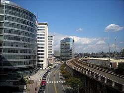 Facing north on First Street, N.E., in "NoMa." The Washington Metro's Red Line track is visible on the right-hand side. | |
| Country | United States |
| District | Washington, D.C. |
| Ward | Ward 6 |
| Government | |
| • Councilmember | Charles Allen |
| Website | https://www.nomabid.org |
After much planning for the area in the late 1990s, the 2004 opening of the New York Ave–Florida Ave Metro, now NoMa-Gallaudet U station, sparked development in the neighborhood. The area is served by many modes of transportation including rail (via the Red Line of the Washington Metro), bus (via intercity carriers and Metrobus), bicycle (including bicycle lanes and Capital Bikeshare stations), Metropolitan Branch Trail), car, taxi, or walk the sidewalks of an area that received a walkscore of 93.[1] Eighteen schools serve the NoMa neighborhood, from pre-K to university.
NoMa includes several historic structures:
External links
| Wikimedia Commons has media related to NoMa, Washington, D.C.. |