Round Prairie Township, Callaway County, Missouri
Round Prairie Township is one of eighteen townships in Callaway County, Missouri, USA. As of the 2010 census, its population was 1038.[3]
Round Prairie Township today | |
|---|---|
 | |
| Coordinates: 38°49′19″N 092°04′46″W | |
| Country | United States |
| State | Missouri |
| County | Callaway |
| Area | |
| • Total | 34.48 sq mi (89.31 km2) |
| • Land | 34.36 sq mi (89 km2) |
| • Water | 0.12 sq mi (0.3 km2) 0.34% |
| Elevation | 860 ft (262 m) |
| Population (2010) | |
| • Total | 1,038 |
| • Density | 30/sq mi (12/km2) |
| FIPS code | 29-63362[2] |
| GNIS feature ID | 0766383 |
Geography
Round Prairie Township covers an area of 34.48 square miles (89.3 km2) and contains the unincorporated settlements of Carrington, near the headwaters of the Missouri River tributary Middle River, and Boydsville, near another Missouri River tributary (Cedar Creek) bordering Boone County, although no incorporated settlements. It contains four cemeteries: Boydsville, Hundley, Millers Creek and Paris Fork; as well as the streams of Davis Creek, Millers Creek and Smith Creek also run through this township.
History
Created in May 14, 1821, the township initially covered at least the northern 2/3 of the western border areas of Callaway County, from 'the township line (boundary?) of 45 and 46 northward to the Audrain County line and eastward to a line along what is now the western boundary of West Fulton Township. If this description refers to boundary between Township 45 and 46, then it equates with a line near the southern city limits of New Bloomfield, explaining historical accounts of a historic Round Prairie Post Office later renamed New Bloomfield Post Office.
In 1824, Round Prairie Township was reduced in size by the creation of Cedar Township to its south from what was the remainder of the western sector of Cote Sans Dessein Township, and within a year, in 1825, Round Prairie Township was further reduced substantially in size with the creation of a larger-than-today Bourbon township from its northern sector. This continued for about 60 years.
A Round Prairie Post Office, from May 30, 1827 to June 16, 1841, 'about one-half mile north of New Bloomfield' was clearly inside Round Prairie Township boundaries of 1824, but near the boundary with the new Cedar Township created in 1825. The history of Round Prairie Post Office is complicated by the changes of township boundaries before and around the time of its opening; the reported move of New Bloomfield southward from its original site (surveyed in 1836 and called 'Bloomfield' before its move southward in 1841); and the later creation of Guthrie Township from parts of Round Prairie and Cedar townships.[4][5](See Missouri State Historical Society on Callaway place name changes.)
Between 1883 and 1897, Round Prairie Township was again reduced in size by the creation of Guthrie Township from its southernmost area, at about the same time that Bourbon township was also reduced in size by the creation of Cleveland Township at the northwest corner of Callaway County).[6] These changes are significant for research on historical events and genealogy. A detailed historic map of Round Prairie township in 1930, with about the same boundaries as exist today, can be found on the last page of the atlas posted at:
Further historical maps and texts describing historic township boundaries are posted in the bibliography of the article on Callaway County, Missouri.
References
- "US Board on Geographic Names". United States Geological Survey. 2007-10-25. Retrieved 2008-01-31.
- "U.S. Census website". United States Census Bureau. Retrieved 2008-01-31.
- "Race, Hispanic or Latino, Age, and Housing Occupancy: 2010 Census Redistricting Data (Public Law 94-171) Summary File (QT-PL), Round Prairie township, Callaway County, Missouri". United States Census Bureau. Retrieved October 31, 2011.
- Kingdom of Callaway Historical Society: 'A History of Callaway County', Fulton MO: 1984.
- Kingdom of Callaway Historical Society: ' Combined Atlas of Callaway County Missouri 1876-1897-1919', Mt Vernon IN: 1994.
- Missouri State Library: History of Callaway County, Missouri. St Louis, National Historical Company, 1884.
External links
Municipalities and communities of Callaway County, Missouri, United States | ||
|---|---|---|
| Cities | 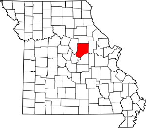 Map of Missouri highlighting Callaway County | |
| Village | ||
| Townships | ||
| Unincorporated communities | ||
| Ghost towns | ||
| Footnotes | ‡This populated place also has portions in an adjacent county or counties | |