Tebbetts, Missouri
Tebbetts is an unincorporated community in southern Callaway County, Missouri, United States. It is part of the Jefferson City, Missouri Metropolitan Statistical Area. Tebbetts is located on Route 94, approximately eight miles east of Jefferson City, on the north edge of the Missouri River floodplain,[1] at 38°37′14″N 91°57′45″W.[2]

A post office called Tebbetts has been in operation since 1895.[3] The community was named after a railroad employee.[4]
The Cote Sans Dessein Archeological Site and Oakley Chapel African Methodist Episcopal Church are listed on the National Register of Historic Places.[5]

Tebbetts Missouri United Methodist Church, Spring 2012

Tebbetts Missouri Bank, Spring 2012
References
- Missouri Atlas & Gazetteer, DeLorme, 2007, Third edition, p. 38, ISBN 0-89933-353-2
- U.S. Geological Survey Geographic Names Information System: Tebbetts, Missouri
- "Post Offices". Jim Forte Postal History. Retrieved 7 September 2016.
- "Callaway County Place Names, 1928–1945 (archived)". The State Historical Society of Missouri. Archived from the original on 24 June 2016. Retrieved 7 September 2016.CS1 maint: BOT: original-url status unknown (link)
- "National Register Information System". National Register of Historic Places. National Park Service. July 9, 2010.
Municipalities and communities of Callaway County, Missouri, United States | ||
|---|---|---|
| Cities | 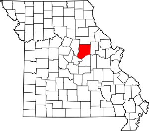 Map of Missouri highlighting Callaway County | |
| Village | ||
| Townships | ||
| Unincorporated communities | ||
| Ghost towns | ||
| Footnotes | ‡This populated place also has portions in an adjacent county or counties | |
This article is issued from Wikipedia. The text is licensed under Creative Commons - Attribution - Sharealike. Additional terms may apply for the media files.