Red Line (Washington Metro)
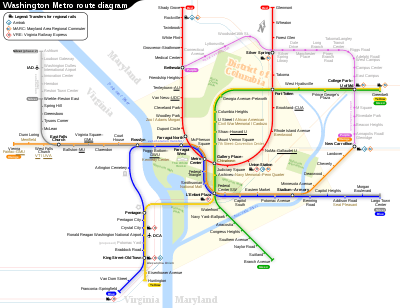
The Red Line is a rapid transit line of the Washington Metro system, consisting of 27 stations in Montgomery County, Maryland, and Washington, D.C., in the United States. It is a primary line through downtown Washington and the oldest, busiest, and longest line in the system. It forms a long, narrow "U", capped by its terminal stations at Shady Grove and Glenmont.

Trains run most frequently during morning and evening rush hours (nominally four to eight minutes apart) and least frequently after 9:30 p.m. (nominally 15 to 18 minutes apart).[1]
The Red Line is the only line in the system that does not share its tracks with another Metrorail line. However, it runs parallel to the Metropolitan Subdivision between Washington Union Station and Silver Spring as well as between Twinbrook and Shady Grove stations. These tracks used to be part of the former Baltimore and Ohio Railroad route. The MARC commuter rail system uses this parallel route with stops in Silver Spring and Rockville when traveling between Washington and Martinsburg, West Virginia, while Amtrak uses this parallel route with a stop in Rockville when traveling the Capitol Limited route between Washington, D.C. and the Chicago Union Station.
History
Planning for Metro began with the Mass Transportation Survey in 1955 which attempted to forecast both freeway and mass transit systems sufficient to meet the needs of 1980.[2] In 1959, the study's final report included two rapid transit lines which anticipated subways in downtown Washington.[3] Because the plan called for extensive freeway construction within the District of Columbia, alarmed residents lobbied for federal legislation creating a moratorium on freeway construction through July 1, 1962.[4] The National Capital Transportation Agency's 1962 Transportation in the National Capital Region report anticipated much of the present Red Line route, with the Red Line following the Baltimore and Ohio Railroad right-of-way between Silver Spring and Rockville instead of a direct route between Bethesda and Rockville.[5] The route continued in rapid transit plans until the formation of WMATA.
With the formation of WMATA in October 1966,[6][7] planning of the system shifted from federal hands to a regional body with representatives of the District, Maryland and Virginia. Congressional route approval was no longer a key consideration.[8] Instead, routes had to serve each local suburban jurisdiction to assure that they would approve bond referenda to finance the system.[9] Because the least expensive way to build into the suburbs was to rely upon existing railroad right-of-ways, the Red Line took much of its present form, except that it continued to feature a further link between its two stems along the Baltimore and Ohio Railroad right-of-way.[10]
By 1969, WMATA had decided on the current routing and stations, except for the extension beyond Rockville to Shady Grove.[11] Montgomery County officials opposed ending the Red Line in downtown Rockville, saying it would cause congestion in the area and use scarce vacant land for a storage yard.[12] Metro decided to propose to extend the red line one more station to Shady Grove and the U.S. Department of Transportation conditionally approved funding for the extension on July 26, 1975.[12] Construction on the Red Line began with a groundbreaking ceremony at Judiciary Square on December 9, 1969.[13] Construction proved difficult because the National Park Service prohibited a bridge across Rock Creek and required that the Red Line tunnel under that valley, the tunnel in turn caused both the Dupont Circle and Woodley Park stations to be built further underground.[14] The Red Line was proposed to tunnel under Yuma Street from Connecticut Avenue to Wisconsin Avenue, but local residents sued and that court case delayed construction of the tunnel for two years, then WMATA finally won the right to build the tunnel there.[15]
Service on the Red Line (and the Metro as a whole) began on March 27, 1976, with operation between Farragut North and Rhode Island Avenue.[16][17] Gallery Place's opening was delayed due to a court order regarding lack of handicapped access, but it opened in the middle of the line on December 15, 1976.[17] The western end of the line was extended one station to Dupont Circle on January 17, 1977, three stations to Van Ness–UDC on December 5, 1981, five stations to Grosvenor–Strathmore on August 25, 1984 and four stations to Shady Grove on December 15, 1984.[17] The eastern end was extended four stations to Silver Spring on February 6, 1978—which added Maryland to the system for the first time — two stations to Wheaton on September 22, 1990, and one station to Glenmont on July 25, 1998, completing the line.[17]
The only time the Red Line shared tracks with another line was from January 27, 1997 to September 17, 1999, when the Green Line Commuter Shortcut used Red Line tracks from Brookland–CUA to Farragut North. A short time after the Green Line branch north of Fort Totten opened in the early 1990s, the "Green Line Commuter Shortcut" began as a six-month experiment. Passengers could board the Green Line between Greenbelt and West Hyattsville and travel as far as Farragut North without having to transfer; the trains bypassed Fort Totten via a single-track spur between the West Hyattsville and Brookland–CUA stations. Due to its success, the shortcut continued until the mid-city portion of the Green Line was completed in 1999.[18]
The NoMa–Gallaudet University station (formerly New York Ave–Florida Ave–Gallaudet University), located between Union Station and Rhode Island Avenue–Brentwood, opened on November 20, 2004. It was the system's first infill station (i.e., a new station built between existing stations).[19]
From March 26, 2020 until June 28, 2020, trains were bypassing Grosvenor–Strathmore, Cleveland Park, and Judiciary Square stations due to the 2020 coronavirus pandemic.[20][21] All stations were reopened beginning on June 28, 2020.[22]
Incidents and Accidents
2004 Woodley Park accident
On November 3, 2004, an out-of-service Red Line train rolled backward into the Woodley Park station and hit an in-service train stopped at the platform. No one was killed, but 20 people were injured.[23] A 14-month investigation concluded that the train operator was most likely not alert as the train rolled backward into the station. Safety officials estimated that had the train been full, at least 79 would have died. The train operator was dismissed and Metro officials agreed to add rollback protection to more than 300 rail cars.[24]
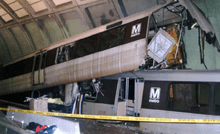
2009 train collision
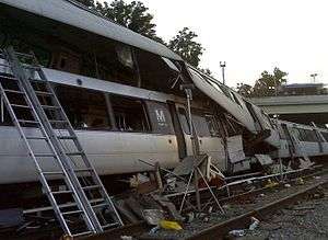
On the evening of June 22, 2009, at 5:03 p.m., two Red Line trains collided when traveling between the Takoma and Fort Totten Metro stations. A stationary train was struck from behind by a second six-car train, resulting in the telescoping of the moving train onto the rear of the stationary train. Nine people were killed in the collision (eight passengers and the train operator) and at least 70 people were injured. It is the deadliest accident in the history of the Washington Metro.[25] The National Transportation Safety Board report on the accident was released on July 27, 2010, which blamed a faulty track circuit, part of the automatic train control system, for causing the crash.[26][27] WMATA made a press release detailing changes on July 26 in anticipation of the release.[28]
Chronology
Below is a chronological list of dates on which specific portions of the Red Line opened for service.[17]
| Date | Event | Total number of stations | Total line length |
|---|---|---|---|
| March 29, 1976 | Line opens between Farragut North and Rhode Island Avenue | 5 | 4.6 mi (7.4 km) |
| December 15, 1976 | Gallery Place–Chinatown opens between existing stations | 6 | 4.6 mi (7.4 km) |
| January 1, 1977 | Extension to Dupont Circle opens | 7 | 5.7 mi (9.2 km) |
| February 6, 1978 | Extension to Silver Spring opens | 11 | 11.4 mi (18.3 km) |
| December 5, 1981 | Extension to Van Ness-UDC opens | 14 | 13.5 mi (21.7 km) |
| August 25, 1984 | Extension to Grosvenor-Strathmore opens | 19 | 20.3 mi (32.7 km) |
| December 15, 1984 | Extension to Shady Grove opens | 23 | 27.3 mi (43.9 km) |
| September 22, 1990 | Extension to Wheaton opens | 25 | 30.5 mi (49.1 km) |
| January 25, 1998 | Extension to Glenmont opens | 26 | 31.9 mi (51.3 km) |
| November 20, 2004 | NoMa–Gallaudet U opens between existing stations | 27 | 31.9 mi (51.3 km) |
Route
The Red Line begins above ground at Shady Grove, and parallels CSX Transportation's Metropolitan Subdivision (served by MARC Brunswick Line trains) to south of Twinbrook. The route then enters a tunnel and curves west to run under Rockville Pike at White Flint. Until Tenleytown, the line follows the route of Rockville Pike and Wisconsin Avenue in a tunnel, except for a bridge over the Capital Beltway (I-495). The tunnel curves east at Tenleytown into Yuma Street to reach the Van Ness–UDC station, curving south there to travel under Connecticut Avenue through south of Farragut Square. A curve under Lafayette Park takes the tunnel east under G Street Northwest through the Metro Center and Gallery Place stations.[29]:178
From Gallery Place through Judiciary Square, the line runs southeast, turning east again at D Street to reach Union Station. There it turns north and surfaces adjacent to Union Station's platforms, follows the Washington Terminal yard tracks north to Brentwood where the line turns northwestward and again joins CSX Transportation's Metropolitan Subdivision tracks, running in a unique gauntlet arrangement with the freight railroad tracks straddling the Metro tracks. The Red Line continues in this manner northwest across the DC-Maryland line, through Takoma and past Silver Spring. It reenters a tunnel at 16th Street and heads north under Georgia Avenue to the end at Glenmont.[29]:188 There is a maintenance yard between the NoMa–Gallaudet and Rhode Island Avenue–Brentwood stops.[30]
Internally, WMATA calls the Red Line the Shady Grove Route (A) and the Glenmont Route (B), which meet at Metro Center.[29]
The Red Line needs 44 trains (10 eight-car trains and 34 six-car trains, consisting of 284 rail cars) to run at peak capacity.[31] Trains run most frequently during morning and evening rush hours (nominally four to eight minutes apart) and least frequently after 9:30 p.m. (nominally 15 to 18 minutes apart).[1]
The Red and Green Lines are the only lines that do not enter Virginia.
Stations
The line serves the following stations, from northwest to northeast:[32]
| Station | Code | Opened[17] | Image | Transfers/Connections |
|---|---|---|---|---|
| Shady Grove | A15 | 1984 |  | |
| Rockville | A14 | 1984 |  | |
| Twinbrook | A13 | 1984 |  | |
| White Flint | A12 | 1984 |  | |
| Grosvenor–Strathmore | A11 | 1984 |  | |
| Medical Center | A10 | 1984 |  | |
| Bethesda | A09 | 1984 | 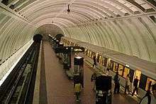 | |
| Friendship Heights | A08 | 1984 | 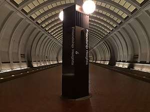 | |
| Tenleytown–AU | A07 | 1984 | 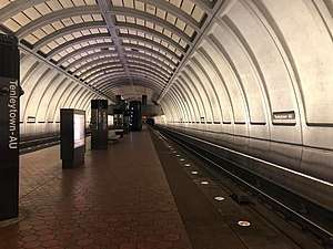 | |
| Van Ness–UDC | A06 | 1981 |  | |
| Cleveland Park | A05 | 1981 | 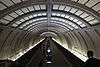 | |
| Woodley Park | A04 | 1981 | 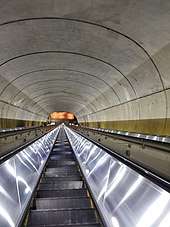 | |
| Dupont Circle | A03 | 1977 |  | |
| Farragut North | A02 | 1976 |  |
|
| Metro Center | A01 | 1976 | .jpg) |
|
| Gallery Place | B01 | 1976 | _(4985077674).jpg) |
|
| Judiciary Square | B02 | 1976 |  |
|
| Union Station | B03 | 1976 |  |
Northeast Regional, Palmetto, Silver Meteor, Silver Star, Vermonter |
| NoMa–Gallaudet U | B35 | 2004 |  |
Infill station, built in 2004 between two existing stations built in the 1970's. The first infill station on the
metrorail network. |
| Rhode Island Avenue–Brentwood | B04 | 1976 |  |
|
| Brookland–CUA | B05 | 1978 |  |
|
| Fort Totten | B06 | 1978 |  |
|
| Takoma | B07 | 1978 |  |
|
| Silver Spring | B08 | 1978 |  |
|
| Forest Glen | B09 | 1990 |  |
Deepest station on the metrorail network. The only station without escalators—elevators being the only way to access the platforms. |
| Wheaton | B10 | 1990 |  |
Second deepest station on the metrorail network. At 230 feet long, this station has the longest escalators
in the western hemisphere. |
| Glenmont | B11 | 1998 |  |
Future
In November 2010, the WMATA authorized $37 million in capital improvements on the Red Line. This is a part of $212 million of work on the Red Line scheduled over 2010–2014.[33] In December 2009, WMATA began construction of a new 1,200-car parking garage to supplement the existing 1,700-car parking garage at the Glenmont station. The new garage opened in April 2012[34] and was funded by the State of Maryland.[35]
In 2011, as part of a preliminary study, the WMATA examined the possibility of extending the Red Line past the Shady Grove station and to the Metropolitan Grove station by 2040.[36][37][38][39]
On the east side of Rockville Pike, a new entrance to the Medical Center station is under construction, as well as a pedestrian tunnel under Rockville Pike to connect the entrance to the station. Currently, about 7,000 riders per day emerge from the station on the west side of the Pike, then cross the busy six-lane road to reach the Walter Reed National Military Medical Center.[40] In September 2009, Montgomery County submitted a $20 million federal grant application. Construction would have originally occurred in 2011,[41] but the project was not approved until 2013.[42] The project is fully funded at $68 million, mostly through the Department of Defense, and includes installation of new deep elevators, improvement of surface bicycle and pedestrian facilities, as well as an extension of the left turn lane on southbound MD 355. The project began construction in December 2017, and is expected to be completed in late 2021.[43][44]
References
- "Timetables | WMATA". www.wmata.com. Retrieved 2019-04-18.
- Schrag (2006), p. 33-38.
- Schrag (2006), p. 39.
- Schrag (2006), p. 42.
- Schrag (2006), p. 55.
- "Washington Metropolitan Area Transit Authority Compact" (PDF). WMATA. August 2009. Retrieved March 28, 2018.
- "D.C. Area Transit Compact Approved". The Baltimore Sun. October 14, 1966. p. A10. ProQuest 539537151.
- Schrag (2006), p. 104.
- Schrag (2006), p. 108.
- Schrag (2006), p. 110.
- Financing Subway System for National Capital Region: Joint Hearings Before the Committee on the District of Columbia and the Subcommittee No. 4 of the Committee on the District of Columbia. 1969. p. 129.
- Eisen, Jack (July 27, 1975). "Rockville and Greenbelt Lines Are Funded by U.S. for Metro". The Washington Post. p. 9. ProQuest 146254407.
- "WMATA History" (PDF). WMATA. Retrieved March 28, 2018.
- Schrag (2006), p. 151.
- Schrag (2006), p. 160.
- Rosenthal, Harry (March 26, 1976). "First section of new subway system opens". Daily News. p. 14. Retrieved December 11, 2010.
- "Sequence of Metrorail openings" (PDF). Washington Metropolitan Area Transit Authority. 2017. p. 3. Retrieved March 28, 2018.
- "Metro – Community Outreach – Lunchtalk Online Chat". WMATA. March 6, 2009. Archived from the original on July 26, 2012. Retrieved March 3, 2011.
- "Metro's New York Ave-Florida Ave-Gallaudet U Metrorail station opens today on the Red Line". WMATA. November 20, 2004. Retrieved March 28, 2018.
- "Special Covid-19 System Map" (PDF). Washington Metropolitan Area Transit Authority. Retrieved April 14, 2020.
- "Metrorail stations closed due to COVID-19 pandemic". Washington Metropolitan Area Transit Authority. March 23, 2020. Retrieved April 14, 2020.
- "Metro to reopen 15 stations, reallocate bus service to address crowding, starting Sunday | WMATA". www.wmata.com. Retrieved 22 June 2020.
- Layton, Lyndsey; Steven Ginsberg (2004-11-04). "20 Injured in Crash of 2 Red Line Trains". The Washington Post. pp. A01. Retrieved 2009-01-27.
- Sun, Lena H. (March 23, 2006). "Dozing Operator Blamed in Rail Accident". The Washington Post. p. A01.
- Saslow, Eli (June 28, 2009). "Three Minutes to Fort Totten". The Washington Post. Retrieved June 30, 2009.
- "Fatal Washington Metro Crash Shows Need for U.S. Transit Rules, NTSB Says". Bloomberg. July 27, 2010. Retrieved July 28, 2010.
- "Washington Metropolitan Area Transit Authority Rear-end collision: Accident Report Detail". NTSB. May 17, 2012. Retrieved March 28, 2018.
- "Metro demonstrates safety commitment, compliance with NTSB recommendations, including replacement of 1000 series rail cars" (Press release). WMATA. July 26, 2010. Retrieved March 28, 2018.
- Metro Draft Environmental Statement, WMATA, February 1973
- "WMATA Red Line". nycsubway.org. Retrieved March 28, 2018.
- "Approved Fiscal 2009 Annual Budget" (PDF). Washington Metropolitan Area Transit Authority. 2009. p. 80.
- "Metro System Map" (PDF). WMATA. Retrieved March 28, 2018.
- "Overhaul of the Red Line continues". WMATA. November 18, 2010. Retrieved December 10, 2010.
- Reed, Dan (April 26, 2012). "Can a parking deck be "green"? New Glenmont garage isn't". Greater Greater Washington.
- Parcher, Amber (November 11, 2009). "Metro unveils design for Glenmont parking garage". Montgomery County Gazette. Retrieved December 10, 2010.
- "Meeting" (PDF). planitmetro.com. Retrieved 2020-06-17.
- "TAG Meeting #7: Analysis of Enhanced Surface Transit, Metrorail Extensions, and New Metrorail Lines Through and Around the Core". planitmetro.com. May 5, 2011. Retrieved 2020-06-17.
- "Metro planners contemplate system's second generation". ggwash.org. June 21, 2011. Retrieved 2020-06-17.
- "Five (mostly rejected) ideas for Metro expansion you've probably forgotten about". ggwash.org. January 22, 2018. Retrieved 2020-06-17.
- Waibel, Elizabeth (February 13, 2013). "New entrance, pedestrian tunnel planned for Medical Center Metro". Montgomery County Gazette. Retrieved April 21, 2013.
- Ujifusa, Andrew (September 16, 2009). "County proposes underpass for Medical Center Metro station". Montgomery County Gazette. Retrieved December 10, 2010.
- "Medical Center Metro Crossing Project". Montgomery County Government. Retrieved February 11, 2018.
- Martinez, Julio (January 11, 2018). "Tunnel to be Built for Pedestrian Use". DC Military. Retrieved February 11, 2018.
- Brooks, Jeremy (January 11, 2018). "Progress to Continue on MD 355 Crossing Project through 2018". DC Military. Retrieved February 11, 2018.
Further reading
- Schrag, Zachary (2006). The Great Society Subway: A History of the Washington Metro. Baltimore, MD: Johns Hopkins University Press. ISBN 0-8018-8246-X.CS1 maint: ref=harv (link)
External links
| Wikimedia Commons has media related to Red Line (Washington Metro). |
| Subsidiaries | |
|---|---|
| Metrorail lines | |
| Bus rapid transit | |
| Other topics | |
| Agencies | |
|---|---|
| Washington Metro | |
| Commuter rail | |
| Regional rail | |
| Bus |
|
| Bus rapid transit | |
| Streetcar | |
| Aviation | |
| Future projects | |