Auriac, Pyrénées-Atlantiques
Auriac is a commune in the Pyrénées-Atlantiques department in the Nouvelle-Aquitaine region of south-western France.
Auriac | |
|---|---|
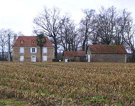 Bearnais house in Auriac | |
Location of Auriac 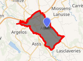
| |
 Auriac  Auriac | |
| Coordinates: 43°27′23″N 0°18′53″W | |
| Country | France |
| Region | Nouvelle-Aquitaine |
| Department | Pyrénées-Atlantiques |
| Arrondissement | Pau |
| Canton | Terres des Luys et Coteaux du Vic-Bilh |
| Intercommunality | CC Luys Béarn |
| Government | |
| • Mayor (2014-2020) | Christian Larrouturou |
| Area 1 | 5.23 km2 (2.02 sq mi) |
| Population (2017-01-01)[1] | 238 |
| • Density | 46/km2 (120/sq mi) |
| Time zone | UTC+01:00 (CET) |
| • Summer (DST) | UTC+02:00 (CEST) |
| INSEE/Postal code | 64078 /64450 |
| Elevation | 145–250 m (476–820 ft) (avg. 242 m or 794 ft) |
| 1 French Land Register data, which excludes lakes, ponds, glaciers > 1 km2 (0.386 sq mi or 247 acres) and river estuaries. | |
The inhabitants of the commune are known as Auriacois or Auriacoises.[2]
Geography
Auriac is located some 20 km north of Pau just east of Argelos. Access to the commune is by road D834 from Sarron in the north which passes through the commune and continues to Pau in the south. Access to the village is by road D944 from the village to Thèze in the north-west and the D227 from the village to Sévignacq in the south-east. The A55 autoroute passes through the north of the commune with Exit 9 just north-east of the commune giving access to road D834. The commune is mixed forest and farmland.[3]
Places and hamlets[4]
Neighbouring communes and villages[3]
Places adjacent to Auriac, Pyrénées-Atlantiques | |
|---|---|
Toponymy
.JPG)
.JPG)
The commune name in béarnais is Auriac. Michel Grosclaude said that the name probably comes from the Latin man's name Aurius with the Gallo-Roman suffix -acum giving "Domain of Aurius".[7]
The following table shows the origin of the commune name:
| Name | Spelling | Date | Source | Page | Origin | Description |
|---|---|---|---|---|---|---|
| Auriac | Auriag | 1096 | Raymond | Marka | Village | |
| Auriac | 1750 | Cassini |
Sources:
- Raymond: Topographic Dictionary of the Department of Basses-Pyrenees, 1863, on the page numbers indicated in the table. (in French)[8]
- Grosclaude: Toponymic Dictionary of communes, Béarn, 2006 (in French)[7]
- Cassini: Cassini Map from 1750[9]
Origins:
- Marca: Pierre de Marca, History of Béarn.[10]
History
Paul Raymond noted that Auriac was once an annex of Argelos.[8]
Administration
List of Successive Mayors[11]
| From | To | Name | |
|---|---|---|---|
| 1824 | 1829 | Augustin Baix | |
| 1829 | 1831 | Jean Bertrand | |
| 1831 | 1836 | Augustin Baix | |
| 1836 | 1837 | Pierre Madaune | |
| 1837 | 1864 | Pierre Julien Viguerie | |
| 1864 | 1899 | Justin Madaune | |
| 1899 | 1908 | Jean Philippe Madaune | |
| 1908 | 1911 | Maurice Rey | |
| 1911 | 1919 | André Madaune | |
| 1919 | 1929 | Jean Soubré | |
| 1929 | 1939 | André Madaune | |
| 1939 | 1940 | Jean Touret |
.JPG)
.JPG)
- Mayors from 1940
| From | To | Name | Party | Position |
|---|---|---|---|---|
| 1940 | 1942 | Jean Evrard | ||
| 1942 | 1944 | Pierre Boué-Cam | ||
| 1944 | 1945 | Joseph Soubré | ||
| 1945 | 1948 | René Rey | ||
| 1948 | 1949 | Pierre Clauzet | ||
| 1949 | 1951 | Jean Maribat | ||
| 1951 | 1951 | Joseph Soubré | ||
| 1951 | 1953 | Pierre Boué-Cam | ||
| 1953 | 1959 | René Rey | ||
| 1959 | 1962 | Pierre Clauzet | ||
| 1962 | 1963 | René Rey | ||
| 1965 | 1971 | Claude Larrieu | ||
| 1971 | 1977 | Henri Hélip | ||
| 1977 | 1993 | Marc Rey | ||
| 1993 | 2020 | Christian Larrouturou |
(Not all data is known)
Inter-communality
The commune is part of five inter-communal structures:
- the Community of communes of Luys en Béarn;
- the SIVU for collective sanitation Auriac-Miossens-Lanusse-Thèze
- the Energy association of Pyrénées-Atlantiques;
- the inter-communal association for the management of drinking water from the Luy-Gabas-Lées;
- the inter-communal association of Garlède-Lalonquette;
Demography
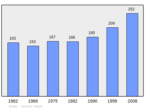
In 2010 the commune had 246 inhabitants. The evolution of the number of inhabitants is known from the population censuses conducted in the commune since 1793. From the 21st century, a census of communes with fewer than 10,000 inhabitants is held every five years, unlike larger towns that have a sample survey every year.[Note 1]
| 1793 | 1800 | 1806 | 1821 | 1831 | 1836 | 1841 | 1846 | 1851 |
|---|---|---|---|---|---|---|---|---|
| - | - | - | - | 317 | 351 | 330 | 352 | 340 |
| 1856 | 1861 | 1866 | 1872 | 1876 | 1881 | 1886 | 1891 | 1896 |
|---|---|---|---|---|---|---|---|---|
| 339 | 293 | 283 | 287 | 284 | 277 | 257 | 223 | 226 |
| 1901 | 1906 | 1911 | 1921 | 1926 | 1931 | 1936 | 1946 | 1954 |
|---|---|---|---|---|---|---|---|---|
| 227 | 231 | 219 | 189 | 176 | 179 | 184 | 182 | 179 |
| 1962 | 1968 | 1975 | 1982 | 1990 | 1999 | 2006 | 2010 | - |
|---|---|---|---|---|---|---|---|---|
| 163 | 153 | 167 | 166 | 180 | 209 | - | 246 | - |
Culture and heritage
.JPG)
Civil heritage
The commune has a number of buildings and structures that are registered as historical monuments:
Religious heritage
.JPG)
The commune has two religious buildings that are registered as historical monuments:
- The Parish Church of Saint-François-de-Sales (18th century) (destroyed)

- The Parish Church of Saint-François-de-Sales (1885).
- The furniture of the church

- A Chasuble (18th century)
- A Sun-ray Monstrance (19th century)
- 2 Altar Candlesticks (19th century)
- A Chalice (19th century)
- A Prie-dieu (19th century)
- A Stoup (19th century)
- 2 Altars, 4 altar seatings, and 2 Tabernacles (1885)
- An Altar, 2 altar seatings, a Tabernacle, and 2 Statues (1885)
- 3 Stained glass windows of people: Saint Francis de Sales, Saint Michael protecting a canon, and Saint John (1887)
- The furniture of the church
Facilities
Auriac has a primary school which also serves the communes of Garlède-Mondebat, Lalonquette et Miossens-Lanusse in an Educational Inter-communal Grouping.
See also
External links
- Community of communes of Luys en Béarn website (in French)
- Auriac on Lion1906
- Auriac on Géoportail, National Geographic Institute (IGN) website (in French)
- Auriac on the 1750 Cassini Map
Notes and references
Notes
- At the beginning of the 21st century, the methods of identification have been modified by Law No. 2002-276 of 27 February 2002 Archived 6 March 2016 at the Wayback Machine, the so-called "law of local democracy" and in particular Title V "census operations" allows, after a transitional period running from 2004 to 2008, the annual publication of the legal population of the different French administrative districts. For communes with a population greater than 10,000 inhabitants, a sample survey is conducted annually, the entire territory of these communes is taken into account at the end of the period of five years. The first "legal population" after 1999 under this new law came into force on 1 January 2009 and was based on the census of 2006.
References
- "Populations légales 2017". INSEE. Retrieved 6 January 2020.
- Inhabitants of Pyrénées-Atlantiques (in French)
- Google Maps
- Géoportail, IGN (in French)
- Ministry of Culture, Mérimée IA00026731 House at Cazaudehore (in French)
- Ministry of Culture, Mérimée IA00026732 House at Porte (in French)
- Michel Grosclaude, Toponymic Dictionary of communes, Béarn, Edicions reclams & Édition Cairn - 2006, 416 pages, ISBN 2-35068-005-3 (in French)
- Topographic Dictionary of the Department of Basses-Pyrenees, p. 17, Paul Raymond, Imprimerie nationale, 1863, Digitised from Lyon Public Library 15 June 2011 (in French)
- Cassini Map 1750 - Auriac
- Pierre de Marca, History of Béarn p. 356
- List of Mayors of France (in French)
- Ministry of Culture, Mérimée IA00026729 Houses and Farms (in French)
- Ministry of Culture, Mérimée IA00027931 Church of Saint-François-de-Sales (destroyed) (in French)
- Ministry of Culture, Mérimée IA00027930 Church of Saint-François-de-Sales (in French)
- Ministry of Culture, Palissy IM64001186 Furniture in the Church (in French)
- Ministry of Culture, Palissy IM64001185 Chasuble (in French)
- Ministry of Culture, Palissy IM64001184 Sun-ray Monstrance (in French)
- Ministry of Culture, Palissy IM64001183 2 Altar Candlesticks (in French)
- Ministry of Culture, Palissy IM64001182 Chalice (in French)
- Ministry of Culture, Palissy IM64001181 Prie-dieux (in French)
- Ministry of Culture, Palissy IM64001180 Stoup (in French)
- Ministry of Culture, Palissy IM64001179 2 Altars, 4 altar seatings, and 2 Tabernacles (in French)
- Ministry of Culture, Palissy IM64001178 Altar, 2 altar seatings, a Tabernacle, and 2 Statues (in French)
- Ministry of Culture, Palissy IM64001177 3 Stained glass windows of people: Saint Francis de Sales, Saint Michael protecting a canon, and Saint John (in French)
| Wikimedia Commons has media related to Auriac (Pyrénées-Atlantiques). |
| Authority control |
|
|---|