Andrein
Andrein is a French commune in the Pyrénées-Atlantiques department in the Nouvelle-Aquitaine region of south-western France.
Andrein | |
|---|---|
_Paysage_au-dessus_d'Andrein_et_de_la_vall%C3%A9e_de_la_Gave_d'Oloron.JPG) Landscape of Andrein and the Valley of the Gave d'Oloron | |
Location of Andrein 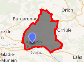
| |
 Andrein  Andrein | |
| Coordinates: 43°23′36″N 0°53′59″W | |
| Country | France |
| Region | Nouvelle-Aquitaine |
| Department | Pyrénées-Atlantiques |
| Arrondissement | Oloron-Sainte-Marie |
| Canton | Orthez et Terres des Gaves et du Sel |
| Intercommunality | Béarn des Gaves |
| Government | |
| • Mayor (2014-2020) | Alain Martin |
| Area 1 | 7.80 km2 (3.01 sq mi) |
| Population (2017-01-01)[1] | 131 |
| • Density | 17/km2 (43/sq mi) |
| Time zone | UTC+01:00 (CET) |
| • Summer (DST) | UTC+02:00 (CEST) |
| INSEE/Postal code | 64022 /64390 |
| Elevation | 57–221 m (187–725 ft) (avg. 74 m or 243 ft) |
| 1 French Land Register data, which excludes lakes, ponds, glaciers > 1 km2 (0.386 sq mi or 247 acres) and river estuaries. | |
The inhabitants of the commune are known as Andreinais or Andreinaises[2]
Geography
Location
Andrein is a béarnaise commune located on the left bank of the Gave d'Oloron 5 kilometres east of Sauveterre-de-Béarn and some 16 km south-west of Orthez. Access to the commune is by road D27 from Sauveterre-de-Bearn passing through the commune and the village and continuing east to Laàs. The D23 road from Burgaronne to L'Hôpital-d'Orion also passes through the north of the commune. The commune is mixed forest and farmland.[3]
Hydrography
Located in the Drainage basin of the Adour, the southern border of the commune is formed by the Gave d'Oloron. Numerous streams flow south through the commune to the Gave d'Oloron including the Malourau and the Lourou which forms the eastern border. The northern border is formed by the Arrec Heurre which flows west to eventually join the Gave d'Oleron east of Abitain.[3]
Localities and hamlets[4]
- Araspy[5]
- Arrouzère[5]
- Bachoué Château[5]
- Baillenx
- Balespet
- La Baronnie
- Bétouzet[5]
- Bonnemaison
- Bordenave (2 places)
- Braile
- Les Camous
- Casamayou
- Castagnède
- Casteret
- Charrie[5]
- Cousté
- Esploubet
- Hieyte
- Hourcade
- Hourquet
- Laborde
- Lagouarde
- Lauga[5]
- Lée
- Louhau
- Lourou
- Loustau
- Maysonnave
- Monplaisir
- Moulinau
- Pellou
- Pouyau
- Quartier de Pouyau
- La Salle[5]
- Sarrail
- Suberborde
- Temboury
- Téoulé
- Tinguerot
- Touroun.[5]
Neighbouring communes and villages[3]
Places adjacent to Andrein | |
|---|---|
Toponymy
The commune name in Béarnese dialect and in Gascon Occitan is Andrenh. Brigitte Jobbé-Duval[6] indicated that the name actually came from the family name Andréas with the suffix -enh. She also mentioned that the villagers were once called "cherry eaters".
The following table details the origins of the commune name and other names in the commune.
| Name | Spelling | Date | Source | Page | Origin | Description |
|---|---|---|---|---|---|---|
| Andrein | Andrenh | 1385 | Raymond | Census | Village | |
| Andreinh | 1544 | Raymond | Reformation | |||
| Sanctus Petrus d'Andrein | 1674 | Raymond | Insinuations | |||
| Araspy | Araspin | 1385 | Raymond | Census | Farm | |
| Araspin de haut | 1614 | Raymond | Reformation | |||
| Araspin de baig | 1614 | Raymond | Reformation | |||
| Arrouzère | Arrosere | 1385 | Raymond | Census | Farm | |
| Arrozere | 1391 | Raymond | Navarrenx | |||
| Bachoué | Bachoué | 1641 | Raymond | Reformation | Fief, vassal of the Viscounts of Béarn | |
| Bétouzet | Bétouzet | 1611 | Raymond | Fief, vassal of the Viscounts of Béarn | ||
| Carjuzan | Carjuzan | Raymond | Barony, subject to the Viscounts of Béarn | |||
| Charrie | L'ostau de Xarre | 1385 | Raymond | Census | Farm | |
| Charrie | 1614 | Raymond | Reformation | |||
| Charie | 1863 | Raymond | ||||
| Espiubeg | Espiubeig | 1780 | Raymond | Denombrement | Place | |
| Espiubeigt | 1780 | Raymond | Denombrement | |||
| Larsun | Larsuno | 1540 | Raymond | Reformation | Hamlet | |
| Lauga | Lauga | 1728 | Raymond | Denombrement | Fief, vassal of the Viscounts of Béarn | |
| Le Poey | Le Poey | 1863 | Raymond | Place | ||
| Sahores | Saƒores | 1397 | Raymond | Navarrenx | Farm | |
| La Salle | La Sale d'Andrenh | 1385 | Raymond | Census | Fief, vassal of the Viscounts of Béarn, subject to the bailiwick of Sauveterre | |
| La Sala d'Andrenh | 1538 | Raymond | Reformation | |||
| Touroun | La maison noble du Touron | 1728 | Raymond | Denombrement | Fief | |
| Le Turon | 1863 | Raymond |
Sources:
- Raymond: Topographic Dictionary of the Department of Basses-Pyrenees, 1863, on the page numbers indicated in the table. (in French)[5]
Origins:
History
Paul Raymond on page 6 of his 1863 dictionary noted that the commune had a Lay Abbey, a vassal of the Viscounts of Béarn.[5]
In 1385 Andrein reported 17 fires and depended on the bailiwick of Sauveterre.[5]
Administration
List of Successive Mayors[12]
| From | To | Name | Party | Position |
|---|---|---|---|---|
| 1995 | 2020 | Alain Martin |
(Not all data is known)
Inter-communality
The commune is part of five intercommunal structures:[13]
- the inter-communal centre for Social Action of Sauveterre-de-Béarn;
- the community of communes of Sauveterre-de-Béarn;
- the inter-communal association for the gaves and of Saleys;
- the AEP association for the Saleys region;
- the energy association for Pyrénées-Atlantiques
Demography
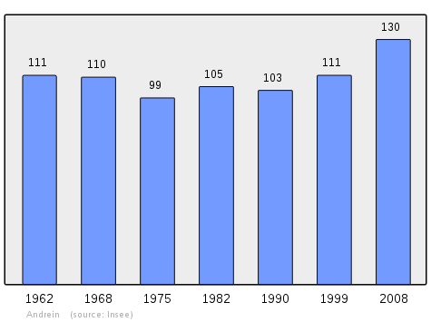
In 2009 the commune had 132 inhabitants. The evolution of the number of inhabitants is known through the population censuses conducted in the commune since 1793. From the 21st century, a census of communes with fewer than 10,000 inhabitants is held every five years, unlike larger towns that have a sample survey every year.[Note 1]
| 1793 | 1800 | 1806 | 1821 | 1831 | 1836 | 1841 | 1846 | 1851 |
|---|---|---|---|---|---|---|---|---|
| 378 | 238 | 402 | 271 | 286 | 373 | 372 | 364 | 331 |
| 1856 | 1861 | 1866 | 1872 | 1876 | 1881 | 1886 | 1891 | 1896 |
|---|---|---|---|---|---|---|---|---|
| 327 | 325 | 332 | 289 | 275 | 278 | 242 | 236 | 248 |
| 1901 | 1906 | 1911 | 1921 | 1926 | 1931 | 1936 | 1946 | 1954 |
|---|---|---|---|---|---|---|---|---|
| 268 | 246 | 231 | 218 | 212 | 210 | 214 | 184 | 142 |
| 1962 | 1968 | 1975 | 1982 | 1990 | 1999 | 2006 | 2009 | - |
|---|---|---|---|---|---|---|---|---|
| 111 | 110 | 99 | 105 | 103 | 111 | 123 | 132 | - |
Economy
Economic activity is mainly agricultural. The town is part of the Appellation d'origine contrôlée (AOC) zone of Ossau-iraty.
Culture and Heritage
Environmental heritage
The Touron de Larochelle is 195 metres high.[4]
Notable people linked to the commune
- Emmanuel Berl, born 2 August 1892 in Vésinet (Seine-et-Oise) and died 21 September 1976 in Paris, was a journalist, historian and French essayist. In 1920 he married Jacqueline Bordes in Andrein.
- Arthur Hugenschmidt (1862-1929) stayed in Andein in 1928 and 1929 with the Countess of Viforano (daughter of Dr. Joseph Marie Alfred Beni-Barde) according to correspondence from the Presidency of the Republic.
See also
External links
- Andrein on Lion1906
- Andrein on Géoportail, National Geographic Institute (IGN) website (in French)
- Andrein on the 1750 Cassini Map
Notes and references
Notes
- At the beginning of the 21st century, the methods of identification have been modified by law No. 2002-276 of 27 February 2002 Archived 2016-03-06 at the Wayback Machine, the so-called "law of local democracy" and in particular Title V "census operations" which allow, after a transitional period running from 2004 to 2008, the annual publication of the legal population of the different French administrative districts. For communes with a population greater than 10,000 inhabitants, a sample survey is conducted annually, the entire territory of these communes is taken into account at the end of the period of five years. The first "legal population" after 1999 under this new law came into force on 1 January 2009 and was based on the census of 2006.
References
- "Populations légales 2017". INSEE. Retrieved 6 January 2020.
- Inhabitants of Pyrénées-Atlantiques (in French)
- Google Maps
- Géoportail, IGN (in French)
- Topographic Dictionary of the Department of Basses-Pyrenees, Paul Raymond, Imprimerie nationale, 1863, Digitised from Lyon Public Library 15 June 2011 (in French)
- Brigitte Jobbé-Duval, Dictionary of placenames - Pyrénées-Atlantiques, 2009, Archives and Culture, ISBN 978-2-35077-151-9 (in French)
- Manuscript from the 14th century - Departmental Archives of Pyrénées-Atlantiques (in French)
- Manuscript from the 16th to 18th centuries - Departmental Archives of Pyrénées-Atlantiques (in French)
- Manuscripts from the 17th century in the Departmental Archives of Pyrénées-Atlantiques (in French)
- Manuscripts from the 17th and 18th centuries in the Departmental Archives of Pyrénées-Atlantiques (in French)
- List of Mayors of France
- Intercommunality of Pyrénées-Atlantiques Archived 2013-12-12 at the Wayback Machine, Cellule informatique préfecture 64, consulted on 9 November 2011 (in French)
| Wikimedia Commons has media related to Andrein. |
| Authority control |
|
|---|