Arbus, Pyrénées-Atlantiques
Arbus (Arbús in Occitan) is a commune in the Pyrénées-Atlantiques department in the Nouvelle-Aquitaine region of southwestern France.
Arbus | |
|---|---|
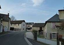
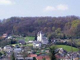 Arbus Village | |
Location of Arbus 
| |
 Arbus 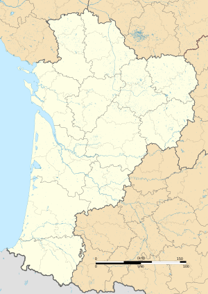 Arbus | |
| Coordinates: 43°20′03″N 0°30′17″W | |
| Country | France |
| Region | Nouvelle-Aquitaine |
| Department | Pyrénées-Atlantiques |
| Arrondissement | Pau |
| Canton | Lescar, Gave et Terres du Pont-Long |
| Intercommunality | CA Pau Béarn Pyrénées |
| Government | |
| • Mayor (2008–2020) | Didier Larrieu |
| Area 1 | 13.89 km2 (5.36 sq mi) |
| Population (2017-01-01)[1] | 1,205 |
| • Density | 87/km2 (220/sq mi) |
| Time zone | UTC+01:00 (CET) |
| • Summer (DST) | UTC+02:00 (CEST) |
| INSEE/Postal code | 64037 /64230 |
| Elevation | 125–284 m (410–932 ft) (avg. 144 m or 472 ft) |
| 1 French Land Register data, which excludes lakes, ponds, glaciers > 1 km2 (0.386 sq mi or 247 acres) and river estuaries. | |
The inhabitants of the commune are known as Arbusiens or Arbusiennes[2]
Geography
Arbus is located in the urban area of Pau 15 km to the north-west of the city and some 35 km south-east of Orthez mostly on the south bank of the Gave de Pau. Access to the commune is on the D2 road from Laroin in the south-east passing through the north of the commune to Abos in the north-west. Access to the village is by the D804 running off the D2 in the commune and continuing to Artiguelouve in the south-east and also by the D229 from the village to Parbayse in the south-west. The commune is mixed forest and farmland with large forests in the west, south, and south-east.[3]
Located in the Drainage basin of the Adour, the Gave de Pau flows through the northern part of the commune with some of its tributaries flowing through the rest of the commune: the Juscle and Baise Lasseube, as well as their tributaries, the Sibé stream, and the old Canal du Moulin which is itself joined in the commune by the Arrious stream.
Historical places and hamlets[4]
- Alicq[5]
- Barraqué
- Barrère
- Bédat
- Bellocq
- Berduc
- Bert
- Biscar
- Bordes
- Candau
- Cap d'Arrandes
- Castaing
- Castéra
- Catroui
- Chigé
- Croutzé
- Fages
- Ferrou
- Gaurrat
- Laborde
- Labourdette
- Lacroix
- Lagré
- Lahitte
- Lalanne
- Laplace
- Larribot
- Larrieste
- Laugary
- Manciet
- Monget
- Mounes
- Parisot
- Pé de Lahore
- Peyrounet
- Pommé
- Priou
- Ramonteu
- Rauly
- Saint-Sorque
- Sarthou
- Serviau
- Sibé[5]
- Sibers
- Tourangé
- Les Tourne-Brides
- Tuheil
- Vigneau
Neighbouring communes and villages[3]
Places adjacent to Arbus, Pyrénées-Atlantiques | |
|---|---|
Toponymy
The commune name in béarnais is Arbús (according to the classical norm of Occitan). According to Michel Grosclaude,[6] there is an aquitane root *arb-, meaning "grass" (close to alpe), and a collective suffix -untz giving a meaning of "a place where there is grass".
The following table details the origins of the commune name and other names in the commune.
| Name | Spelling | Date | Source | Page | Origin | Description |
|---|---|---|---|---|---|---|
| Arbus | Arbus | 1170 | Raymond | Barcelona | Village | |
| Arbuus | 1307 | Raymond | Orthez | |||
| Arbus | 1385 | Grosclaude | Census | |||
| Arbus | 1750 | Cassini | ||||
| Alicq | Alicq | 1863 | Raymond | Farm | ||
| Loubagnon | Looubagnon | 1775 | Raymond | Terrier | Place | |
| Saint-Mamet | Saint-Mamet | 1863 | Raymond | Place | ||
| Sibé | Le Ruisseau de Sibe | 1863 | Raymond | Stream, tributary of the Baïse de Lasseube |
Sources:
- Raymond: Topographic Dictionary of the Department of Basses-Pyrenees, 1863, on the page numbers indicated in the table. (in French)[5]
- Grosclaude: Toponymic Dictionary of communes, Béarn, 2006 (in French)[6]
- Cassini: Cassini Map from 1750[7]
Origins:
History
Paul Raymond on page 5 of his 1863 dictionary noted that in 1385 Arbus had 40 fires and depended on the bailiwick of Pau. The town was a dependency of the Marquisate of Gassion.[5]
Administration
List of Successive Mayors[12]
| From | To | Name | Party | Position |
|---|---|---|---|---|
| 1995 | 2020 | Didier Larrieu |
(Not all data is known)
Inter-communality
The commune of Arbus is part of eight inter-communal structures:
- the Community of communes of Miey de Béarn;
- the SIVU for the management and development of the watercourses in the Baïses basin;
- the SIVU for aged and infirm services for the Canton of Lescar;
- the AEP association for Gave and Baïse;
- the association for the management of the banks of the Juscle and its tributaries;
- the association for sanitation of the communes in the valleys of the Juscle and the Baïse;
- the Energy association for Pyrénées-Atlantiques ;
- the inter-communal syndicate for defence against floods of the Gave de Pau.
Demography
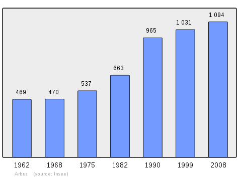
In 2009 the commune had 1,098 inhabitants. The evolution of the number of inhabitants is known from the population censuses conducted in the commune since 1793. From the 21st century, a census of communes with fewer than 10,000 inhabitants is held every five years, unlike larger towns that have a sample survey every year.[Note 1]
| 1793 | 1800 | 1806 | 1821 | 1831 | 1836 | 1841 | 1846 | 1851 |
|---|---|---|---|---|---|---|---|---|
| 75 | 673 | 663 | 751 | 869 | 847 | 837 | 900 | 841 |
| 1856 | 1861 | 1866 | 1872 | 1876 | 1881 | 1886 | 1891 | 1896 |
|---|---|---|---|---|---|---|---|---|
| 823 | 776 | 765 | 730 | 758 | 712 | 700 | 636 | 637 |
| 1901 | 1906 | 1911 | 1921 | 1926 | 1931 | 1936 | 1946 | 1954 |
|---|---|---|---|---|---|---|---|---|
| 637 | 614 | 582 | 568 | 499 | 494 | 507 | 445 | 415 |
| 1962 | 1968 | 1975 | 1982 | 1990 | 1999 | 2006 | 2009 | - |
|---|---|---|---|---|---|---|---|---|
| 469 | 470 | 537 | 663 | 965 | 1,031 | 1,076 | 1,098 | - |
Economy
The commune is part of the Appellation d'origine contrôlée (AOC) zone of Winemakers of Jurançon and of Béarn and partially in the AOC zone for Ossau-iraty.
Culture and Heritage
Religious Heritage
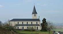
The Parish Church of Saint-Mamer (1868)![]()
Amenities
Education
The town has a primary school.[14]
Notable people linked to the commune
- Arnaud II of Arbus[15] (or Arnaldus of Arbouze[16]) from 1303[17] to 1320[18] was Bishop of Lescar.
- Pommiès André, born in 1904 at Bordeaux and died in 1972 at Arbus was a French military Hero of the Resistance.
- Georges Lapassade, born in 1924 at Arbus and died in 2008 at Stains, was a philosopher and French sociologist.
See also
External links
- Arbus official website (in French)
- Community of communes of Miey de Béarn website Arbus page (in French)
- Arbus on Lion1906
- Arbus on Géoportail, National Geographic Institute (IGN) website (in French)
- Arbus on the 1750 Cassini Map
Notes and references
Notes
- At the beginning of the 21st century, the methods of identification have been modified by Law No. 2002-276 of 27 February 2002 Archived 6 March 2016 at the Wayback Machine, the so-called "law of local democracy" and in particular Title V "census operations" allows, after a transitional period running from 2004 to 2008, the annual publication of the legal population of the different French administrative districts. For communes with a population greater than 10,000 inhabitants, a sample survey is conducted annually, the entire territory of these communes is taken into account at the end of the period of five years. The first "legal population" after 1999 under this new law came into force on 1 January 2009 and was based on the census of 2006.
References
- "Populations légales 2017". INSEE. Retrieved 6 January 2020.
- Inhabitants of Pyrénées-Atlantiques (in French)
- Google Maps
- Géoportail, IGN (in French)
- Topographic Dictionary of the Department of Basses-Pyrenees, Paul Raymond, Imprimerie nationale, 1863, Digitised from Lyon Public Library 15 June 2011 (in French)
- Michel Grosclaude, Toponymic Dictionary of communes, Béarn, Edicions reclams & Édition Cairn - 2006, 416 pages, ISBN 2-35068-005-3 (in French)
- Cassini Map 1750 – Arbus
- Titles published in the proofs of the History of Béarn by Pierre de Marca (in French)
- Cartulary of Orthez called Martinet, manuscript from the 14th to the 17th centuries in the Archives of the Orthez town hall (in French)
- Manuscript from the 14th century - Departmental Archives of Pyrénées-Atlantiques (in French)
- Manuscript from the 18th century in the Departmental Archives of Pyrénées-Atlantiques (in French)
- List of Mayors of France
- Ministry of Culture, Mérimée IA64000554 Parish Church of Saint-Mamer (in French)
- The Arbus School on the commune website (in French)
- Nominal spelling given by La Grande Encyclopédie
- Nominal spelling given by the Trésor de Chronologie(in French)
- Date given by La Grande Encyclopédie and the Trésor de Chronologie
- Date given by La Grande Encyclopédie
| Wikimedia Commons has media related to Arbus. |
| Authority control |
|
|---|