Anos, Pyrénées-Atlantiques
Anos is a commune in the Pyrénées-Atlantiques department in the Nouvelle-Aquitaine region of southwestern France.
Anos | |
|---|---|
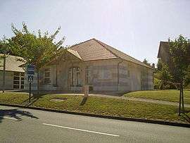 Town hall | |
Location of Anos 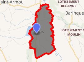
| |
 Anos  Anos | |
| Coordinates: 43°23′57″N 0°17′29″W | |
| Country | France |
| Region | Nouvelle-Aquitaine |
| Department | Pyrénées-Atlantiques |
| Arrondissement | Pau |
| Canton | Pays de Morlaàs et du Montanérès |
| Intercommunality | Pays de Morlaàs |
| Government | |
| • Mayor (2014–2020) | Christelle Desclaux |
| Area 1 | 1.79 km2 (0.69 sq mi) |
| Population (2017-01-01)[1] | 192 |
| • Density | 110/km2 (280/sq mi) |
| Time zone | UTC+01:00 (CET) |
| • Summer (DST) | UTC+02:00 (CEST) |
| INSEE/Postal code | 64027 /64160 |
| Elevation | 199–305 m (653–1,001 ft) (avg. 250 m or 820 ft) |
| 1 French Land Register data, which excludes lakes, ponds, glaciers > 1 km2 (0.386 sq mi or 247 acres) and river estuaries. | |
The inhabitants of the commune are known as Anosiens or Anosiennes[2]
Geography
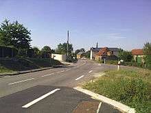
Anos is located some 15 km north-east of Pau and 10 km south-east of Auriac. Access to the commune is by road D39 from Morlaas in the south passing north through the commune and the village and continuing north to join the D834 just north of Astis. Several other country roads also pass through the commune.
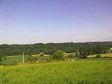
The Lau river forms the western border of the commune with the eastern shore of the Lake of Saint-Amour (also called the Lake of Anos) forming the part just west of the village. The Lau flows north to join the Luy de France which also forms the eastern border of the commune.[3]
Toponymy
The commune name in Béarnais is Anòs (according to the classical norm of Occitan).
Brigitte Jobbé-Duval[7] indicates that Anos could be of Gallic origin being the name of the property owner Andus plus the suffix -ossu with a proposed meaning of "Domain of Andus".
The name Anos was mentioned in 1243[8] in the Titles of Ossau[9] and in the Cassini map in 1750[10]).
History
Paul Raymond[8] noted on page 6 of the 1863 dictionary that in the 14th century Anos belonged to the community of Preachers of Morlaàs.
The commune was part of the archdeaconry of Vic-Bihl which depended on the diocese of Lescar of which Lembeye was the capital.[8]
Administration
List of Successive Mayors[11]
| From | To | Name | Party | Position |
|---|---|---|---|---|
| 1995 | 2008 | Jacques Cantonnet | ||
| 2008 | 2014 | Patrick Yacger | ||
| 2014 | 2020 | Christelle Desclaux |
(Not all data is known)
Inter-communality
Anos is part of five inter-communal structures:[12]
- The Community of communes of Pays de Morlaàs;
- The SIVU for the maintenance of roads, parks and buildings in Barinque;
- The AEP association for the Regions of Luy and Gabas;
- The Energy association of Pyrénées-Atlantiques;
- The iner-communal association for irrigation of Anos - Saint-Armou.
Demography
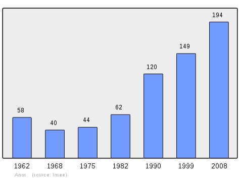
In 2009 the commune had 193 inhabitants. The evolution of the number of inhabitants is known from the population censuses conducted in the commune since 1793. From the 21st century, a census of communes with fewer than 10,000 inhabitants is held every five years, unlike larger towns that have a sample survey every year.[Note 1]
|
|
|
Anos is part of the Urban area of Pau.
Culture and Heritage
Civil heritage
Religious heritage
- The Parish Church of Saint-Laurent (11th century)

Environmental heritage
An artificial lake called Lake Saint-Armou or Lake of Anos[4] is on the border between the two communes.
Notes and references
Notes
- At the beginning of the 21st century, the methods of identification have been modified by Law No. 2002-276 of 27 February 2002 Archived 6 March 2016 at the Wayback Machine, the so-called "law of local democracy" and in particular Title V "census operations" allows, after a transitional period running from 2004 to 2008, the annual publication of the legal population of the different French administrative districts. For communes with a population greater than 10,000 inhabitants, a sample survey is conducted annually, the entire territory of these communes is taken into account at the end of the period of five years. The first "legal population" after 1999 under this new law came into force on 1 January 2009 and was based on the census of 2006.
References
- "Populations légales 2017". INSEE. Retrieved 6 January 2020.
- Inhabitants of Pyrénées-Atlantiques (in French)
- Google Maps
- Géoportail, IGN, consulted on 25 November 2011 (in French)
- Ministry of Culture, Mérimée IA00026891 Maison Tachoères farmhouse (in French)
- Michel Grosclaude, Toponymic Dictionary of communes, Béarn, Edicions reclams & Édition Cairn, 2006, ISBN 2 35068 005 3 (in French)
- Brigitte Jobbé-Duval, Dictionary of Place Names - Pyrénées-Atlantiques, 2009, Archives and Culture, ISBN 978-2-35077-151-9 (in French)
- Topographic Dictionary of the Department of Basses-Pyrenees, Paul Raymond, Imprimerie nationale, 1863, Digitised from Lyon Public Library 15 June 2011 (in French)
- Titles of the Ossau Valley - Departmental archives of Pyrénées-Atlantiques
- Cassini Map 1750 - Anos
- List of Mayors of France
- Intercommunality of Pyrénées-Atlantiques, Cellule informatique préfecture 64, consulted on 25 November 2011 (in French)
- Ministry of Culture, Mérimée IA00026890 Houses and Farms (in French)
- Ministry of Culture, Mérimée IA00026892 Parish Church of Saint-Laurent (in French)
| Wikimedia Commons has media related to Anos. |
External links
- Anos on Lion1906
- Anos on Géoportail, National Geographic Institute (IGN) website (in French)
- Anos on the 1750 Cassini Map
Places adjacent to Anos, Pyrénées-Atlantiques | |
|---|---|
| Authority control |
|
|---|