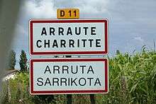
Arraute-Charritte
Arraute-Charritte (Basque: Arrueta-Sarrikota) is a commune in the Pyrénées-Atlantiques department in the Nouvelle-Aquitaine region of south-western France.
Arraute-Charritte Arrueta-Sarrikota | |
|---|---|
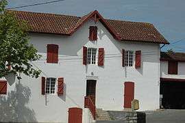 The Bakery | |
.svg.png) Coat of arms | |
Location of Arraute-Charritte 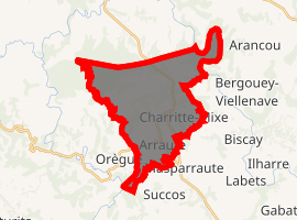
| |
 Arraute-Charritte  Arraute-Charritte | |
| Coordinates: 43°23′59″N 1°06′20″W | |
| Country | France |
| Region | Nouvelle-Aquitaine |
| Department | Pyrénées-Atlantiques |
| Arrondissement | Bayonne |
| Canton | Pays de Bidache, Amikuze et Ostibarre |
| Intercommunality | CA Pays Basque |
| Government | |
| • Mayor (2014-2020) | Christian Guillemin |
| Area 1 | 22.81 km2 (8.81 sq mi) |
| Population (2017-01-01)[1] | 385 |
| • Density | 17/km2 (44/sq mi) |
| Time zone | UTC+01:00 (CET) |
| • Summer (DST) | UTC+02:00 (CEST) |
| INSEE/Postal code | 64051 /64120 |
| Elevation | 8–192 m (26–630 ft) (avg. 60 m or 200 ft) |
| 1 French Land Register data, which excludes lakes, ponds, glaciers > 1 km2 (0.386 sq mi or 247 acres) and river estuaries. | |
Geography
Arraute-Charritte is located in the former province of Lower Navarre some 40 km east by south-east of Bayonne and 15 km north-west of Saint-Palais. Access to the commune is by the D11 road from Bidache in the north passing through the commune east of the village and continuing to Masparraute in the south. Access to the village is by the D246 from Orègue in the west passing the village then south-west to Masparraute. The D313 also passes down the western border of the commune from the D11 south of Bidache and joins the D246 west of the village. The D310 goes east from the D11 north of the village to Bergouey-Viellenave. There are forests in the north-east and north-west of the commune with a band of patchy forest through the centre. The rest of the commune is farmland.[4]
There is a stop in the commune on bus route 870 from Tardets-Sorholus to Bayonne on the Interurban Network of Pyrénées-Atlantiques.
The Bidouze river forms the north-eastern border of the commune with the Ruisseau de Mandeheguy flowing into it there. Numerous other streams rise all over the commune and flow east to the Bidouze. The Ruiusseau de Bordaberry rises in the north of the commune and flows west to join the Apatharena which forms the western border of the commune and continues north to join the Lihoury. Numerous other streams rise in the commune and flow to the Apatharena.[4]
Places and Hamlets[5]
- Ameztoya
- Ansobieta
- Aphatepe
- Aphatiague
- Arraute
- Ascoundreguy
- Atchuquia
- Ayenia
- Baratchartia
- Barneto
- Beigtanborda
- Bellevue
- Bellereta
- Bentaberry
- Bertranteguia
- Biscaborda
- Biscagoitia
- Biscaya
- Bissargorry
- Bordaberry
- Bordakoborda
- Bousquets
- Camoussarria
- Charritte
- Charrittounia
- Chilocoa
- Costenenia
- Elhordoy
- Elizondokoborda
- Ermit
- Ermitaborda
- Etchari
- Etchebestia
- Etchemendikoborda
- Etchemendy
- Ithurrongarat
- Fitounia
- Galharreta
- Garatia
- Garaya
- Goihenech
- Grachigno
- Harria
- Héguia
- Iratchet
- Iriatia
- Iribarnia
- Jauregia
- Labenta
- Larralde-Borda
- Borde Larralde
- Larraldia (two places)
- Laxague (ruins)
- Mandio
- Mendiburia
- Manéchans (ruins)
- Millafranque
- Miquelet
- Olheguy
- Oquelargainia
- Othaburia
- Oxobia
- Oyhanburia
- Oyhenart
- Oyhenartia
- Patatouch
- Phagoa
- Borde dou Rey
- Saharcet
- Santacoits
- Sarrailh
- Sorhigarat
- Sorhigaratborda
- Souquirats
- Trouilh
- Urrutia
Neighbouring communes and villages[4] | |
|---|---|
.jpg)
Toponymy
The commune name in basque is Arrueta-Sarrikota.[3]
Jean-Baptiste Orpustan[6] indicated that Charrite came from Sarri-ko-(e)ta meaning "place of small bushes". However, there is no certainty of the origin of the name Arraute.
The following table details the origins of the commune name and other names in the commune.
| Name | Spelling | Date | Source | Page | Origin | Description |
|---|---|---|---|---|---|---|
| Arraute | Arraute | 1125 | Orpustan | Village | ||
| Sanctus petrus de arraute | 1160 | Orpustan | ||||
| Arrauta | 13th century | Raymond | Duchesne | |||
| Araute | 1350 | Orpustan | ||||
| Arraute | 1413 | Orpustan | ||||
| Arrauta | 1513 | Raymond | Pamplona | |||
| Arruela | 1621 | Raymond | Biscay | |||
| Charritte | Sanctus Joannes de Sarricte | 1160 | Orpustan | Village | ||
| Sarrite | 1316 | Orpustan | ||||
| Ssarriette | 1381 | Orpustan | ||||
| Sarrk oete | 1413 | Orpustan | ||||
| Sarricoata | 1513 | Raymond | Pamplona | |||
| Charrite | 1750 | Cassini | ||||
| Charrite | 1801 | Ldh/EHESS/Cassini | Bulletin des Lois | |||
| Le Coud | Le Coud | 1863 | Raymond | Wood | ||
| Éliçaïcine | Éliçaïcine | 1863 | Raymond | Fief of the Kingdom of Navarre | ||
| Élicetche | Élicetche | 1863 | Raymond | Fief of the Kingdom of Navarre | ||
| Chemin de l'Ermite | Chemin de l'Ermite | 1863 | Raymond | |||
| Ithorrondo | Yturrondo | 1621 | Raymond | Biscay | Farm |
Sources:
- Raymond: Topographic Dictionary of the Department of Basses-Pyrenees, 1863, on the page numbers indicated in the table. (in French)[7]
- Orpustan: Jean-Baptiste Orpustan, New Basque Toponymy[6]
- Cassini: Cassini Map from 1750[8]
- Ldh/EHESS/Cassini: Charritte on the Ldh/EHESS/Cassini database (in French)
Origins:
History
The commune of Arraute and its village, Charritte-Mixe, were merged on 27 June 1842.[7]
Administration
List of Successive Mayors[13]
| From | To | Name | Party | Position |
|---|---|---|---|---|
| 1995 | 2001 | Robert Gratien | CEO | |
| 2001 | 2014 | Christian Guillemin | Driver |
(Not all data is known)
Inter-communality
The commune is part of five inter-communal structures:
- the AEP association of Pays de Mixe;
- the educational regrouping association of Amorots-Succos, Arraute-Charritte, Beguios, Masparraute, and Orègue;
- the Energy association of Pyrénées-Atlantiques;
- the inter-communal association for the functioning of schools in Amikuze;
- the association to support Basque culture.
Demography
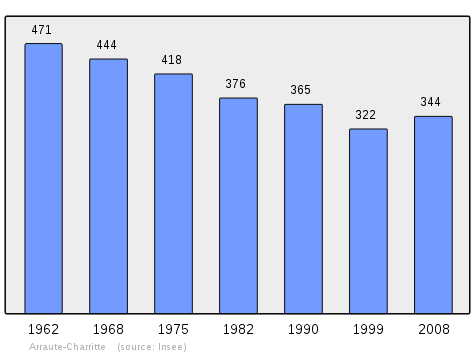
In 2009 the commune had 365 inhabitants. The evolution of the number of inhabitants is known from the population censuses conducted in the commune since 1793. From the 21st century, a census of communes with fewer than 10,000 inhabitants is held every five years, unlike larger towns that have a sample survey every year.[Note 1]
| 1793 | 1800 | 1806 | 1821 | 1831 | 1836 | 1841 | 1846 | 1851 |
|---|---|---|---|---|---|---|---|---|
| 536 | 410 | 520 | 695 | 762 | 769 | 737 | 735 | 713 |
| 1856 | 1861 | 1866 | 1872 | 1876 | 1881 | 1886 | 1891 | 1896 |
|---|---|---|---|---|---|---|---|---|
| 686 | 721 | 720 | 712 | 713 | 731 | 657 | 634 | 612 |
| 1901 | 1906 | 1911 | 1921 | 1926 | 1931 | 1936 | 1946 | 1954 |
|---|---|---|---|---|---|---|---|---|
| 662 | 664 | 644 | 555 | 535 | 573 | 558 | 506 | 461 |
| 1962 | 1968 | 1975 | 1982 | 1990 | 1999 | 2006 | 2009 | - |
|---|---|---|---|---|---|---|---|---|
| 471 | 444 | 418 | 376 | 365 | 322 | 322 | 365 | - |
Distribution of Age Groups
Percentage Distribution of Age Groups in Arraute-Charritte and Charente-Maritime Department in 2009
| Arraute-Charritte | Arraute-Charritte | Pyrénées-Atlantiques | Pyrénées-Atlantiques | |
|---|---|---|---|---|
| Age Range | Men | Women | Men | Women |
| 0 to 14 Years | 12.9 | 18.0 | 17.4 | 15.2 |
| 15 to 29 Years | 13.4 | 10.9 | 17.5 | 15.4 |
| 30 to 44 Years | 25.2 | 18.6 | 20.1 | 19.0 |
| 45 to 59 Years | 23.3 | 19.1 | 21.3 | 20.8 |
| 60 to 74 Years | 18.3 | 19.7 | 15.1 | 16.2 |
| 75 to 89 Years | 6.9 | 12.0 | 8.1 | 11.9 |
| 90 Years+ | 0.0 | 1.6 | 0.5 | 1.5 |
Sources:
Economy
The town is part of the Appellation d'origine contrôlée (AOC) zone designation of Ossau-iraty.
Budget and Taxation
- Dwelling Tax: 9.04% (2003)[14]
- Property tax: 6.39% (built properties)
- Business Tax: 7.97%
The local economy is mainly based on agriculture:
Culture and Heritage
Civil heritage
The village is typically Basque and has some Maisons à colombages (timbered houses).
Religious heritage
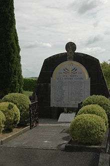
.jpg)
- The Parish Church of Saint-Pierre in Arraute (19th century)

- The Funeral Chapel of Samacoitz is also part of the religious heritage.
Environmental heritage
The Banks of the Bidouze are classified as a Natura 2000 site.[16]
Education
Amorots-Succos, Masparraute, Orègue, Béguios, and Arraute-Charritte have created together an inter-communal educational grouping (R.P.I. AMOBA[17]).
See also
External links
Notes and references
Notes
- At the beginning of the 21st century, the methods of identification have been modified by Law No. 2002-276 of 27 February 2002 Archived 6 March 2016 at the Wayback Machine, the so-called "law of local democracy" and in particular Title V "census operations" allows, after a transitional period running from 2004 to 2008, the annual publication of the legal population of the different French administrative districts. For communes with a population greater than 10,000 inhabitants, a sample survey is conducted annually, the entire territory of these communes is taken into account at the end of the period of five years. The first "legal population" after 1999 under this new law came into force on 1 January 2009 and was based on the census of 2006.
References
- "Populations légales 2017". INSEE. Retrieved 6 January 2020.
- Brigitte Jobbé-Duval, Dictionary of place names - Pyrénées-Atlantiques, 2009, Archives and Culture, ISBN 978-2-35077-151-9 (in French)
- Euskaltzaindia - Academy of the Basque language (in French)
- Google Maps
- Géoportail, IGN (in French)
- Jean-Baptiste Orpustan, New Basque Toponymy, Presses universitaires de Bordeaux, 2006, ISBN 2 86781 396 4 (in French)
- Topographic Dictionary of the Department of Basses-Pyrenees, Paul Raymond, Imprimerie nationale, 1863, Digitised from Lyon Public Library 15 June 2011 (in French)
- Cassini Map 1750 – Charrite
- Duchesne Collection, volumes 99 to 114, containing the papers of Oihenart, former Imperial Librarian - Bibliothèque nationale de France
- Titles published by don José Yanguas y Miranda (in Spanish)
- Derecho de naturaleza que la merindad de San-Juan-del-pie-del-puerto, una de las seys de Navarra, tiene en Castilla, 1622 (in Spanish)
- Guy Ascarat Archived November 9, 2013, at the Wayback Machine (in French)
- List of Mayors of France (in French)
- Official website of the General Directorate of Taxation Archived 2016-03-03 at the Wayback Machine (in French)
- Ministry of Culture, Mérimée IA64000686 Parish Church of Saint-Pierre (in French)
- The Bidouze on Natura 2000 (in French)
- R.P.I. AMOBA website (in French)
| Wikimedia Commons has media related to Arraute-Charritte. |
| Authority control |
|
|---|