Agnos
Agnos is a French commune in the Pyrénées-Atlantiques department in the Nouvelle-Aquitaine region in southwestern France.
Agnos | |
|---|---|
_La_Mielle.JPG) The Mielle at Agnos | |
Location of Agnos 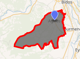
| |
 Agnos  Agnos | |
| Coordinates: 43°09′50″N 0°37′05″W | |
| Country | France |
| Region | Nouvelle-Aquitaine |
| Department | Pyrénées-Atlantiques |
| Arrondissement | Oloron-Sainte-Marie |
| Canton | Oloron-Sainte-Marie-1 |
| Intercommunality | Haut Béarn |
| Government | |
| • Mayor (2014-2020) | André Bernos |
| Area 1 | 9.18 km2 (3.54 sq mi) |
| Population (2017-01-01)[1] | 1,019 |
| • Density | 110/km2 (290/sq mi) |
| Time zone | UTC+01:00 (CET) |
| • Summer (DST) | UTC+02:00 (CEST) |
| INSEE/Postal code | 64007 /64400 |
| Elevation | 247–535 m (810–1,755 ft) (avg. 250 m or 820 ft) |
| 1 French Land Register data, which excludes lakes, ponds, glaciers > 1 km2 (0.386 sq mi or 247 acres) and river estuaries. | |
The inhabitants of the commune are known as Agnosiens or Agnosiennes[2]
_Porte_d'acc%C3%A8s_et_aper%C3%A7u_du_ch%C3%A2teau.JPG)
Geography
Agnos is located just 2 km south of Oloron-Sainte-Marie and some 25 km southwest of Pau. It can be accessed on the D155 road from Bidos in the northeast coming southwest to the village then continuing southeast to Gurmençon. The D555 road also passes through the commune from the north and joins the D155 northeast of the village.[3] The commune is mixed farmland and forests with the forests scattered throughout the commune.
Located in the Adour basin,[4] the Mielle river flows from south of the commune forming part of the southern border then continuing north through the village and together with several tributaries rising in the commune joins the Gave d'Oloron north of Oloron-Sainte-Marie.
Places and hamlets
- La Baig[5]
- Candalot
- Dufau
- Fontaine Anglade
- Laborde-Boy
- Lasserre
- Ledorré
- Logecoop
- Mirande
- Le Plouts
- Sayette
- Sentin
Neighbouring communes and villages
Places adjacent to Agnos | ||||||||||
|---|---|---|---|---|---|---|---|---|---|---|
| ||||||||||
Toponymy
The commune name in béarnais is Anhos. Michel Grosclaude suggested that Agnos came from a Latin man's name Annius with an Aqitaine suffix -ossum the whole meaning "domain of Annius".[6]
The following table details the origins of the commune name and other names in the commune.
| Name | Spelling | Date | Source | Page | Origin | Description |
|---|---|---|---|---|---|---|
| Agnos | Anhos | 1364 | Raymond | Fors de Béarn | Village | |
| Aynhos | 14th century | Raymond | Census | |||
| Aignos | 1675 | Raymond | Reformation | |||
| Agnos | 18th century | Grosclaude | ||||
| Agnos | 1750 | Cassini | ||||
| La Baig | La Baig | 1863 | Raymond | Forest |
Sources:
- Raymond: Topographic Dictionary of the Department of Basses-Pyrenees, 1863, on the page numbers indicated in the table. (in French)[5]
- Grosclaude: Toponymic Dictionary of communes, Béarn, 2006 (in French)[6]
- Cassini: Cassini Map from 1750[7]
Origins:
History
Paul Raymond noted on page 3 of his 1863 dictionary that in 1385 Agnos had seventeen fires and depended on the bailiwick of Oloron.[5]
The commune was merged with Gurmençon on 1 February 1973 to form the commune called Val-du-Gave d'Aspe. It was restored to its previous status on 1 January 1983.
Administration
List of Successive Mayors of Agnos[10]
| From | To | Name | Party | Position |
|---|---|---|---|---|
| 1995 | Current | André Bernos | PS |
(Not all data is known)
Inter-communality
The town is part of five inter-communal organisations:
- the Community of communes of Piedmont Oloronais
- the SIVU to limit floods in Agnos
- the AEP Union for Agnos-Gurmençon
- the Inter-communal Union for Sanitisation for the Aspe gateway
- the energy union for Pyrénées-Atlantiques
Population
| Year | Pop. | ±% |
|---|---|---|
| 2006 | 824 | — |
| 2007 | 834 | +1.2% |
| 2008 | 842 | +1.0% |
| 2009 | 864 | +2.6% |
| 2010 | 880 | +1.9% |
| 2011 | 895 | +1.7% |
| 2012 | 910 | +1.7% |
| 2013 | 929 | +2.1% |
| 2014 | 966 | +4.0% |
| 2015 | 984 | +1.9% |
| 2016 | 1,001 | +1.7% |
| 1793 | 1800 | 1806 | 1821 | 1831 | 1836 | 1841 | 1846 | 1851 |
|---|---|---|---|---|---|---|---|---|
| 346 | 301 | 328 | 375 | 421 | 479 | 473 | 482 | 461 |
| 1856 | 1861 | 1866 | 1872 | 1876 | 1881 | 1886 | 1891 | 1896 |
|---|---|---|---|---|---|---|---|---|
| 431 | 431 | 419 | 407 | 372 | 402 | 384 | 405 | 405 |
| 1901 | 1906 | 1911 | 1921 | 1926 | 1931 | 1936 | 1946 | 1954 |
|---|---|---|---|---|---|---|---|---|
| 412 | 406 | 403 | 401 | 374 | 373 | 368 | 351 | 390 |
| 1962 | 1968 | 1975 | 1982 | 1990 | 1999 | 2006 | 2007 | 2008 |
|---|---|---|---|---|---|---|---|---|
| 372 | 353 | 465 | 478 | 645 | 751 | 824 | 834 | 842 |
| 2009 | 2010 | - | - | - | - | - | - | - |
|---|---|---|---|---|---|---|---|---|
| 864 | 880 | - | - | - | - | - | - | - |
Agnos is part of the urban area of Oloron-Sainte-Marie.
Economy
The activity of the commune is mainly agricultural (farming, polyculture). The town is part of the Appellation d'origine contrôlée (AOC) of ossau-iraty.
The 2006 classification by INSEE showed the median household incomes for each commune with more than 50 households (30,687 communes out of 36,681 communes identified).[11] It classed Agnos at the rank of 6,323, for an average income of €18,420.
Culture and heritage
Religious Heritage
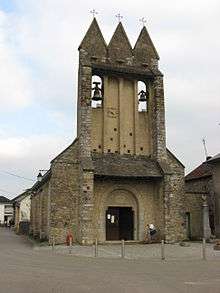
The Church has a Trinitarian steeple (the presence of a Bell-gable or campenard). It contains many items which are registered as historical objects (although some were destroyed by fire in 1968):
Environmental heritage
The Forests of Bugangue[19] and Labaigt are inter-association woods managed by the National Office of Forests (ONF)[20] which provide valuable shelter for preserving local flora and fauna. Many species are protected. An arboretum is a result of collaboration with the ONF.[21]
The Mielle, a small stream that rises in Agnos, is listed in the Natura 2000 program for three rare species: white-clawed crayfish, European pond turtles, and the rare European mink which does not exist anywhere in France except in the south-west.
The Pyrenees are rich in scenery and the village of Agnos is the starting point of one of the most attractive routes for cycling across the foothills: From Agnos to Mail Arrouil and back (four hours of cycling or seven hours of walking) in a variety of environments, moors, rocks, meadows with views of the Pyrenees. This route, like many others, is managed by the local hiking plan of the Community of communes of Piémont Oloronais (CCPO).[22]
Facilities
- Associations
The model aircraft club[23] welcomes its members in the Sayette neighborhood.
- Education
The town has a primary school.
- Multi-Media Library
The Multi-media library project of the CCPO identified the municipal library of Agnos as a relay point.
- Sports and sports equipment
The basketball club merged with that of Asasp in 2006 to form BCHB (Basketball Club of Haut-Bearn).
Notable People linked to the commune
- Catherine Capdevielle, born in 1938 in Agnos, is an athlete specialising in ordeal sprinting.
Notes
References
- "Populations légales 2017". INSEE. Retrieved 6 January 2020.
- Inhabitants of Pyrénées-Atlantiques (in French)
- Google Maps
- Notice of Sandre on Agnos Archived 2007-10-15 at the Wayback Machine, consulted on 27 September 2009 (in French)
- Topographic Dictionary of the Department of Basses-Pyrenees, Paul Raymond, Imprimerie nationale, 1863, Digitised from Lyon Public Library 15 June 2011 (in French)
- Michel Grosclaude, Toponymic Dictionary of communes, Béarn, Edicions reclams & Édition Cairn - 2006, 416 pages, ISBN 2-35068-005-3 (in French)
- Cassini Map 1750 – Agnos
- Manuscript from the 14th century - Departmental Archives of Pyrénées-Atlantiques (in French)
- Manuscript from the 16th to 18th centuries - Departmental Archives of Pyrénées-Atlantiques (in French)
- List of Mayors of France (in French)
- Statistical Summary by commune, department, and sector of employment Archived 2012-06-04 at Archive.today, consulted on 9 September 2009 (in French)
- Ministry of Culture, Palissy PM64000537 Altar (in French)
- Ministry of Culture, Palissy PM64000536 6 Candlesticks (in French)
- Ministry of Culture, Palissy PM64000535 Cross (in French)
- Ministry of Culture, Palissy PM64000534 Tabernacle (in French)
- Ministry of Culture, Palissy PM64000006 Chalice (in French)
- Ministry of Culture, Palissy PM64000005 Ciborium (in French)
- Ministry of Culture, Palissy PM64000003 Retable (in French)
- Friends of Bugangue website (in French)
- National Office of Forests website (in French)
- The arboretum is mentioned on the commune website (in French)
- CCPO website (in French)
- Model Aircraft Club website (in French)
External links
- Agnos Town Hall website (in French)
- Agnos official website (in French)
- Community of communes of Piémont oloronais website (in French)
- Agnos on Lion1906
- Agnos on the 1750 Cassini Map
| Wikimedia Commons has media related to Agnos. |
| Authority control |
|
|---|