Arhansus
Arhansus (Basque: Arhantsusi) is a commune in the Pyrénées-Atlantiques department in the Nouvelle-Aquitaine region of south-western France.
Arhansus Arhantsusi | |
|---|---|
 Arhansus sign | |
Location of Arhansus 
| |
 Arhansus 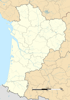 Arhansus | |
| Coordinates: 43°15′30″N 1°02′04″W | |
| Country | France |
| Region | Nouvelle-Aquitaine |
| Department | Pyrénées-Atlantiques |
| Arrondissement | Bayonne |
| Canton | Pays de Bidache, Amikuze et Ostibarre |
| Intercommunality | CA Pays Basque |
| Government | |
| • Mayor (2014-2020) | Christine Erdozaincy-Etchart |
| Area 1 | 5.32 km2 (2.05 sq mi) |
| Population (2017-01-01)[1] | 74 |
| • Density | 14/km2 (36/sq mi) |
| Time zone | UTC+01:00 (CET) |
| • Summer (DST) | UTC+02:00 (CEST) |
| INSEE/Postal code | 64045 /64120 |
| Elevation | 60–370 m (200–1,210 ft) (avg. 291 m or 955 ft) |
| 1 French Land Register data, which excludes lakes, ponds, glaciers > 1 km2 (0.386 sq mi or 247 acres) and river estuaries. | |
The inhabitants of the commune are known as Arhantsusiar[2][3] or Arhantsusitar.[3]
Geography

Arhansus is located in the former basque province of Lower Navarre some 10 km south of Saint-Palais and 8 km north-east of Larceveau-Arros-Cibits. Access to the commune is solely by country roads with at least two country roads connecting the village to the D933 road from Larceveau-Arros-Cibrits to Uhart-Mixe which passes outside and parallel to the western border of the commune. The commune consists almost entirely of farmland with a few small patches of forest.[4]
The Bidouze river forms the western border of the commune flowing north with two small streams rising in the commune and joining it. One stream is the northern border of the commune.[4]
Places and Hamlets[5]
- Aguerrengoyhenko Borda (ruins)
- Bidartia
- Bordaberria
- Carricondoa
- Castellu Cahara[6] or Gastelusare[7]
- Charcoa
- Cuçuluteguia
- Elgartia
- Etchessaria
- Eyhera
- Eyheraberria
- Goyhenetchea
- Haramberria
- Harispouria
- Hirrundoya
- Inchaurrague
- Ithurbidia
- Larrondoa
- Lastapia
- Mendionda
- Olieta
- Portasanse[8]
- Solaquia
- Uligainia
Neighbouring communes and villages[4] | |
|---|---|
Toponymy
The commune's name in basque is Arhantsusi[3] (or Arhantsuse[9]). The name is based on the basque radical Arhan-, Arran- from where Arhantz is derived[10] but the etymology "where blackthorn abounds"[11] is uncertain.[10]
The following table details the origins of the commune name and other names in the commune.
| Name | Spelling | Date | Source | Page | Origin | Description |
|---|---|---|---|---|---|---|
| Arhansus | Sanctus stephanus de aranchiis | 1160 | Orpustan | Village | ||
| Aranchus | 1160 | Orpustan | ||||
| Arhanssus | 1291 | Orpustan | ||||
| Eransus | 1305 | Orpustan | ||||
| Aransus | 1305 | Orpustan | ||||
| Arhansus | 1365 | Orpustan | ||||
| Arhansus | 1413 | Orpustan | ||||
| Aransus | 1513 | Raymond | Pamplona | |||
| Aransusi | 1621 | Orpustan | ||||
| L'Eldurne | L'Eldurne | 1863 | Raymond | Stream, tributary of the Bidouze crossing Arhansus | ||
| Etchepare | Etchepare | 1863 | Raymond | Fief, under the Kingdom of Navarre | ||
| Etcheverry | Etcheverry | 1863 | Raymond | Fief, under the Kingdom of Navarre | ||
| Gaztelu Zahar | Gastellusahar | 1750 | Cassini | Mountain between Arhansus and Juxue | ||
| Gastelluçar | 1863 | Raymond |
Sources:
- Orpustan: Jean-Baptiste Orpustan, New Basque Toponymy[10]
- Raymond: Topographic Dictionary of the Department of Basses-Pyrenees, 1863, on the page numbers indicated in the table. (in French)[7]
- Cassini: Cassini Map from 1750[12]
Origins:
History
Heraldry
.svg.png) Arms of the Arhansus family |
Blazon of the Arhansus Family of Lower Navarre
Blazon: |
.svg.png) Arms of the Etchepare (Arhansus) family |
Blazon of the Etchepare (Arhansus) Family - former fief of the Kingdom of Navarre
Blazon: |
Administration


List of Successive Mayors[14]
| From | To | Name | Party | Position |
|---|---|---|---|---|
| 2001 | 2014 | Marc Arrachou | ||
| 2014 | 2020 | Christine Erdozaincy-Etchart |
(Not all data is known)
Inter-communality
Arhansus is part of seven inter-communal structures:
- the Community of communes of Iholdi-Ostibarre;
- the AEP association of Ostabaret;
- the Energy association of Pyrénées-Atlantiques;
- the inter-communal association for the single purpose of Oztibarre Garbi;
- the inter-communal association for the development and management of the slaughterhouse at Saint-Jean-Pied-de-Port;
- the association for the operation of schools in Ostibarret;
- the association to support Basque culture.
Demography
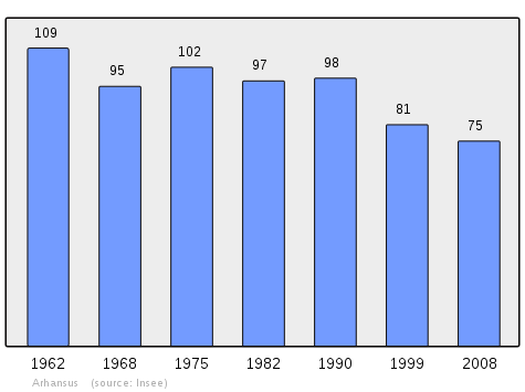
In 2009 the commune had 74 inhabitants. The evolution of the number of inhabitants is known from the population censuses conducted in the commune since 1793. From the 21st century, a census of communes with fewer than 10,000 inhabitants is held every five years, unlike larger towns that have a sample survey every year.[Note 1]
| 1793 | 1800 | 1806 | 1821 | 1831 | 1836 | 1841 | 1846 | 1851 |
|---|---|---|---|---|---|---|---|---|
| 193 | 159 | 190 | 171 | 187 | 213 | 192 | 181 | 177 |
| 1856 | 1861 | 1866 | 1872 | 1876 | 1881 | 1886 | 1891 | 1896 |
|---|---|---|---|---|---|---|---|---|
| 163 | 137 | 150 | 125 | 146 | 136 | 120 | 99 | 115 |
| 1901 | 1906 | 1911 | 1921 | 1926 | 1931 | 1936 | 1946 | 1954 |
|---|---|---|---|---|---|---|---|---|
| 122 | 117 | 125 | 121 | 115 | 114 | 124 | 131 | 116 |
| 1962 | 1968 | 1975 | 1982 | 1990 | 1999 | 2006 | 2009 | - |
|---|---|---|---|---|---|---|---|---|
| 109 | 95 | 102 | 97 | 98 | 81 | 72 | 74 | - |
Economy
Economic activity is mainly agricultural. the commune is part of the Appellation d'origine contrôlée (AOC) zone of Ossau-iraty.
Culture and Heritage

Civil Heritage
Several sites in Arhansus are registered as historical monuments:
- The Protohistoric Camp at Castellu Cahara

- A second Protohistoric Camp at Portasanse.
- Houses and Farms (18th-19th century)
Religious Heritage
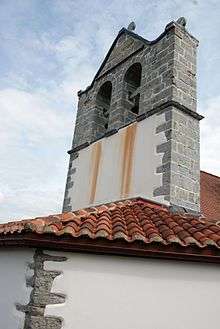
The Parish Church of Saint-Étienne (15th century)![]()
- The Church
.jpg) Stained Glass
Stained Glass.jpg) Relief
Relief
Hilarri in Arhansus
.jpg)
.jpg)
.jpg)
.jpg)
.jpg)
.jpg)
.jpg)
.jpg)
.jpg)
.jpg)
.jpg)
.jpg)
.jpg)
.jpg)
.jpg)
.jpg)
.jpg)
.jpg)
.jpg)
.jpg)
.jpg)
.jpg)
See also
External links
- ARHANTSUSI in the Bernardo Estornés Lasa - Auñamendi Encyclopedia (Euskomedia Fundazioa) (Basque, French, and Spanish)
- Arhansus on Lion1906
- Arhansus on Géoportail, National Geographic Institute (IGN) website (in French)
- Arhansus on the 1750 Cassini Map
Notes and references
Notes
- At the beginning of the 21st century, the methods of identification have been modified by Law No. 2002-276 of 27 February 2002 Archived 6 March 2016 at the Wayback Machine, the so-called "law of local democracy" and in particular Title V "census operations" allows, after a transitional period running from 2004 to 2008, the annual publication of the legal population of the different French administrative districts. For communes with a population greater than 10,000 inhabitants, a sample survey is conducted annually, the entire territory of these communes is taken into account at the end of the period of five years. The first "legal population" after 1999 under this new law came into force on 1 January 2009 and was based on the census of 2006.
References
- "Populations légales 2017". INSEE. Retrieved 6 January 2020.
- Brigitte Jobbé-Duval, Dictionary of place names - Pyrénées-Atlantiques, 2009, Archives and Culture, ISBN 978-2-35077-151-9 (in French)
- Euskaltzaindia - Academy of the Basque language
- Google Maps
- Géoportail, IGN (in French)
- Ministry of Culture, Mérimée PA00084316 Protohistoric Camp at Castellu Cahara (in French)

- Topographic Dictionary of the Department of Basses-Pyrenees, Paul Raymond, Imprimerie nationale, 1863, Digitised from Lyon Public Library 15 June 2011 (in French)
- Ministry of Culture, Mérimée PA00084414 Protohistoric Camp at Portasanse (in French)
- Pierre Lhande, Dictionary Basque-French, 1926 (in French)
- Jean-Baptiste Orpustan, New Basque Toponymy, Presses universitaires de Bordeaux, 2006, p. 93 ISBN 2 86781 396 4 (in French)
- Ministry of Culture, Mérimée IA64000791 Presentation of the commune of Arhansus (in French)
- Cassini Map 1750 – Arhansus
- Titles published by don José Yanguas y Miranda (in Spanish)
- List of Mayors of France (in French)
- Ministry of Culture, Mérimée IA64000820 Houses and Farms (in French)
- Ministry of Culture, Mérimée IA64000767 Parish Church of Saint-Étienne (in French)
| Wikimedia Commons has media related to Arhansus. |
| Authority control |
|
|---|