Villefranche-de-Lauragais
Villefranche-de-Lauragais is a commune in the Haute-Garonne department in southwestern France.
Villefranche-de-Lauragais | |
|---|---|
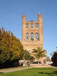 The church in Villefranche-de-Lauragais | |
.svg.png) Coat of arms | |
Location of Villefranche-de-Lauragais 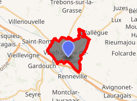
| |
 Villefranche-de-Lauragais  Villefranche-de-Lauragais | |
| Coordinates: 43°24′02″N 1°43′08″E | |
| Country | France |
| Region | Occitanie |
| Department | Haute-Garonne |
| Arrondissement | Toulouse |
| Canton | Revel |
| Government | |
| • Mayor (2008–2014) | Marie-Claude Bonnafous |
| Area 1 | 10.35 km2 (4.00 sq mi) |
| Population (2017-01-01)[1] | 4,519 |
| • Density | 440/km2 (1,100/sq mi) |
| Time zone | UTC+01:00 (CET) |
| • Summer (DST) | UTC+02:00 (CEST) |
| INSEE/Postal code | 31582 /31290 |
| Elevation | 168–256 m (551–840 ft) (avg. 175 m or 574 ft) |
| 1 French Land Register data, which excludes lakes, ponds, glaciers > 1 km2 (0.386 sq mi or 247 acres) and river estuaries. | |
Population
| Year | Pop. | ±% |
|---|---|---|
| 1962 | 2,522 | — |
| 1968 | 2,771 | +9.9% |
| 1975 | 2,948 | +6.4% |
| 1982 | 3,127 | +6.1% |
| 1990 | 3,316 | +6.0% |
| 1999 | 3,348 | +1.0% |
| 2008 | 4,012 | +19.8% |
gollark: All the computing is offloaded to Google via a little-known feature in Google Sheets.
gollark: Ah, but I do, since I want to work out what the original *encoded* frame was and avoid having to lossily compress it again.
gollark: Oh, I don't actually *use* it, when I want to download a video I just copy down the values of each pixel in each frame and use z3 to work out what the frames must be.
gollark: Well, my copy is on osmarks git™ so meh.
gollark: Huh, I just found an old architecture diagram for potatOS.
References
- "Populations légales 2017". INSEE. Retrieved 6 January 2020.
| Wikimedia Commons has media related to Villefranche-de-Lauragais. |
| Authority control |
|
|---|
This article is issued from Wikipedia. The text is licensed under Creative Commons - Attribution - Sharealike. Additional terms may apply for the media files.