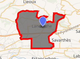
Landorthe
Landorthe is a commune in the Haute-Garonne department in southwestern France.
Landorthe | |
|---|---|
 The town hall in Landorthe | |
Location of Landorthe 
| |
 Landorthe  Landorthe | |
| Coordinates: 43°07′57″N 0°47′05″E | |
| Country | France |
| Region | Occitanie |
| Department | Haute-Garonne |
| Arrondissement | Saint-Gaudens |
| Canton | Saint-Gaudens |
| Intercommunality | Saint-Gaudinois |
| Government | |
| • Mayor (2008–2014) | Jeanine Brunet |
| Area 1 | 9.65 km2 (3.73 sq mi) |
| Population (2017-01-01)[1] | 991 |
| • Density | 100/km2 (270/sq mi) |
| Time zone | UTC+01:00 (CET) |
| • Summer (DST) | UTC+02:00 (CEST) |
| INSEE/Postal code | 31270 /31800 |
| Elevation | 343–463 m (1,125–1,519 ft) (avg. 380 m or 1,250 ft) |
| 1 French Land Register data, which excludes lakes, ponds, glaciers > 1 km2 (0.386 sq mi or 247 acres) and river estuaries. | |
Population
| Year | Pop. | ±% |
|---|---|---|
| 1962 | 172 | — |
| 1968 | 181 | +5.2% |
| 1975 | 389 | +114.9% |
| 1982 | 611 | +57.1% |
| 1990 | 757 | +23.9% |
| 1999 | 779 | +2.9% |
| 2008 | 937 | +20.3% |
gollark: That sort of thing is arguably an increasingly significant problem, since a lot of the modern technology we depend on is pretty dangerous or allows making dangerous things/contains dangerous components.
gollark: Or change them.
gollark: I'm not saying "definitely allow all weapons" (recreational nukes may be a problem), but that it would be nice to at least actually follow their own laws.
gollark: Do you think they would give you bear arms if you asked nicely?
gollark: I would... kind of agree with that, actually, since it just says "right to bear arms".
References
- "Populations légales 2017". INSEE. Retrieved 6 January 2020.
| Wikimedia Commons has media related to Landorthe. |
This article is issued from Wikipedia. The text is licensed under Creative Commons - Attribution - Sharealike. Additional terms may apply for the media files.