Vendoire
Vendoire is a commune in the Dordogne department in Nouvelle-Aquitaine in southwestern France.
Vendoire | |
|---|---|
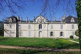 The chateau in Vendoire | |
Location of Vendoire 
| |
 Vendoire  Vendoire | |
| Coordinates: 45°24′58″N 0°18′13″E | |
| Country | France |
| Region | Nouvelle-Aquitaine |
| Department | Dordogne |
| Arrondissement | Périgueux |
| Canton | Ribérac |
| Intercommunality | Verteillacois |
| Government | |
| • Mayor (2008–2014) | Alain Lucas |
| Area 1 | 11.65 km2 (4.50 sq mi) |
| Population (2017-01-01)[1] | 134 |
| • Density | 12/km2 (30/sq mi) |
| Time zone | UTC+01:00 (CET) |
| • Summer (DST) | UTC+02:00 (CEST) |
| INSEE/Postal code | 24569 /24320 |
| Elevation | 70–163 m (230–535 ft) (avg. 130 m or 430 ft) |
| 1 French Land Register data, which excludes lakes, ponds, glaciers > 1 km2 (0.386 sq mi or 247 acres) and river estuaries. | |
Geography
The Lizonne forms the commune's northern and western borders.
Population
| Year | Pop. | ±% |
|---|---|---|
| 1962 | 236 | — |
| 1968 | 183 | −22.5% |
| 1975 | 193 | +5.5% |
| 1982 | 176 | −8.8% |
| 1990 | 185 | +5.1% |
| 1999 | 149 | −19.5% |
| 2008 | 149 | +0.0% |
gollark: Some are worse, yes.
gollark: HelloBoi experiences anime?
gollark: Hello³boi⁴.
gollark: ++remind 7h fix https://github.com/Baidicoot/Baidicoot.github.io/blob/master/assets/main.css <@330678593904443393> protocol 27-sigma
gollark: Are we to operate esolangs core wars?
See also
References
- "Populations légales 2017". INSEE. Retrieved 6 January 2020.
| Wikimedia Commons has media related to Vendoire. |
| Authority control |
|
|---|
This article is issued from Wikipedia. The text is licensed under Creative Commons - Attribution - Sharealike. Additional terms may apply for the media files.